

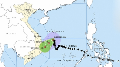
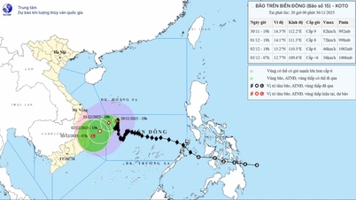
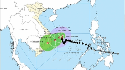
According to the National Center for Hydro-Meteorological Forecasting, at 7:00 a.m. on December 1, the center of the storm was located at about 14.7 degrees North latitude; 111.6 degrees East longitude, in the northwest sea area of the central East Sea. The strongest wind near the center of the storm was level 8 (62-74 km/h), gusting to level 10. Moving slowly to the West.
Forecast until 7am on December 2, the storm is in the northwest sea area in the middle of the East Sea, about 170km east of the east coast of Gia Lai - Dak Lak province, moving southwest at a speed of about 5km/h and gradually weakening. The strongest wind is level 6, gusting to level 8. The affected area is the northwest sea area in the middle of the East Sea, the sea area from Gia Lai to Khanh Hoa; disaster risk level 3.
By 7 p.m. on December 3, the storm was moving southwestward from Gia Lai to Khanh Hoa at a speed of about 10 km/h and weakened into a low pressure area. Wind force below level 6,
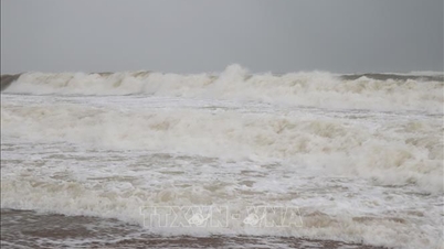
Due to the storm's influence, the northwest sea area in the central East Sea has strong winds of level 6; the area near the storm's eye has strong winds of level 7-8, gusting to level 10; waves 2-4m high, the area near the storm's eye 3-5m; rough seas.
Vessels operating in the above mentioned dangerous areas are susceptible to the impact of storms, whirlwinds, strong winds and large waves.
Source: https://baotintuc.vn/van-de-quan-tam/bao-so-15-gaybien-dong-manh-vung-giua-bien-dong-tau-thuyen-can-canh-giac-cao-20251201084205509.htm


![[Photo] Prime Minister Pham Minh Chinh receives President of Cuba's Latin American News Agency](/_next/image?url=https%3A%2F%2Fvphoto.vietnam.vn%2Fthumb%2F1200x675%2Fvietnam%2Fresource%2FIMAGE%2F2025%2F12%2F01%2F1764569497815_dsc-2890-jpg.webp&w=3840&q=75)


Comment (0)