
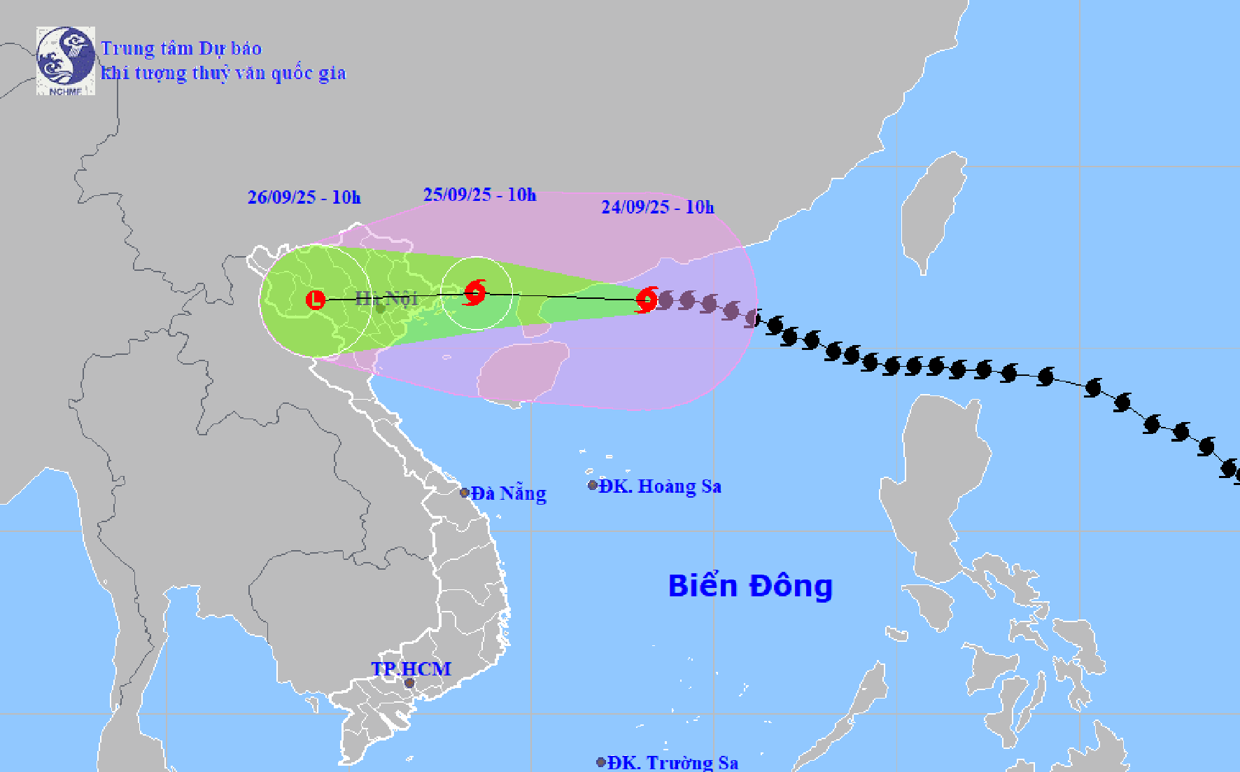
According to the National Center for Hydro-Meteorological Forecasting, at 10:00 a.m. on September 24, the center of storm Ragasa (storm No. 9) was at about 21.3 degrees north latitude; 113.2 degrees east longitude, about 570 km east of Mong Cai ( Quang Ninh ). The strongest wind was level 15 (167 - 183 km/h), gusting above level 17. The storm moved in the West Northwest direction at a speed of about 20 km/h.
It is forecasted that in the next 24 - 48 hours, Ragasa storm will move in the West Northwest direction. At 10:00 on September 25, the center of the storm will be at about 21.5 degrees north latitude; 108.5 degrees east longitude, on the coastal area of Quang Ninh - Hai Phong . The strongest wind near the center of the storm is level 10, gusting to level 12. The storm will continue to move in the West Northwest direction at a speed of 20 km/h and gradually weaken.
At 10:00 a.m. on September 26, storm Ragasa moved westward at a speed of about 20 km/h, weakening into a tropical depression, then a low-pressure area. The center of the low-pressure area was at about 21.3 degrees north latitude; 104.1 degrees east longitude, on the mainland of the Northwest region of the North.
Due to the influence of the storm, the Northwestern part of the East Sea has strong winds of level 10 - 12, near the center of the storm level 13 - 15, gusting over level 17. Waves over 10 m high, rough seas.
The Northeastern sea of Bac Bo Gulf (including Bach Long Vy) has strong winds of level 6 - 7, gusts of level 9. From the night of September 24, the North of Bac Bo Gulf (Bach Long Vy, Van Don, Co To, Cat Hai, Hon Dau) has winds gradually increasing to level 7 - 8, waves 2 - 4 m high; the area near the storm center has winds of level 9 - 11, gusts of level 13, waves 3 - 5 m high, and very rough seas.
Quang Ninh coastal area has storm surge of 0.4 - 0.6 m. Boats anchored near the shore and aquaculture areas are strongly affected by wind, big waves and rising sea levels.
From early morning of September 25, the coastal area from Quang Ninh to Hung Yen gradually increased to level 6 - 7, near the storm center level 8 - 9, gusting to level 11. Deep inland in the Northeast, the wind was level 5, in some places level 6, gusting to level 7 - 8.
From the night of September 24 to the end of the night of September 26, the North, Thanh Hoa and Nghe An will have heavy to very heavy rain, with rainfall ranging from 100 - 250 mm, and over 400 mm in some places. There is a high risk of flooding in low-lying areas, flash floods on small rivers and streams, and landslides in mountainous areas.
On the morning of September 24, after entering the sea area south of Guangdong province (China), super typhoon Ragasa (typhoon number 9) reduced its intensity to level 15 (no longer a super typhoon).
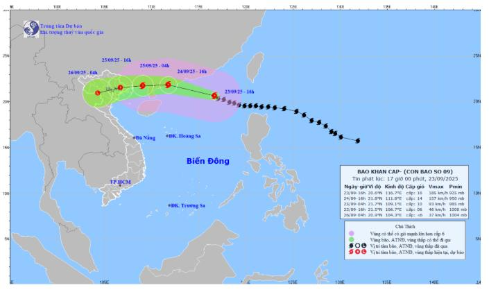
At 7:00 a.m. on September 24, the center of storm No. 9 was at about 21.3 degrees north latitude; 113.7 degrees east longitude, about 620km east of Mong Cai (Quang Ninh). The strongest wind near the center of the storm was level 15 (167 - 183 km/h), gusting to level 17. Moving in the West Northwest direction, speed about 20km/h.
It is forecasted that in the next 24 hours, storm No. 9 will move in the West Northwest direction, moving at a speed of 20 - 25 km/h and gradually weakening. At 7:00 a.m. on September 25, the center of storm No. 9 will be at about 21.5 degrees north latitude; 108.8 degrees east longitude; in the sea area of Quang Ninh - Hai Phong province. The strongest wind near the center of the storm is at level 10-11, gusting to level 13.
Due to the influence of storm No. 9, the northern sea area of the North East Sea has strong winds of level 10 - 12, near the storm center level 13 - 15, gusts above level 17, waves over 10m high, and rough seas.
From noon on September 24, the eastern sea area of the Northern Gulf of Tonkin (including Bach Long Vi special zone) will have winds gradually increasing to level 6 - 7, gusting to level 9. From the night of September 24, the northern Gulf of Tonkin (including Bach Long Vi special zone, Van Don, Co To, Cat Hai and Hon Dau island) will have winds gradually increasing to level 8, waves 2.0 - 4.0m high, the area near the storm center will have winds of level 9 - 11, gusting to level 13, waves 3.0 - 5.0m high; very rough seas.
The storm surge along the coast of Quang Ninh-Hai Phong is 0.4-0.6m high. Ships and boats anchored along the coast and aquaculture areas are strongly affected by strong winds, big waves and rising sea levels.
From early morning on September 25, the wind along the coast of Quang Ninh - Ninh Binh gradually increased to level 6 - 7, near the storm center level 8 - 9, gusting to level 11; deep inland in the Northeast, the wind was strong at level 5, in some places level 6, gusting to level 7 - 8.
From the night of September 24 to the end of the night of September 26, in the Northern region, Thanh Hoa and Nghe An, there will be heavy to very heavy rain with common rainfall of 100 - 250mm, locally over 400mm. Beware of heavy rain causing urban flooding. Heavy rain can cause flooding in low-lying areas; flash floods on small rivers and streams, landslides on steep slopes.
At 4:00 a.m. on September 24, the center of super typhoon Ragasa (storm No. 9) was at about 21.3 degrees north latitude; 114.3 degrees east longitude, in the northern sea of the North East Sea, about 650km east of Mong Cai (Quang Ninh). The strongest wind near the center of the super typhoon was level 15 - 16 (167 - 201 km/h), gusting above level 17. The storm moved in a West Northwest direction, at a speed of about 20km/h.
It is forecasted that in the next 24 hours, storm No. 9 will move in the West Northwest direction, at a speed of about 20 - 25 km/h and gradually weaken.
At 4:00 a.m. on September 25, the center of storm No. 9 was at about 21.6 degrees north latitude; 109.5 degrees east longitude, on the coastal area of Guangxi province (China); about 150km east of Mong Cai (Quang Ninh). The strongest wind near the center of the storm was level 11, gusting to level 13. The affected area was north of latitude 18.5 degrees north; west of longitude 118 degrees east.
At 4:00 a.m. on September 26, the center of storm No. 9 was at about 21.3 degrees north latitude; 103.8 degrees east longitude, on the mainland of the Northwest region. The storm moved westward at a speed of about 25 - 30 km/h, weakening into a tropical depression, then into a low pressure area.
Due to the influence of the storm, the northern sea area of the North East Sea has strong winds of level 10 - 13, the area near the center of the super storm has winds of level 14 - 16, gusts over level 17, waves over 10m high, and rough seas.
From noon on September 24, the sea area in the East of the North Gulf of Tonkin (including Bach Long Vi special zone) has gradually increased winds to level 6 - 7, gusts to level 9. From the night of September 24, the area in the North Gulf of Tonkin (including Bach Long Vi special zone, Van Don, Co To, Cat Hai and Hon Dau island) has gradually increased winds to level 8, waves 2.0 - 4.0m high, the area near the storm center has level 9 - 11, gusts to level 13, waves 3.0 - 5.0m high; very rough seas.
Coastal areas of Quang Ninh - Hai Phong have storm surges of 0.4 - 0.6 m. High risk of landslides, sea dykes, destruction of aquaculture areas, ships and boats anchored along the coast due to strong winds, rising sea levels and big waves.
From early morning on September 25, the wind along the coast of Quang Ninh - Ninh Binh gradually increased to level 6 - 7, near the storm center level 8 - 9, gusting to level 11; deep inland in the Northeast, the wind was strong at level 5, in some places level 6, gusting to level 7 - 8.
From the night of September 24 to the end of the night of September 26, in the Northern region, Thanh Hoa and Nghe An, there will be heavy to very heavy rain with common rainfall of 100 - 250mm, locally over 400mm. Beware of heavy rain causing urban flooding. Heavy rain can cause flooding in low-lying areas; flash floods on small rivers and streams, landslides on steep slopes.
Postpone unnecessary meetings, urgently respond to super typhoon Ragasa
In order to respond to super typhoon Ragasa early and from afar, ensure the safety of people's lives, minimize property damage, first of all for ships and activities at sea and along the coast; the Chairman of the City People's Committee requested the Chairmen of the People's Committees of communes, wards, special zones and heads of departments, branches, agencies and units to absolutely not be negligent, subjective, organize monitoring, update, and grasp the developments of the storm and the situation in the locality. Focus on leading, directing, reviewing, updating plans, being ready to immediately deploy measures to respond to super typhoon Ragasa with the most drastic spirit, early and from afar, proactively taking response measures at the highest level, anticipating the worst scenario to ensure the safety of people's lives, limit damage to people's and State's property, not to be passive and surprised in any situation.
Postpone unnecessary meetings, mobilize the entire political system, focus on leadership, direction, implementation, and supervision of response to super typhoon Ragasa.
Strengthen information, propaganda and mobilization work for people to take measures to prevent storms, heavy rains and floods, and protect people and property. Proactively direct and inspect storm prevention and control work at units, agency headquarters, public units in the sector, field and area of responsibility and organize immediate handling of incidents arising from the first hour according to the motto "4 on-site". Seriously organize on-duty and implement the reporting regime according to the regulations of the City Civil Defense Command. Proactively develop plans and organize the implementation of work to overcome the consequences of storms (if any) to minimize the impact on the organization of the 1st City Party Congress, term 2025 - 2030.
The People's Committees of communes, wards and special zones continue to review and proactively decide on plans to evacuate households in dangerous areas, especially coastal areas, areas at high risk of landslides, flash floods, deep flooding, old and weak housing areas to safe places; have plans to support temporary accommodation, food and necessities for people who have to evacuate, ensuring stable life and health for people at evacuation sites. Pay attention to thoroughly understand the attitude and service spirit of officials performing tasks at evacuation sites to be thoughtful, considerate and devoted to the people.
Organize inspections and implement measures to ensure the safety of dikes, dams, and irrigation works (especially at key locations) to promptly handle construction incidents from the first hour according to the "four on-site" motto; industrial zones, clusters, works under construction (especially high-rise buildings), wharves, ports, port logistics areas (note to lower the stacking height of containers and cranes), shipbuilding and repair facilities, traffic works, public works, tree trimming; power transmission systems, communications, mineral exploitation areas, aquaculture areas, farms, agricultural farms, production and business activities on river banks.
Be ready to deploy forces to guard and control people and vehicles in culverts, spillways, deeply flooded areas, areas with fast-flowing water, areas with landslides or areas where landslides have occurred; resolutely not allow people and vehicles to pass through if safety is not ensured, not allowing unfortunate human losses due to carelessness or subjectivity; deploy forces, materials and vehicles to overcome incidents, ensuring smooth traffic on main traffic routes when heavy rain occurs.
Proactively implement measures to drain water in the irrigation system to prevent flooding, protect crops and concentrated aquaculture areas; operate reservoirs according to approved operating procedures, provide early warnings to people in downstream areas before reservoirs discharge floodwaters and when there is a risk of incidents; review and have plans to ensure urban drainage in case of heavy rain causing flooding; implement measures to protect production to minimize damage.
Inspect dike and disaster prevention works, especially in coastal areas; promptly detect incidents and handle them according to the "4 on-site" principle. Proactively deploy backup plans in case of power outages to ensure command and control.
In addition to the above contents, communes, wards and coastal special zones must focus on urgently checking and counting all local boats, watercraft, cages, and aquaculture watchtowers operating at sea and along rivers; coordinate with relevant agencies by all means to inform ship owners and captains of boats and vehicles still operating at sea about the developments and forecast of the storm's movement (pay attention to thunderstorms and lightning situations before the storm hits); guide them to move out of and not enter areas at risk of being affected by the storm; call on and guide boats, vehicles, cages, and aquaculture watchtowers to safe shelters; guide and support the implementation of necessary measures to ensure the safety of boats at anchorages.
Implement storm prevention measures at sea, on islands, in coastal areas and on land as soon as possible, paying attention to proactively reinforcing the safety of houses, infrastructure works, sea dykes, limiting damage to production, especially agricultural production in coastal areas. Have plans to ensure safety for tourists on islands and coastal areas; create conditions and support for tourists who have to stay due to storms.
The People's Committees of Thuy Nguyen and Hong Bang wards urgently develop detailed storm prevention plans and plans to overcome storm consequences (if any) to ensure that the impact on the organization of the 1st City Party Congress, term 2025 - 2030, taking place in the area is minimized.
The City Military Command directed the City Border Guard Command to count and notify owners of vehicles operating at sea by all means to urgently move to safe shelters; strictly manage the activities of fishing boats, tourist boats, and transport ships; organize boat moorings; reinforce fishery cages; absolutely do not let people on boats, cages, fishery watchtowers when there are strong winds or storms, especially tourists at sea and on islands; keep in regular contact with owners of vehicles to promptly handle bad situations that may occur. Review and prepare forces to participate in rescue and support units and localities in preventing, combating, and overcoming consequences caused by storms...
Hai Phong Maritime Port Authority and the Northern Maritime and Waterways Sub-Department direct and guide ships and watercraft to anchor in waters managed by the unit to ensure safety and not affect other infrastructure works when an incident occurs.
Bac Hung Hai Irrigation Works Exploitation One Member Co., Ltd. proactively coordinates with localities to find solutions to drain and regulate water on the main canal system; deploy plans to protect the safety of the Bac Hung Hai irrigation main canal bank system...
At 1:00 a.m. on September 24, the center of super typhoon Ragasa (storm No. 9) was at about 21.2 degrees north latitude; 114.9 degrees east longitude, in the northeastern sea of the North East Sea, about 750km east of Mong Cai (Quang Ninh). The strongest wind near the center of the storm was level 15 - 16 (167 - 201 km/h), gusting above level 17. Storm No. 9 moved in the West Northwest direction, at a speed of about 20km/h.
It is forecasted that in the next 24 hours, storm No. 9 will continue to move in the West Northwest direction, at a speed of 20 - 25 km/h and gradually weaken. At 1:00 a.m. on September 25, storm No. 9 was at about 21.6 degrees north latitude; 110.2 degrees east longitude; in the area north of Leizhou peninsula (China); about 240 km east of Mong Cai (Quang Ninh). The strongest wind in the area near the storm's center is level 11 - 12, gusting to level 15. The affected area is north of latitude 18.5 degrees north; east of longitude 108.5 - 118.5 degrees east.
Due to the influence of the storm, the northern sea area of the North East Sea has strong winds of level 10 - 13, the area near the center of the super storm has levels 14 - 16, gusts over level 17, waves over 10m high, and rough seas. From September 24, the eastern sea area of the Northern Gulf of Tonkin (including Bach Long Vy special zone) has winds gradually increasing to level 6 - 7, gusts to level 9.
From the night of September 24, the northern area of Bac Bo Gulf (including Bach Long Vy, Van Don, Co To, Cat Hai and Hon Dau islands) will experience winds gradually increasing to level 8, waves 2-4m high, near the storm center will experience winds of level 9-10, gusts of level 12, waves 3-5m high; very rough seas.
Coastal areas of Quang Ninh - Hai Phong have storm surges of 0.4 - 0.6 m. High risk of landslides, sea dykes, destruction of aquaculture areas, ships and boats anchored along the coast due to strong winds, rising sea levels and big waves.
From early morning on September 25, the coastal area of Quang Ninh - Ninh Binh gradually increased to level 6 - 7, near the storm center level 8 - 9, gusting to level 11; deep inland in the Northeast, the wind was strong at level 5, in some places level 6, gusting to level 7 - 8.
From the night of September 24 to the end of the night of September 26, in the Northern region, Thanh Hoa and Nghe An, there will be heavy to very heavy rain with common rainfall of 100 - 250mm, locally over 400mm. Beware of heavy rain causing urban flooding. Heavy rain can cause flooding in low-lying areas; flash floods on small rivers and streams, landslides on steep slopes. During and before the storm makes landfall, beware of the risk of thunderstorms, tornadoes, and strong gusts of wind.
At 10:00 p.m. on September 23, the center of the storm was at about 21.0 degrees north latitude; 115.5 degrees east longitude, about 550km east of Leizhou Peninsula (China). Strongest wind: Level 15 - 16 (167 - 201km/h), gusting above level 17. Forecast in the next 3 hours, the storm will move in the West Northwest direction, speed about 20km/h.
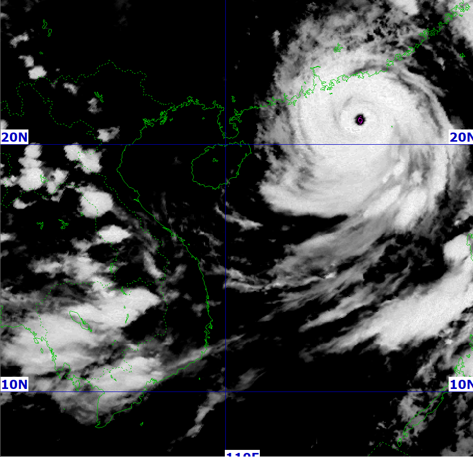
At 7:00 p.m. on September 23 , the center of the super typhoon was at about 20.8 degrees north latitude; 116.1 degrees east longitude, in the northeastern sea of the North East Sea. The strongest wind near the center of the super typhoon was level 15 - 16 (167-201 km/h), gusting to level 17. Moving in the West Northwest direction, at a speed of about 20 km/h.
Due to the influence of the super typhoon, the northern sea area of the North East Sea has strong winds of level 10-13, the area near the center of the super typhoon has winds of level 14-16, gusts above level 17, waves over 10m high, and very rough seas.
From September 24, the eastern sea area of the Northern Gulf of Tonkin (including Bach Long Vi special zone) will have winds gradually increasing to level 6 - 7, gusting to level 9. From the evening and night of September 24, the northern Gulf of Tonkin (including Bach Long Vi special zone, Van Don, Co To, Cat Hai and Hon Dau island) will have winds gradually increasing to level 8, waves 2.0 - 4.0m high, the area near the storm center will have winds of level 9 - 10, gusting to level 12, waves 3.0 - 5.0m high; very rough seas.
Coastal areas of Quang Ninh - Hai Phong have storm surges of 0.4 - 0.6m. High risk of landslides, sea dykes, destruction of aquaculture areas, ships and boats anchored along the coast due to strong winds, rising sea levels and big waves.
On land, from early morning on September 25, the wind along the coast of Quang Ninh-Ninh Binh gradually increased to level 6-7, near the storm center level 8-9, gusting to level 11; deep inland in the Northeast, the wind was strong at level 5, in some places level 6, gusting to level 7-8.
From the night of September 24 to the end of the night of September 26, in the Northern region, Thanh Hoa and Nghe An, there will be heavy to very heavy rain with common rainfall of 100 - 250mm, locally over 400mm. Beware of heavy rain causing urban flooding.
At 4:00 p.m. on September 23 , the center of the super typhoon was at about 20.6 degrees north latitude; 116.7 degrees east longitude, in the northeastern sea of the North East Sea. The strongest wind near the center of the super typhoon was level 16 (184-201 km/h), gusting to level 17. Moving in the West Northwest direction at a speed of about 20 km/h.
Forecast, by 4pm on September 24, the center of the super storm is at about 21.8 degrees north latitude, 111.8 degrees east longitude; on the mainland along the coast of Guangdong province (China); about 390km east of Mong Cai (Quang Ninh). The storm moves in the West Northwest direction, at a speed of 20-25km/h and gradually weakens. By 4am on September 26, the storm moves in the West Southwest direction, at a speed of 20-25km/h, weakening into a low pressure area.
.png)
At 1 p.m. on September 23, the center of the super typhoon was at about 20.3 degrees north latitude; 117.1 degrees east longitude, in the northeastern sea of the North East Sea. The strongest wind near the center of the super typhoon was level 16-17 (184-221 km/h), gusting above level 17. Moving in the West Northwest direction at a speed of about 20 km/h.
Forecast of strong winds, big waves, and rising water
According to the forecast of the Hai Phong City Hydrometeorological Station, due to the influence of super typhoon Ragasa (typhoon No. 9), the northern sea area of the North East Sea will have strong winds of level 10 - 14, the area near the center of the super typhoon will have winds of level 15 - 17, gusts above level 17, waves over 10 m high; rough seas.
From September 24, the eastern sea area of Bac Bo Gulf (including Bach Long Vy special zone) will have winds gradually increasing to level 6 - 7, gusting to level 9. From the evening and night of September 24, the Bac Bo Gulf area (including Bach Long Vy special zone, Cat Hai special zone, Lan Ha Bay, Hon Dau Island) will have winds gradually increasing to level 8 - 9, waves 2 - 4 m high, the area near the storm center will have winds of level 10 - 12, gusting to level 14, waves 4 - 6 m high; the sea will be very rough.
From early morning on September 25, coastal waters of Hai An, Dong Hai, Nam Trieu, Do Son, Nam Do Son, Duong Kinh wards, Chan Hung, Hung Thang, Kien Hai communes had winds gradually increasing to level 6 - 7, then increasing to level 8, near the storm center level 9 - 10, gusting to level 12.
On land, from early morning on September 25, communes and wards located deep inland of Hai Phong city have had strong winds of level 6 - 7, gusting to level 8 - 9.
Forecasting the impact of strong winds, all vessels, anchorages, aquaculture areas, sea dykes and other activities in the above sea areas are at very high risk of being affected by storms, whirlwinds, strong winds and big waves.
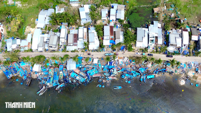
Strong winds break trees, damage houses, traffic works and infrastructure, endangering human lives.
The coastal areas of Hai Phong city have storm surges of 0.5-1.0m high. There is a high risk of landslides, sea dykes, and destruction of aquaculture areas and ships and boats anchored along the coast due to strong winds, rising sea levels, and large waves.
Moderate to heavy rain is forecast.
From the night of September 24 to September 26, the sea area of Bach Long Vi special zone will have heavy to very heavy rain with common rainfall from 150-200mm.
From the night of September 24 to September 26, the sea area of Cat Hai special economic zone - Lan Ha bay, the sea area of Hon Dau island, Nam Do Son ward, Do Son ward will have heavy rain with common rainfall from 100 - 150mm, locally over 150mm.
From the night of September 24 to September 26, inland areas will have moderate to heavy rain. Forecast locations: Thuy Nguyen, Le Chan, Hai An, Duong Kinh, An Duong, An Lao, Kien An, Tien Lang, Vinh Bao) with average rainfall of 80 - 130mm. Forecast locations: Hai Duong, Chi Linh, Thanh Ha, Kim Thanh, Ninh Giang, Thanh Mien, Cam Giang, Kinh Mon and Tu Ky with average rainfall of 70 - 120mm.
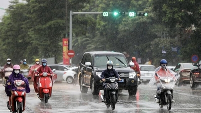
Due to the influence of the wide storm circulation, it is necessary to guard against the risk of thunderstorms, tornadoes and strong gusts of wind both before and during the storm. Thunderstorms and heavy rain can overload urban drainage systems, causing flooding in residential areas, traffic jams due to flooded roads and reduced visibility when driving, causing slippery roads and traffic accidents. Thunderstorms can be accompanied by tornadoes, lightning and strong gusts of wind that can break trees, damage houses, traffic works and infrastructure. Heavy rain in a short period of time can cause landslides in mountainous areas, flooding urban areas and low-lying areas.
Source: https://baohaiphong.vn/bao-ragasa-giat-cap-17-cach-quang-ninh-570km-bac-bo-mua-lon-tu-dem-24-9-521576.html


Comment (0)