
The storm is moving west-northwest at a speed of about 30 km/h and is forecast to quickly enter the North East Sea in the next 1-2 days.
During the day and night of November 9, the northeastern area of the East Sea will have northeast to north winds of level 6-7, later increasing to level 8-10, near the storm center level 11-13, gusting to level 16. Waves will be 4-6m high, later increasing to 6-8m, near the storm center can reach 8-10m, causing rough seas.
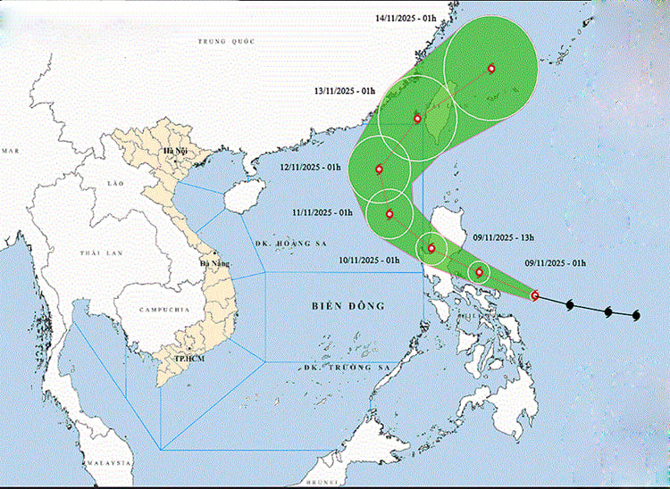
Location and path of storm Fung-wong. Photo: thoitietvietnam.gov.vn
At the same time, the sea area from Ca Mau to An Giang and the Gulf of Thailand will have scattered showers and thunderstorms; thunderstorms may cause tornadoes and strong gusts of wind. From the night of November 9, the northeastern area of the East Sea will begin to be affected by storms, big waves and strong winds.
Forecast at 1:00 a.m. on November 10, the storm center is at about 16.3 degrees North latitude; 120.5 degrees East longitude in the Lu Dong island area (Philippines), the strongest wind is level 14, gusts level 17, the storm moves in the West Northwest direction, speed 25-30 km/h. At 1:00 a.m. on November 11, the storm enters the eastern area of the northern East Sea, continues to weaken, with wind force level 13, gusts level 16. At 1:00 a.m. on November 12, the storm center is at about 20.6 degrees North latitude, 117.5 degrees East longitude, continues to weaken and moves in the North Northwest direction at speed 10-15 km/h.
At sea, the northeastern area of the East Sea maintains strong winds of level 6-7, then increasing to level 8-10; the area near the storm center has winds of level 11-13, gusts of level 16, waves of 4-6 m high, in some places 8-10 m, and very rough seas.
Warning: From November 10-12, the northeastern area of the East Sea is likely to be affected by strong storm winds of level 11-13, gusts of level 16, and waves of 8-10 m high, causing great danger to ships operating in the area.
Weather forecast for regions across the country:
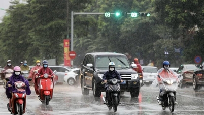
Hanoi capital is cloudy, scattered rain during the day; rain in some places at night. Northeast wind level 2-3. Cold early morning and night. Lowest temperature 21-23 degrees Celsius. Highest temperature 26-28 degrees Celsius.
The Northwestern provinces are cloudy with scattered showers and rain. Light wind. Cold mornings and nights, some places are freezing. Lowest temperature 19-22 degrees Celsius, some places below 19 degrees Celsius. Highest temperature 25-28 degrees Celsius, some places above 28 degrees Celsius.
The Northeastern region is cloudy with scattered showers during the day and rain in some places at night. Northeast wind level 2-3. Cold in the early morning and at night, some places in the mountains are cold. The lowest temperature is 20-23 degrees Celsius, some places in the mountains are below 20 degrees Celsius. The highest temperature is 26-29 degrees Celsius.
Provinces from Thanh Hoa to Hue: In the North, it is cloudy with scattered showers and rain; in the South, it is cloudy with scattered showers and thunderstorms. Wind from the north to northwest is level 2-3. During thunderstorms, there is a possibility of tornadoes, lightning and strong gusts of wind. In the North, it is cold in the early morning and at night. Lowest temperature 22-25 degrees Celsius. Highest temperature in the North is 27-29 degrees Celsius, in the South is 30-31 degrees Celsius, some places are over 31 degrees Celsius.
The South Central Coast region is cloudy with scattered showers and thunderstorms, sunny during the day. Light winds during the day, northeast winds at night at level 2-3. During thunderstorms, there is a possibility of tornadoes, lightning and strong gusts of wind. The lowest temperature is 23-26 degrees Celsius, in some places below 23 degrees Celsius. The highest temperature is 30-33 degrees Celsius.
The Central Highlands is cloudy with scattered showers and thunderstorms, sunny during the day; in the South, there will be scattered showers and thunderstorms in the late afternoon. Light wind. During thunderstorms, there is a possibility of tornadoes, lightning and strong gusts of wind. Lowest temperature 19-22 degrees Celsius. Highest temperature 27-30 degrees Celsius, some places above 30 degrees Celsius.
The South is cloudy, sunny during the day; scattered showers and thunderstorms in the evening, and showers and thunderstorms in some places at night. Southwest to west wind level 2-3. During thunderstorms, there is a possibility of tornadoes, lightning, and strong gusts of wind. Lowest temperature 23-26 degrees Celsius. Highest temperature 30-33 degrees Celsius.
Ho Chi Minh City is cloudy, sunny during the day, scattered showers and thunderstorms in the evening, and showers and thunderstorms in some places at night. Southwest wind level 2-3. During thunderstorms, there is a possibility of tornadoes, lightning, and strong gusts of wind. Lowest temperature 24-26 degrees Celsius. Highest temperature 31-33 degrees Celsius.
Source: https://baotintuc.vn/xa-hoi/thoi-tiet-ngay-911-bao-fungwong-manh-cap-15-giat-tren-cap-17-dang-tien-vao-bien-dong-20251109055041431.htm


![[Photo] Cutting hills to make way for people to travel on route 14E that suffered landslides](https://vphoto.vietnam.vn/thumb/1200x675/vietnam/resource/IMAGE/2025/11/08/1762599969318_ndo_br_thiet-ke-chua-co-ten-2025-11-08t154639923-png.webp)


![[Video] Hue Monuments reopen to welcome visitors](https://vphoto.vietnam.vn/thumb/402x226/vietnam/resource/IMAGE/2025/11/05/1762301089171_dung01-05-43-09still013-jpg.webp)


![Dong Nai OCOP transition: [Part 2] Opening new distribution channel](https://vphoto.vietnam.vn/thumb/402x226/vietnam/resource/IMAGE/2025/11/09/1762655780766_4613-anh-1_20240803100041-nongnghiep-154608.jpeg)


Comment (0)