
At 7:00 a.m. the same day, the center of the storm was determined to be at about 16.7 degrees North latitude and 113.7 degrees East longitude, with the strongest wind near the center of the storm reaching level 8 (ie from 62 to 74 km/h), gusting to level 10. The storm is currently moving in a West Northwest direction at a speed of about 10 km/h.
It is forecasted that in the next 24 to 72 hours, storm WUTIP will continue to move in a West-Northwest direction, then gradually shift to the Northwest direction, traveling about 10 to 15 km per hour. By the morning of June 12, the center of the storm is forecast to be at about 17.7 degrees North latitude and 114.2 degrees East longitude, continuing to directly affect the North East Sea area, including the waters of the Hoang Sa archipelago. The danger zone caused by the storm is determined from latitude 14.5 to 18.5 degrees North and longitude 110.0 to 115.5 degrees East. The level of natural disaster risk in this area is assessed at level 3.
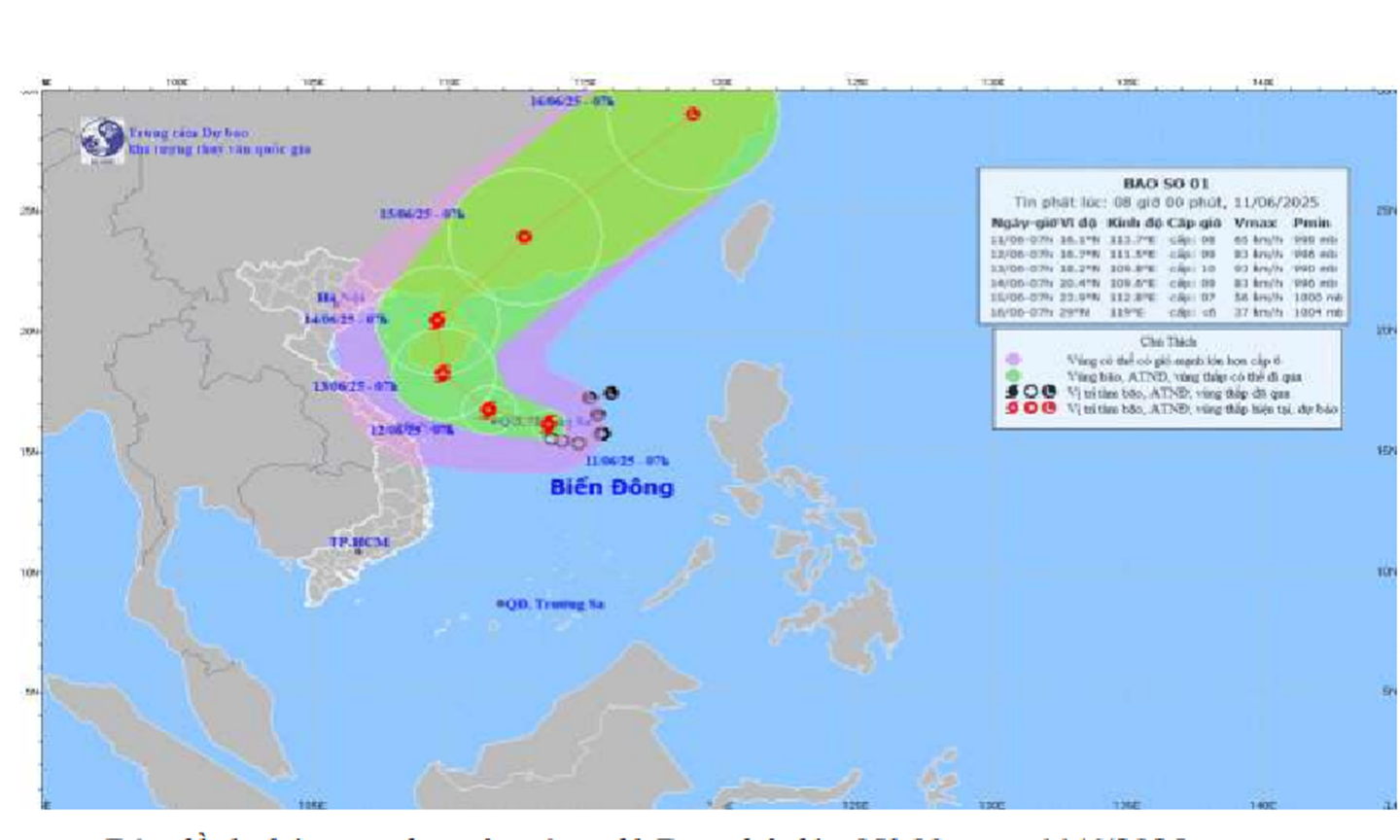 |
| Forecast map of the trajectory and intensity of storm No. 1. |
By the morning of June 13, the storm is forecast to approach the south of Hainan Island (China) and maintain a level 3 natural disaster risk. During the next 72 to 120 hours, the storm is likely to continue affecting the northern and north-central regions of Vietnam, causing strong winds, widespread heavy rains and dangerous weather at sea and on land.
Sea situation, the North East Sea area, including Hoang Sa archipelago, continues to have strong winds of level 8, gusting to level 10. Waves are 4 to 6 m high, very rough seas. The sea areas from Ba Ria - Vung Tau to Ca Mau (including Go Cong sea area in Tien Giang province) are also affected by strong southwest winds of level 5, sometimes level 6, gusting to level 7 to 8. Waves are 2 to 3 m high, rough seas.
In the mainland area of Tien Giang province, today and tonight, there will be scattered showers and thunderstorms, with some places experiencing moderate rain. The southwest wind is at level 2 to 3. People need to be alert to extreme weather phenomena such as tornadoes, lightning and strong gusts of wind during thunderstorms.
CAO THANG
Source: https://baoapbac.vn/xa-hoi/202506/bao-so-1-wutip-di-chuyen-vao-bien-dong-gay-thoi-tiet-xau-tren-dien-rong-1045022/


Comment (0)