
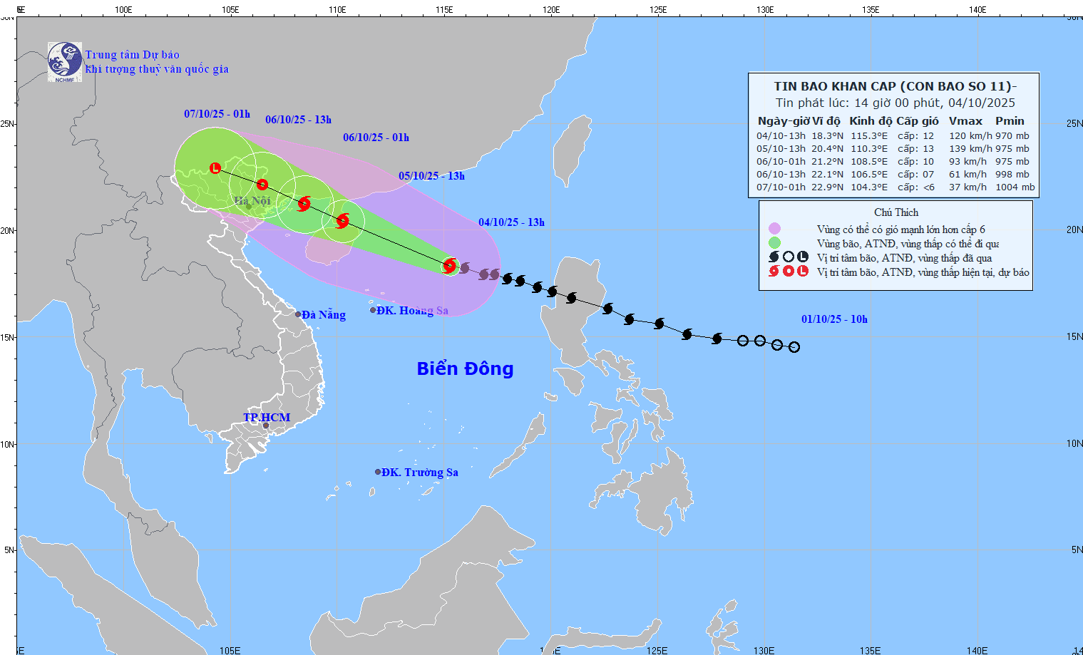
According to the forecast of the National Center for Hydro-Meteorological Forecasting, at 1:00 p.m. on October 4, the center of the storm was located at about 18.3 degrees North latitude; 115.3 degrees East longitude, in the North East Sea, about 500km East Southeast of Hainan Island (China).
The strongest wind near the storm center is level 11-12 (103-133km/h), gusting to level 15. The storm moves in a West Northwest direction at a speed of about 25km/h.
As of 1 p.m. on October 5, the storm is moving west-northwest at a speed of 20-25 km/h and is likely to intensify. The center of the storm is located at about 20.4 degrees North latitude; 110.3 degrees East longitude, in the sea east of Leizhou peninsula (China). The storm intensity is level 12-13, gusting to level 16. The dangerous area is north of latitude 16.5 degrees North and from longitude 109-118 degrees East. The disaster risk level is level 3, the affected area is the North East Sea.
At 1:00 a.m. on October 6, the storm continued to move in the West-Northwest direction, at a speed of about 20km/h, entering the northern area of the Gulf of Tonkin and gradually weakening. The center of the storm was located at about 21.2 degrees North latitude; 108.5 degrees East longitude, in the sea area of Quang Ninh - Hai Phong . The storm intensity was level 9-10, gusting to level 13. The dangerous area was located north of latitude 18.0 degrees North and east of longitude 113.0 degrees East. The natural disaster risk level was level 3, affecting the northwestern sea area of the North East Sea, the northern sea area of the Gulf of Tonkin and the coastal mainland area from Quang Ninh to Hung Yen.
At 1:00 p.m. on October 6, the storm moved in the West-Northwest direction at a speed of about 20km/h, entered the mainland and gradually weakened. The center of the storm was located at about 22.1 degrees North latitude; 106.5 degrees East longitude, on the Vietnam - China border area. The storm intensity was level 7, gusting to level 9. The dangerous area was located north of latitude 19.0 degrees North and east of longitude 112.0 degrees East. The natural disaster risk level was level 3, affecting the sea area of the North Gulf of Tonkin and the coastal mainland area from Quang Ninh to Hung Yen .
At 1am on October 7, the storm continued to move west-northwest at a speed of 15-20km/h, entering the western mountainous region of the North. At this time, the wind intensity decreased to below level 6.
The National Center for Hydro-Meteorological Forecasting warns that the weather at sea and in coastal areas during the storm is extremely dangerous, unsafe for any vehicle or structure in the danger zone, including cruise ships, passenger ships, transport ships, rafts, aquaculture areas, dykes and coastal routes. Vehicles are highly likely to capsize and be destroyed; at the same time, there is a high risk of flooding due to strong winds, big waves and rising sea levels.
From the night of October 5, coastal areas from Quang Ninh to Hung Yen will have strong winds of level 6-7, near the storm's eye, strong winds of level 8-9, gusts of level 10-11. Inland areas of the Northeast, strong winds of level 4-5, in some places level 6, gusts of level 7-8.
From the night of October 5 to the end of the night of October 7, mountainous and midland areas of the North will have heavy rain, with average rainfall of 150-250mm, and locally over 400mm. There is a risk of heavy rain with an intensity of over 150mm in 3 hours.
The Northern Delta and Thanh Hoa regions have moderate to heavy rain with common rainfall of 70-150mm, locally over 200mm.
The Hanoi area is unlikely to be directly affected by the storm. However, it is forecasted that from early morning on October 6 to the end of October 7, there will be moderate to heavy rain, with average rainfall of 70-120mm, and locally over 150mm.
According to the National Center for Hydro-Meteorological Forecasting, at 10:00 a.m. today, October 4, the center of storm Matmo (storm No. 11) was at about 18.2 degrees North latitude; 116.0 degrees East longitude, in the North East Sea, about 570 km East Southeast of Hainan Island (China).
The strongest wind near the storm center is level 11 (103 - 117 km/h), gusting to level 14. Moving in the West Northwest direction, speed about 25 km/h.
It is forecasted that in the next 12-60 hours, storm Matmo will move in the West-Northwest direction at a speed of 25km/h. At 10:00 on October 5, the center of the storm will be at about 20.3 degrees North latitude; 110.8 degrees East longitude, in the sea east of Leizhou peninsula (China).
Due to the influence of the storm, the North East Sea area has strong winds of level 8 - 10, the area near the storm's eye has winds of level 11 - 13, gusts of level 16, waves 4.0 - 6.0 m high, the area near the storm's eye has waves of 6.0 - 8.0 m, and the sea is very rough.
From the afternoon of October 5, the sea area east of the northern Gulf of Tonkin (including Bach Long Vi special zone) has winds gradually increasing to level 6 - 7, then increasing to level 8 - 9.
From the evening of October 5, the northern area of Bac Bo Gulf (including Bach Long Vi special zone, Cat Hai special zone - Lan Ha Bay and Hon Dau island) will have winds gradually increasing to level 8 - 9, waves 2.0 - 4.0m high, the area near the storm center will have winds of level 10 - 11, gusts of level 14, waves 3.0 - 5.0m high, and very rough seas.
From the night of October 5, coastal waters of Hai An, Dong Hai, Nam Trieu, Do Son, Nam Do Son, Duong Kinh wards and Chan Hung, Hung Thang, Kien Hai communes will see winds gradually increase to level 6-7, gusting to level 8-9.
From the night of October 5, the communes/wards in the Northeast and Southeast of Hai Phong city will have winds gradually increasing to level 5 - 6, gusting to level 7. The communes/wards in the Northwest and Southwest will have winds gradually increasing to level 4 - 5, gusting to level 6.
All vessels, anchorages, aquaculture areas, sea dykes and other activities in the above sea areas are at very high risk of being affected by storms, whirlwinds and strong winds.
On October 5, there will be showers and thunderstorms throughout the city. During thunderstorms, beware of tornadoes, lightning, and strong gusts of wind. From the night of October 5 to 6, there will be moderate to heavy rain, and very heavy rain in some places.
Be especially alert for thunderstorms, tornadoes, and lightning before storm Matmo makes a direct impact.
.jpeg)
To proactively prevent and minimize damage caused by storm Matmo, the Chairman of Hai Phong City People's Committee requested departments, branches and localities to absolutely not be subjective, closely monitor storm forecasts, and fully prepare necessary conditions to respond promptly. Be especially vigilant against thunderstorms, tornadoes and lightning that may occur before the storm directly affects.
Urgently review and deploy storm prevention plans approved in Plan No. 01/PA-UBND and Plan No. 213/KH-UBND dated August 25, 2025, ensuring they are appropriate to the level of natural disaster risk.
Strengthen propaganda so that people can grasp the storm situation, proactively prevent and ensure safety for people and property.
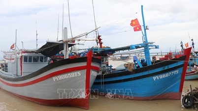
The City Border Guard is tasked with checking, counting and promptly notifying vessels operating at sea to plan safe anchoring and maintain communication to effectively respond to all situations.
The Department of Agriculture and Environment is responsible for inspecting and directing the work of ensuring the safety of the dyke system, irrigation, dams, especially in locations affected by the recent storm No. 10. The Director of the Department of Agriculture and Environment, Deputy Head of the City Civil Defense Command, directs the development and promulgation of scenarios for the City Civil Defense Command to specifically respond to the storm.
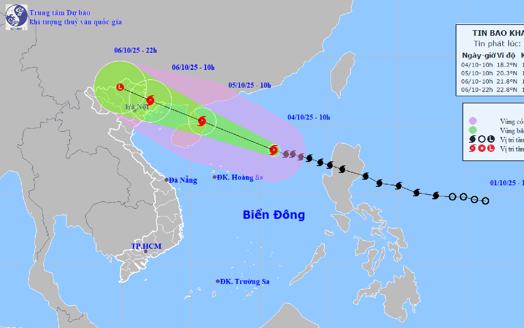
At 7:00 a.m. on October 4, the center of storm Matmo was at about 18.1 degrees North latitude; 116.9 degrees East longitude, in the eastern sea area of the northern East Sea, about 530km east-northeast of Hoang Sa special zone.
The strongest wind near the storm center is level 11 (103 - 117 km/h), gusting to level 14. The storm moves in the West Northwest direction at a speed of about 25 km/h.
It is forecasted that in the next 24 - 60 hours, storm Matmo will move in the West Northwest direction, at a speed of 20 - 25 km/h and is likely to strengthen. At 7:00 a.m. on October 5, the center of the storm was at about 19.9 degrees North latitude; 111.8 degrees East longitude, in the northwest area of the North East Sea, about 90 km east of Leizhou Peninsula (China). The strongest wind near the center of the storm is level 13, gusting to level 16.
Due to the influence of the storm, the northern East Sea area has strong winds of level 8 - 10, the area near the storm's eye has winds of level 11 - 13, gusts of level 16, waves 4.0 - 6.0m high, the area near the storm's eye has waves of 6.0 - 8.0m, and the sea is very rough.
From the afternoon of October 5, the sea area east of the northern Gulf of Tonkin (including Bach Long Vi special zone) has winds gradually increasing to level 6 - 7, then increasing to level 8 - 9.
From the evening of October 5, the northern area of Bac Bo Gulf (including Bach Long Vi, Van Don, Co To, Cat Hai and Hon Dau islands) will have winds gradually increasing to level 8 - 9, waves 2.0 - 4.0m high, near the storm center will have winds of level 10 - 11, gusts of level 14, waves 3.0 - 5.0m high, and very rough seas.
Coastal areas and islands in Quang Ninh - Hai Phong provinces will have storm surges of 0.4 - 0.6 m. Beware of flooding in low-lying coastal areas and river mouths due to surges and big waves from the afternoon and evening of October 5.
In the area from Quang Ninh to Ninh Binh, the wind will gradually increase to level 6 - 7, and in the area near the storm's eye, level 8 - 9. Inland areas in the Northeast, the wind will be strong at level 5, in some places level 6, gusting to level 7-8.
From the night of October 5 to the end of the night of October 7, in the Northern region, Thanh Hoa and Nghe An, there will be heavy to very heavy rain with common rainfall of 100 - 200mm, locally over 300mm; in the mountainous and midland areas of the North, the common rainfall will be from 150 - 250mm, locally over 400mm. Warning of the risk of heavy rain.
At 4:00 a.m. on October 4, the center of storm Matmo (storm No. 11) was at about 17.9 degrees North latitude; 117.4 degrees East longitude, in the eastern sea of the North East Sea, about 570km East Northeast of Hoang Sa special zone.
The strongest wind near the storm center is level 11 (103 - 117 km/h), gusting to level 14. The storm moves in the West Northwest direction at a speed of about 25 km/h.
It is forecasted that in the next 24 - 60 hours, storm Matmo will move in the West Northwest direction, at a speed of 20 - 25 km/h and is likely to strengthen.
At 4:00 a.m. on October 5, storm Matmo was located at approximately 19.7 degrees North latitude; 112.2 degrees East longitude; in the North East Sea, approximately 130km east of Leizhou Peninsula (China). The strongest wind near the storm center was level 13, gusting to level 16.
Due to the influence of the storm, the North East Sea area has strong winds of level 8 - 10, the area near the storm's eye has winds of level 11 - 13, gusts of level 16, waves 4.0 - 6.0m high, the area near the storm's eye has waves of 6.0 - 8.0m, the sea is very rough (extremely destructive, extremely strong waves. Sinking large ships).
From the afternoon of October 5, the sea area east of the Northern Gulf of Tonkin (including Bach Long Vi special zone) has winds gradually increasing to level 6 - 7, then increasing to level 8 - 9.
From the evening of October 5, the Northern Gulf of Tonkin area (including Bach Long Vi, Van Don, Co To, Cat Hai and Hon Dau islands) will have stronger winds of level 8 - 9, waves 2.0 - 4.0m high, near the storm center will be level 10 - 11, gusts of level 14, waves 3.0 - 5.0m high, and very rough seas (very rough seas, very dangerous for ships).
Coastal areas and islands in Quang Ninh - Hai Phong provinces have storm surges of 0.4 - 0.6 m. Beware of flooding in low-lying coastal areas and river mouths due to surges and big waves from the afternoon and evening of October 5.
From the night of October 5, on the mainland from Quang Ninh to Ninh Binh, winds will gradually increase to level 6 - 8, near the storm center level 9 - 10 (wind force can knock down trees, houses, electric poles, causing very heavy damage). Inland areas in the Northeast, winds will be strong at level 6, in some places level 7, gusting to level 8 - 9.
From the night of October 5 to the end of the night of October 7, in the Northern region, Thanh Hoa and Nghe An, there will be heavy to very heavy rain with common rainfall of 100 - 200mm, locally over 300mm; in the mountainous and midland areas of the North, common rainfall will be from 150 - 250mm, locally over 400mm.
Hai Phong heavy rain from night 10/5
According to the Hai Phong City Hydrometeorological Station, from the night of October 5 to the night of October 6, the entire city of Hai Phong will have moderate rain, heavy rain, and in some places very heavy rain and thunderstorms.
Rainfall is common in the areas: Bach Long Vi special zone, Cat Hai special zone - Lan Ha bay, Hon Dau island, Nam Do Son ward, Do Son ward, inland areas in the Northeast and Southeast (including forecast points: Thuy Nguyen, Le Chan, Hai An, Duong Kinh, An Duong, An Lao, Kien An, Tien Lang, Vinh Bao) with heavy rain, some places with very heavy rain and thunderstorms with common rainfall of 100 - 150mm, locally over 200mm.
The Northwest and Southwest mainland (including forecast locations: Hai Duong, Chi Linh, Thanh Ha, Kim Thanh, Ninh Giang, Thanh Mien, Cam Giang, Kinh Mon and Tu Ky) will have moderate rain, heavy rain and thunderstorms with common rainfall of 70 - 120mm, locally over 150mm. Due to the influence of the wide storm circulation, it is necessary to guard against the risk of thunderstorms, whirlwinds and strong gusts of wind both before and during the storm's landfall.
Source: https://baohaiphong.vn/bao-so-11-suy-yeu-dan-vao-trua-6-10-mua-lon-tiep-tuc-o-bac-bo-522528.html


Comment (0)