
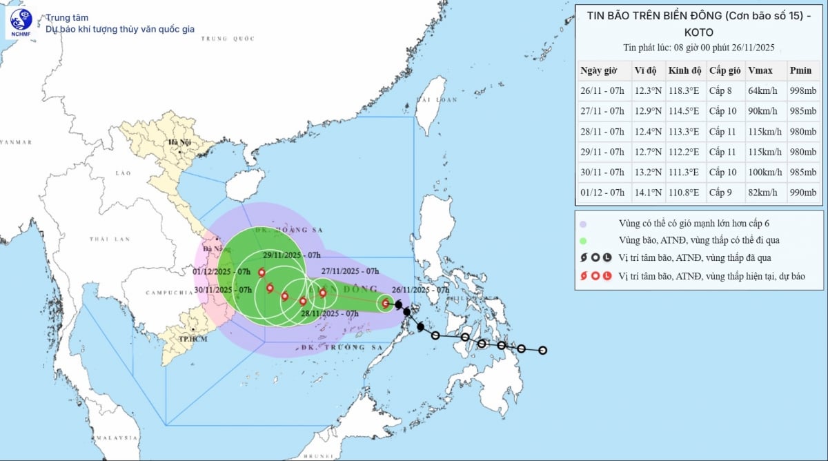
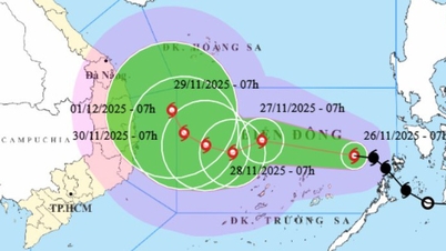
According to the National Center for Hydro-Meteorological Forecasting, at 7:00 a.m. on November 26, the storm was about 440 km east of Song Tu Tay Island, with the center of the storm at 12.2 degrees North latitude; 119.1 degrees East longitude. The strongest wind near the center of the storm reached level 8 (62-74 km/h), gusting to level 10.
The National Center for Hydro-Meteorological Forecasting said that at 7:00 a.m. on November 26, the center of the storm was at about 12.3 degrees North latitude; 118.3 degrees East longitude, about 440km east of Song Tu Tay Island. The strongest wind near the center of the storm was level 8 (62-74km/h), gusting to level 10. Moving northwest at a speed of about 25km/h.
 |
| Location and path of storm No. 15. Photo: thoitietvietnam.gov.vn |
Forecast of tropical depression/storm (in the next 24 to 48 hours): It is forecasted that by 7:00 a.m. on November 27, the storm will enter the central East Sea, about 200 km northeast of Song Tu Tay Island. At this time, the storm is likely to strengthen to level 10, gusting to level 13. The direction of movement will gradually shift to the West Northwest at a speed of 15-20 km/hour.
At 7:00 a.m. on November 28, the storm center was determined to be at 12.4 degrees North latitude; 113.5 degrees East longitude, about 150 km North-Northwest of Song Tu Tay. The storm intensity continued to increase, reaching level 11, gusting to level 14. The storm's direction tended to change to West-Southwest, speed reduced to 5-10 km/hour.
On the morning of November 29, the storm moved more slowly, its center was near 12.3 degrees North latitude; 112.4 degrees East longitude, about 250 km West Northwest of Song Tu Tay, still maintaining level 11 intensity, gusting to level 14. From the next 72 to 120 hours, the storm is likely to move in a Northwest direction at a speed of about 5 km/hour and gradually weaken.
Due to the influence of storm circulation and strengthening cold air, the North East Sea area (including Hoang Sa sea area) has strong northeast winds of level 7, gusting to level 9. Bach Long Vi station recorded strong winds of level 7, gusting to level 9; Con Co, Ly Son, Con Dao stations have gusts of level 7; Phu Quy alone has strong gusts of level 8-9.
In the central East Sea, especially the sea area north of Truong Sa, strong winds of level 6-7; near the storm center strong winds of level 8-10, gusts of level 13. Waves are 4-6 m high, especially in the storm center area can reach 6-8 m, very rough seas. During November 27-28, this area will be most strongly affected, winds can reach level 11, gusts of level 14; waves rise 7-9 m, rough seas.
According to vov.vn
Source: https://baovinhlong.com.vn/tin-moi/202511/bao-so-15-dang-di-chuyen-nhanh-cach-dao-song-tu-tay-khoang-440km-ve-phia-dong-4f714c4/


Comment (0)