
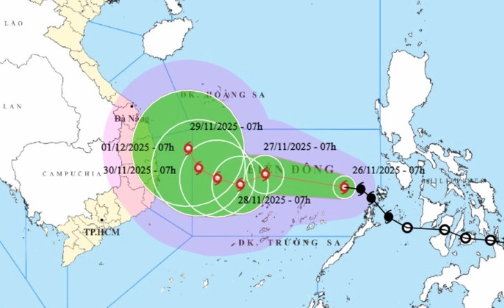
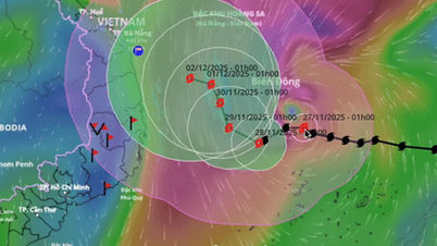
Forecast of location and direction of storm No. 15 at 7:00 a.m. on November 26 - Photo: NCHMF
On the morning of November 26, the National Civil Defense Steering Committee sent a telegram to ministries, departments, branches and provinces and cities from Quang Tri to Lam Dong about proactively responding to storm No. 15.
According to the National Center for Hydro-Meteorological Forecasting at 7am on November 26, the center of storm No. 15 was about 440km east of Song Tu Tay Island. The strongest wind near the center of the storm was level 8 (62-74km/h), gusting to level 10.
The storm is currently moving northwest at a speed of about 25km/h.
The latest forecast from the meteorological agency shows that today and tomorrow, the storm will move quite quickly in a west-northwest direction at a speed of about 20km/h and is likely to strengthen.
The maximum intensity of the storm in the East Sea is forecast to be level 11 (103-117km/h), gusting to level 14.
After passing through the northern area of the Spratly Islands, the storm is likely to change direction, move south and slow down.
At 7:00 a.m. on November 28, the storm center was about 160km northwest of Song Tu Tay Island and the storm's intensity was likely at level 11, gusting to level 14.
The storm is then likely to change direction, moving gradually northward, towards the sea areas of the central provinces and gradually weakening.
Yesterday, Mr. Nguyen Van Huong, Head of the Weather Forecast Department, National Center for Hydro-Meteorological Forecasting, said that after passing through the northern area of Hoang Sa archipelago, the path of storm No. 15 is relatively complicated due to three dominant forms: subtropical high pressure, westerly wind trough and cold air.
The storm's impacts on the mainland of our country will depend on the storm's path, however, whether the storm makes landfall in the Central region or not, this area will likely still have moderate to heavy rain from around November 28 to 30, focusing on areas from Hue to Lam Dong.
In the immediate future, due to the impact of storm No. 15, the central East Sea area (including the sea area north of Truong Sa special zone) will have strong winds of level 6-7; the area near the storm's eye will have strong winds of level 8-10, gusts of level 13, waves 4-6m high, the area near the storm's eye will have waves of 6-8m.
During November 27-28, the central East Sea area (including the sea area north of Truong Sa special zone) is likely to be affected by strong winds of level 11, gusts of level 14, waves 7-9m high, and rough seas.
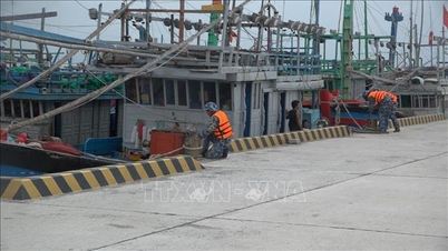
Vessels operating in the above mentioned dangerous areas are susceptible to the impact of storms, whirlwinds, strong winds and large waves.
Ready to respond to storm No. 15 and natural disasters
To proactively respond to the storm in the context that the Central region is continuing to overcome the consequences of the recent historic rain and flood, the National Steering Committee for Civil Defense requested the People's Committees of the South Central provinces to continue focusing on overcoming the consequences, restoring production and business, and stabilizing people's lives after the recent historic rain and flood according to the Prime Minister's Official Dispatch No. 227/CD-TTg.
Along with that, prepare response plans for storm No. 15 and subsequent natural disasters.
The National Steering Committee for Civil Defense also requested ministries, branches, sectors and localities to organize counting and notify owners of vehicles and captains of ships and boats operating at sea of the location, direction of movement and developments of the storm so that they can proactively avoid, escape or not move into dangerous areas.
At the same time, prepare forces and means to deploy rescue work when there is a situation.
Back to topic
WISDOM
Source: https://tuoitre.vn/bao-so-15-di-chuyen-phuc-tap-cac-tinh-nam-trung-bo-phai-san-sang-ung-pho-bao-va-thien-tai-moi-20251126083521561.htm

![[Photo] Close-up of heavy damage at the school located on the banks of the Ban Thach River](/_next/image?url=https%3A%2F%2Fvphoto.vietnam.vn%2Fthumb%2F1200x675%2Fvietnam%2Fresource%2FIMAGE%2F2025%2F11%2F26%2F1764152130492_ndo_bl_img-8188-8805-jpg.webp&w=3840&q=75)
![[Photo] VinUni students' emotions are sublimated with "Homeland in the Heart: The Concert Film"](/_next/image?url=https%3A%2F%2Fvphoto.vietnam.vn%2Fthumb%2F1200x675%2Fvietnam%2Fresource%2FIMAGE%2F2025%2F11%2F26%2F1764174931822_10-3878-jpg.webp&w=3840&q=75)


Comment (0)