
On the morning of November 26, Deputy Prime Minister Tran Hong Ha - Deputy Head of the National Steering Committee for Civil Defense chaired a meeting with ministries, branches and localities on responding to storm No. 15 (KOTO), which entered the East Sea at level 8 intensity, gusting to level 10.
The meeting connected online to connecting points in 6 provinces and cities: Da Nang , Quang Ngai, Gia Lai, Dak Lak, Khanh Hoa, Lam Dong.
According to the National Center for Hydro-Meteorological Forecasting, as of 7:00 a.m. on November 26, the center of the storm was located at about 12.3 degrees North latitude; 118.3 degrees East longitude, about 440km east of Song Tu Tay Island. The strongest wind near the center of the storm was level 8 (62-74km/h), gusting to level 10. Moving northwest at a speed of about 25km/h.
From the next 72 to 120 hours, the storm will move northwest at a speed of about 5km/h and gradually weaken. Forecast of the storm's impact: in the central East Sea area (including the sea area north of Truong Sa special zone), there will be strong winds of level 6-7; near the storm's eye, there will be strong winds of level 8-10, gusting to level 13; waves 4.0-6.0m high, near the storm's eye 6.0-8.0m; very rough seas.
Warning: During November 27-28, the Central East Sea area (including the sea area north of Truong Sa special zone) may be affected by strong winds of level 11, gusts of level 14, waves of 7.0-9.0m high, and rough seas. Vessels operating in the above-mentioned dangerous areas may be affected by storms, whirlwinds, strong winds, and large waves.
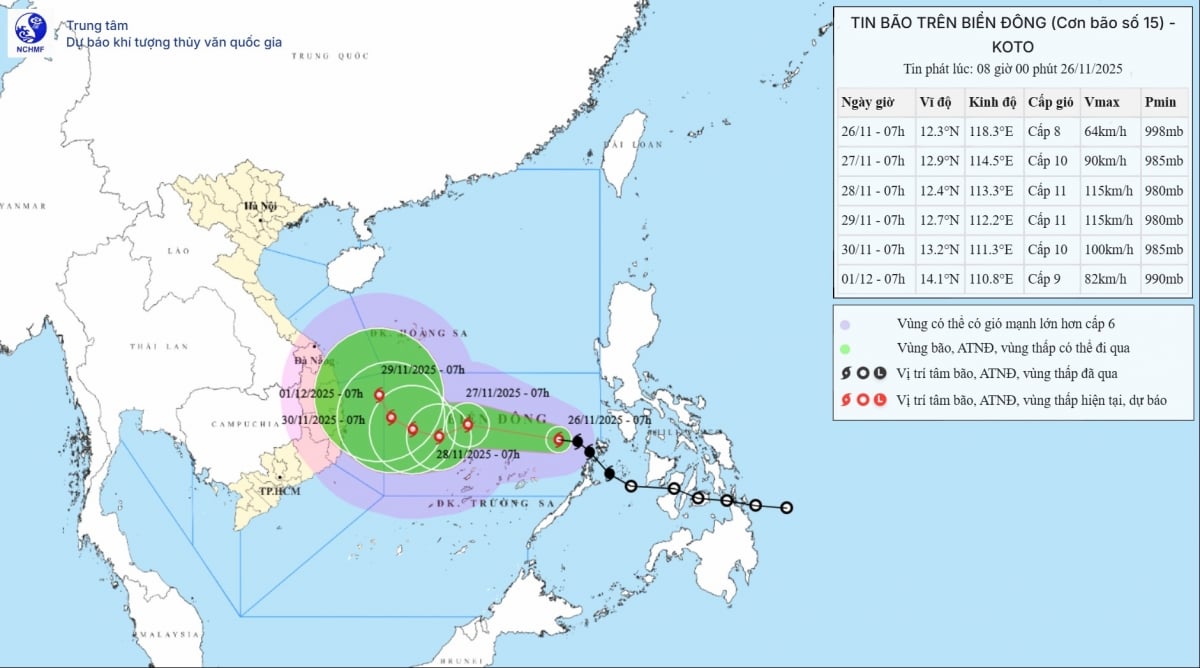 |
| Storm No. 15 (KOTO) has a level 8 intensity, level 10 gusts. |
3 scenarios for forecasting storm number 15
The Ministry of Agriculture and Environment said that the next developments of storm No. 15 will still have high dispersion among models and international hydrometeorological agencies. It is forecasted that from now until November 28, 2025, storm No. 15 will move in the West-Northwest direction, then move mainly in the West direction at a speed of about 20km/h; from November 28, when the storm moves close to the 113th meridian, the subtropical high pressure will weaken, a low pressure trough will appear in the West wind zone at an altitude of 5,000m, which is likely to change the direction of the storm and there are different possibilities regarding the path and impact of storm No. 15 on the sea areas as well as the mainland of Vietnam.
Accordingly, the first scenario forecast: The highest possibility is that the storm will change direction to the North when it reaches the Northwestern sea of Truong Sa special zone (about 500km east of the Gia Lai-Khanh Hoa coast (probability 70%): When the storm moves to the 113E meridian, the storm will change direction to the North, weaken into a low pressure area, then this low pressure area is likely to drift towards the mainland of the Central provinces.
The sea area to the east of the central East Sea will have winds gradually increasing to level 6-7; the area near the storm's eye will have strong winds of level 8-9, gusts of level 11, waves 4.0-6.0m high, and very rough seas. From November 27, the central East Sea area (including the sea area north of Truong Sa special economic zone) will likely be affected by strong winds of level 10-11, gusts of level 14, waves 7.0-9.0m high, and rough seas. There is little chance of storms on land.
The area from Da Nang to Lam Dong is likely to experience a large-scale heavy rain in the first days of December 2025, focusing on coastal areas. According to current analysis, the possibility of rain is not as extreme as the rain from November 16-21.
Forecast, bad scenario, the storm does not change direction, enters the Gia Lai - Khanh Hoa area (20% probability): The strongest storm intensity in the northern area of Truong Sa special zone can reach level 11, gusting to level 13. After that, it moves west towards the mainland of the Central provinces, focusing on the Gia Lai - Khanh Hoa area. The storm intensity will weaken to level 8 or tropical depression.
Coastal areas from Da Nang to Lam Dong provinces from November 29 will have strong winds of level 8, gusts of level 10, waves 3.0-5.0m high, and rough seas.
Coastal areas from Da Nang to Lam Dong may experience heavy rain of 150-250mm between November 29 and December 1, 2025. According to current analysis, the possibility of rain is not as extreme as the rain from November 16-21.
 |
| On the morning of November 26, Deputy Prime Minister Tran Hong Ha - Deputy Head of the National Steering Committee for Civil Defense chaired a meeting with ministries, branches and localities on responding to storm No. 15 (KOTO), which entered the East Sea at level 8 intensity, gusting to level 10. |
Scenario 3 forecast (10% probability): The storm dissipates at sea. It does not affect the mainland of our country, both rain and wind. Currently, the water level of the South Central rivers has dropped below alert level 1, except for some rivers in Dak Lak at higher levels such as the Ba River at alert level 1, the Srepok River at alert level 3 and the Krong Ana River at alert level 2.
According to the report of the Standing Office of the Civil Defense Command of the Border Guard Command, as of 6:00 a.m. on November 26, 49,327 vehicles/272,356 workers have been notified, counted, and instructed to know the developments and direction of storm No. 15 so that they can proactively move to avoid and escape from the dangerous area, including 92 ships/683 workers in the West of the Central East Sea. Currently, there are no vehicles in the dangerous area.
Deputy Minister of Agriculture and Environment Nguyen Hoang Hiep suggested that localities closely monitor the developments of storm No. 15, strictly manage vessels going out to sea; organize counting and notify owners of vessels and captains of ships and boats operating at sea of the location, direction of movement and developments of the storm to avoid, escape or not move into dangerous areas.
Directing the operation of lowering the water level of upstream reservoirs to prioritize flood reduction capacity for downstream areas. At the same time, reviewing response plans for storms making landfall and post-storm floods in the context of the South Central provinces urgently overcoming the consequences of recent floods.
 |
| Mr. Mai Van Khiem, Director of the National Center for Hydro-Meteorological Forecasting, updated the latest information on storm No. 15 at the meeting. |
According to Le Hoang/VOV.VN
Source: https://baovinhlong.com.vn/thoi-su/202511/bao-so-15-koto-du-bao-kich-ban-xau-nhat-la-di-vao-gia-lai-khanh-hoa-33d1ad7/
![[Photo] President Luong Cuong attends the 50th Anniversary of Laos National Day](/_next/image?url=https%3A%2F%2Fvphoto.vietnam.vn%2Fthumb%2F1200x675%2Fvietnam%2Fresource%2FIMAGE%2F2025%2F11%2F27%2F1764225638930_ndo_br_1-jpg.webp&w=3840&q=75)


![[Photo] Prime Minister Pham Minh Chinh chairs the 15th meeting of the Central Emulation and Reward Council](/_next/image?url=https%3A%2F%2Fvphoto.vietnam.vn%2Fthumb%2F1200x675%2Fvietnam%2Fresource%2FIMAGE%2F2025%2F11%2F27%2F1764245150205_dsc-1922-jpg.webp&w=3840&q=75)


Comment (0)