

It is forecasted that after making landfall in China, storm No. 7 will quickly weaken into a low pressure area, drift westward toward our country, causing widespread heavy rain in the North from the afternoon and night of September 9 to September 11, focusing on the midland and mountainous areas of the Northeast.
On the afternoon of September 6, Mr. Mai Van Khiem, Director of the National Center for Hydro-Meteorological Forecasting, said that this morning (September 6), a tropical depression was active in the eastern sea of the North East Sea. Compared to last night, the tropical depression strengthened one level with an intensity of level 7, gusting to level 9.
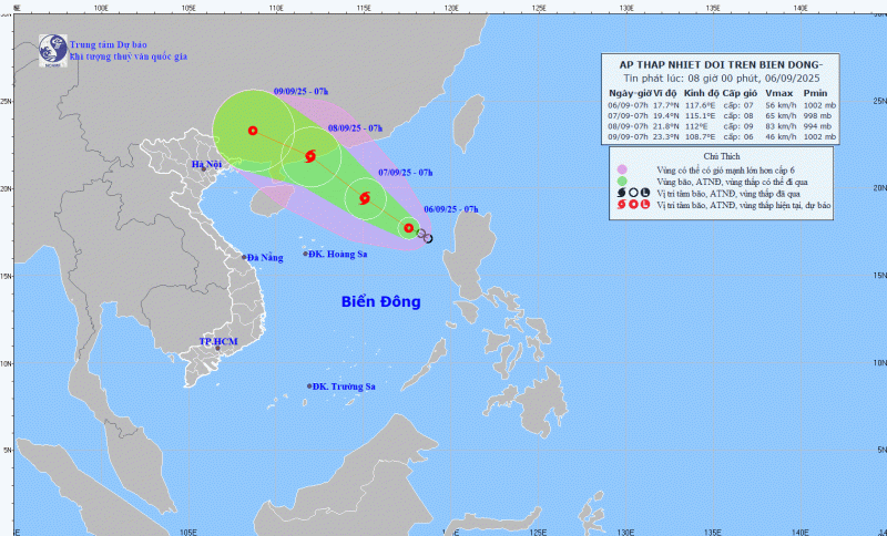
According to experts, the tropical depression is facing very favorable conditions to continue to strengthen, including warm sea surface, small wind shear and strong southwest monsoon.
Mr. Khiem informed that in just this evening or tonight (September 6), the tropical depression can strengthen into a storm with a probability of 70-80%. This is the 7th storm in the East Sea this year and the 16th storm in the Northwest Pacific region.
As of the afternoon of September 6, Vietnam's meteorological agency and international meteorological stations have similar assessments that, after strengthening into a storm this evening or tonight, storm No. 7 will continue to increase in intensity, reaching its strongest intensity when approaching the mainland coast of Guangdong province (China) around the morning and noon of September 8, that is, the morning and noon of Monday next week. The storm's strongest intensity could be level 10-11, gusting to level 13-14.
According to the National Center for Hydro-Meteorological Forecasting, this will be a very special and irregular storm. The storm's formation point is quite high, in the northern area of the North East Sea, and its direction of movement is much more to the north, entering China. Meanwhile, according to the usual rules, this time of year is the time when storms often affect the North or North Central regions of our country.
Although it has made landfall in China, storm No. 7 is forecast to still impact the northern mainland. It is forecasted that after making landfall in Guangdong province, the storm will quickly weaken into a low pressure area and drift westward toward our country.
The storm's circulation will cause widespread heavy rain in the North from the afternoon and night of September 9 to September 11, focusing on the midlands and mountainous areas of the Northeast. Thunderstorms are likely to include lightning, hail and strong gusts of wind.
Source: https://cand.com.vn/Xa-hoi/bao-so-7-se-gay-mua-lon-dien-rong-o-mien-bac-i780556/

![[Photo] Politburo works with the Standing Committees of Vinh Long and Thai Nguyen Provincial Party Committees](https://vphoto.vietnam.vn/thumb/1200x675/vietnam/resource/IMAGE/2025/9/8/4f046c454726499e830b662497ea1893)


![[Photo] Politburo works with the Standing Committees of Dong Thap and Quang Tri Provincial Party Committees](https://vphoto.vietnam.vn/thumb/1200x675/vietnam/resource/IMAGE/2025/9/8/3e1c690a190746faa2d4651ac6ddd01a)


![[Photo] Amazing total lunar eclipse in many places around the world](https://vphoto.vietnam.vn/thumb/1200x675/vietnam/resource/IMAGE/2025/9/8/7f695f794f1849639ff82b64909a6e3d)


Comment (0)