

News of storm number 7 Tapah in the East Sea
The National Center for Hydro-Meteorological Forecasting said that at 4:00 a.m. on September 7, the center of storm No. 7 Tapah was located in the northern sea area of the North East Sea. The strongest wind near the center of the storm was level 8-9 (62-88 km/h), gusting to level 11, moving in the West Northwest direction at a speed of 10 km/h.
Forecast in the next 24 hours, storm No. 7 Tapah in the sea south of Guangdong province (China), the strongest wind near the storm center is level 10, gusting to level 13, moving northwest, traveling 10-15km per hour, continuing to strengthen.

At around 4:00 a.m. on September 9, storm No. 7 Tapah on the mainland of Guangdong province (China), moved northwest at a speed of about 15km/h and gradually weakened with the strongest wind near the center at level 6-7, gusting to level 9.
According to the meteorological agency, although it makes landfall in China, after making landfall, storm number 7 will quickly weaken into a low pressure area, then drift westward, towards our country.
Impact of storm No. 7, the northern sea area of the North East Sea has strong winds of level 7-8, near the storm center, strong winds of level 9-10, gusts of level 13, waves 3-5m high, very rough seas.
Weather forecast for the next 10 days nationwide
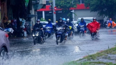
Last night and early this morning, September 7, from Da Nang to Lam Dong, there was rain, moderate rain and scattered thunderstorms, locally heavy to very heavy rain. The rainfall from 7pm on September 6 to 3am on September 7 was over 100mm in some places such as: Tam Ky station (Da Nang city) 121.4mm; Ia Pnôn station (Gia Lai) 132.4mm; Buon Trap station (Dak Lak) 128.8mm...
Forecast for the day and night of September 7, Da Nang City to Lam Dong and the South will continue to have rain, moderate rain and scattered thunderstorms, locally heavy to very heavy rain with common rainfall of 20-40mm, some places with heavy rain over 100mm. Warning of heavy rain, rainfall over 100mm in just 3 hours, posing many potential risks of natural disasters such as flash floods, landslides, and flooding.
On September 8, the above areas will have scattered showers and thunderstorms, with localized heavy rain in the afternoon and evening.
On September 7-8, the North and the area from Thanh Hoa to Ha Tinh will have showers and thunderstorms in some places, concentrated in the late afternoon and night, sunny during the day, with some places having hot weather.
Weather forecast for regions from the night of September 8 to September 16, the meteorological agency said that the North and Thanh Hoa will have widespread showers and thunderstorms in some places. In particular, from September 9 to 11, the post-storm circulation No. 7 is likely to cause widespread heavy rain in the North, focusing on the midlands and mountainous areas of the Northeast, with very heavy rain in some places.
During the forecast period, Nghe An to Ha Tinh will have scattered showers and thunderstorms. During the night of September 9-11, this area will have scattered showers and thunderstorms, with some places experiencing heavy to very heavy rain.
The Central Highlands and the South maintain the weather pattern of scattered showers and thunderstorms in the late afternoon and evening, locally heavy rain. Other areas have scattered showers and thunderstorms in the late afternoon and evening.
During thunderstorms, extreme weather events such as tornadoes, lightning, hail and strong winds can occur.
Source: https://baolaocai.vn/bao-so-7-tapah-con-manh-them-co-the-gay-mua-lon-dien-rong-o-mien-bac-post881485.html
![[Photo] Politburo works with the Standing Committees of Dong Thap and Quang Tri Provincial Party Committees](https://vphoto.vietnam.vn/thumb/1200x675/vietnam/resource/IMAGE/2025/9/8/3e1c690a190746faa2d4651ac6ddd01a)


![[Photo] Politburo works with the Standing Committees of Vinh Long and Thai Nguyen Provincial Party Committees](https://vphoto.vietnam.vn/thumb/1200x675/vietnam/resource/IMAGE/2025/9/8/4f046c454726499e830b662497ea1893)


![[Photo] Amazing total lunar eclipse in many places around the world](https://vphoto.vietnam.vn/thumb/1200x675/vietnam/resource/IMAGE/2025/9/8/7f695f794f1849639ff82b64909a6e3d)


Comment (0)