
On the morning of July 16th, after nearly a day of strengthening into a storm, Talim had wind speeds of 102 km/h, level 9-10, gusts up to level 13, and the possibility of further intensification.
According to the National Center for Meteorological and Hydrological Forecasting, at 7:00 AM, the storm's center was located 670 km east-southeast of the Leizhou Peninsula (China). Today, the storm is moving northwest at a speed of 10-15 km/h.
By 7 AM tomorrow, the storm's center will be located in the northern part of the South China Sea, approximately 340 km east-southeast of Leizhou, with maximum wind speeds of level 11, gusting to level 14.
In the following hours, the storm moved west-northwest at a speed of 15 km/h. By 7:00 AM on July 18th, the storm's center was over Leizhou, with maximum wind speeds of level 12, gusting to level 15.
The storm then maintained its direction and gradually weakened. By 7:00 AM on July 19th, the storm's center was located in the northeastern part of Northern Vietnam, with maximum wind speeds of level 6-7, gusting to level 9.
The Japan Meteorological Agency maintains its assessment from yesterday that the storm is currently at 126 km/h, but will weaken to 90 km/h as it passes through Leizhou and Hainan Island (China) before approaching the Vietnamese mainland.
The Hong Kong Observatory predicts the storm will remain at 140 km/h as it enters the Gulf of Tonkin, directly affecting the coastal provinces of Quang Ninh, Hai Phong , and the Northern Delta region.
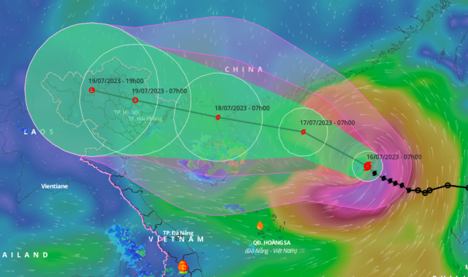
The projected path and affected area of Typhoon Talim, 7:00 AM on July 16th. Photo: NCHMF
Over the next 24 hours, the northern part of the South China Sea will experience strong winds of force 7, with winds near the storm's center reaching force 9-10, later increasing to force 11, with gusts up to force 14. The northern part of the South China Sea will have waves 5-7 meters high.
The National Steering Committee for Disaster Prevention and Control has requested provinces and cities from Quang Ninh to Thanh Hoa to manage vessels and boats going out to sea; depending on the actual developments of the storm in the locality, they should proactively prohibit sailing, including cargo ships and tourist boats.
The delta provinces are urged to proactively evacuate residents in low-lying areas at high risk of severe flooding due to heavy rain and rising sea levels; and at the same time, trim tree branches, reinforce houses, signs, public works, industrial zones, factories, warehouses, tall tower structures, and the power grid system.
In the northern mountainous region, it is necessary to evacuate people in areas at high risk of flash floods and landslides; prepare forces, vehicles, equipment, and essential supplies according to the "four on-the-spot" principle to be ready to respond to any situation.
Since the beginning of the year, no typhoons have appeared in the South China Sea. The meteorological agency predicts that from July 11th to August 10th, the tropical convergence zone will tend to be more active and stronger, leading to bad weather such as thunderstorms, tornadoes, and large waves; it forecasts 2-3 tropical depressions or typhoons operating in the South China Sea.
Source link


![[Photo] General Secretary and President To Lam presides over the meeting to approve the draft report on the results of the second inspection by the Politburo of the Standing Committee of the Hanoi City Party Committee.](https://vphoto.vietnam.vn/thumb/1200x675/vietnam/resource/IMAGE/2026/05/26/1779789811432_a2-bnd-4430-9620-jpg.webp)


Comment (0)