
On August 25, the Department of Culture, Sports and Tourism of Gia Lai province organized a scientific workshop to study the value and orientation for preserving and promoting the value of the Truong Luy relic in Gia Lai province and reported preliminary results of archaeological excavation of the Truong Luy relic.
The "Great Wall" of Central Vietnam
According to the Department of Culture, Sports and Tourism of Gia Lai , Truong Luy is a complex relic system including ramparts, ancient roads, moats and a system of forts/fortresses. The entire route stretches about 127.4 km from Quang Ngai to old Binh Dinh (now Gia Lai). Of which, the section passing through Gia Lai is about 14.4 km long.
Historical records show that the Great Wall was formed in the 16th century with a system of forts and fortresses to defend it. During the Nguyen Lords' time, especially under the Nguyen Dynasty in 1819 when Left General Le Van Duyet commanded the construction, the project was completed on a large scale.
The section passing through Gia Lai is about 14.4 km long.
PHOTO: TRUNG KIEN
The results of the excavation in June 2025 at sites such as Dong Ham post, H4 post, and An Quang post showed that the construction techniques were very creative and highly adaptable. The main materials were earth and stone, some sections were completely made of stone, some sections were a combination of earth filling inside and stone embankments outside. Some posts still had traces of entrances and guard towers.
Mr. Huynh Van Loi, Deputy Director of the Department of Culture, Sports and Tourism of Gia Lai, said that Truong Luy is a "great, valuable" project, likened to the "Great Wall of the Central region". This is not only a defensive project, but also a testament to the history of opening up new territories, cultural exchange and strategic thinking in border management of our ancestors.
Many issues need to be clarified.
According to Dr. Nguyen Cong Thanh, Director of the Master's Program in Vietnamese History (Quy Nhon University), Truong Luy Gia Lai has not been studied in depth. Many historical and cultural issues about this relic need to be further clarified, thereby identifying its value and creating a scientific basis for building a national relic profile.
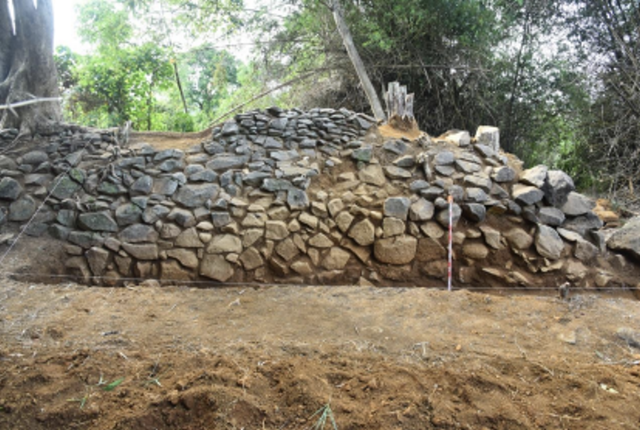
Gia Lai Citadel still retains many architectural forms and materials quite intact.
PHOTO: TRUNG KIEN
Regarding the date, Dr. Thanh said that there is an opinion that Gia Lai Citadel was built at the same time as Quang Ngai Citadel (1819). But based on historical documents of the Nguyen Dynasty, Gia Lai Citadel was actually built in 1876, much later, and at the same time, Binh Dinh Citadel and Quang Ngai Citadel were merged into "Ngai - Dinh" Citadel.
According to Dr. Thanh, in the early 19th century, to manage the western mountainous region of Bong Son, ensure security, and collect taxes, the Nguyen Dynasty established two sources, Tra Van and Tra Binh. The sources were special administrative units, with both economic and military functions. By the 1870s, the unstable situation made King Tu Duc approve the proposal of Governor General Binh - Phu Pham Y, to build the Truong Luy Binh Dinh (now in Gia Lai).
Another issue raised is the length of Gia Lai Long Luy. Some opinions say that the rampart starts from Da Lua hill, Hoai Nhon Bac ward, extending through An Hoa commune. However, the survey shows that the rampart was built from Bao Hop station, An Do village, Hoai Nhon Bac ward to quarter 2, An Lao commune.

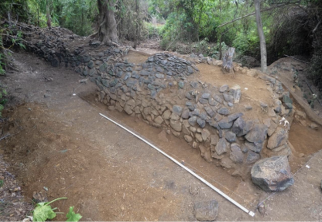
Dr. Nguyen Cong Thanh said that it is necessary to clarify many issues related to Truong Luu Gia Lai.
PHOTO: DUC NHAT
"Previously, researchers believed that Gia Lai Citadel was 14.4 km long. This data was also used by Binh Dinh Provincial Museum to establish a provincial relic profile. However, the measurement results based on Google Map in a straight line, the total length of the rampart is 16 km. In reality, the rampart was built along the mountainous area, many sections were built winding according to the terrain, some sections followed a semicircular curve, the estimated length of the rampart is about 19 km", said Dr. Thanh.
Similarly, Associate Professor Dr. Tran Quoc Tuan, Institute of Educational Sciences, said it is also necessary to clarify the time of construction, the participating forces and the purpose of using Truong Luy in terms of military and economic aspects, which comes first and which comes later. It is necessary to clarify some unclear points in the construction of Truong Luy Gia Lai, only then can the value of the relic be preserved and promoted.
seriously degraded
In June 2025, the Southern Institute of Social Sciences surveyed and excavated archaeological sites at the sites of Fort H4, Truong Luy, Fort Dong Ham, and Fort An Quang on an area of 200 m². The goal is to complete the research dossier, and propose to rank the rampart section passing through the province as a national monument.
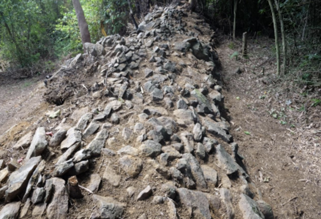
Many sections of the Great Wall are severely damaged by time, natural disasters and human activities.
PHOTO: TRUNG KIEN
The results obtained from the excavation have provided important documents, contributing to clarifying the construction techniques and structures of the ramparts and garrison at Truong Luy Gia Lai. The findings show that the construction techniques here are a flexible combination of the use of indigenous materials, defensive techniques and high adaptation to the natural terrain. The foundation structure and the defensive wall system reflect a significant level of military organization and construction techniques of the Nguyen Dynasty in the process of establishing a defense system for the border area between the plains and the mountains.
Dr. Nguyen Khanh Trung Kien, Deputy Director of the Southern Institute of Social Sciences, said that although the Gia Lai Long Luy is shorter than the Quang Ngai section, it still retains many architectural forms and materials quite intact. Historical records of the Nguyen Dynasty recorded that the entire Quang Ngai - Gia Lai route once had 115 forts/fortresses, including 4 large forts, notably Don Thu (Don Doi) in La Vuong village, Hoai Son commune (Hoai Nhon). The Gia Lai section alone has nearly 20 forts, with traces of stone foundations and defensive architecture still evident.
New historical sources and research show that this rampart was likely built later (in 1876) and then merged with the rampart in Quang Ngai, and is not completely consistent with the construction time of 1819. Therefore, further research is needed to clarify the construction date to include it in the national relic dossier.
According to Mr. Kien, Truong Luy Gia Lai was only included in the provincial relic inventory in April 2025. Therefore, this relic has not been properly protected. Many sections are severely damaged by time, natural disasters and human activities such as farming, road construction, and rock mining. Preservation is difficult because the relic is distributed on complex terrain, some sections are located in people's production land, making it difficult to delimit and clear. The cost of surveying, marking and protecting is also very large.

Dr. Nguyen Khanh Trung Kien, Deputy Director of the Southern Institute of Social Sciences, said that Truong Luy Gia Lai is seriously degraded.
PHOTO: DUC NHAT
The most urgent task at present is to quickly complete the scientific dossier to propose the ranking of Truong Luy Gia Lai as a national relic. This is the most important legal basis for implementing effective protection measures. Along with that, it is necessary to urgently implement immediate solutions such as zoning and marking the protection of Truong Luy. At the same time, build a comprehensive, long-term conservation plan, in which there is participation and harmonization of interests of the community living in the relic area.
The 113 km long Quang Ngai Citadel section, passing through the following areas: Tra Bong, Son Tinh, Son Ha, Tu Nghia, Minh Long, Nghia Hanh, Ba To, Duc Pho, was ranked as a national monument by the Ministry of Culture, Sports and Tourism on March 9, 2011.
Source: https://thanhnien.vn/can-lam-sang-to-nhieu-diem-mo-quanh-truong-luy-gia-lai-185250825144242283.htm


![[Photo] Dan Mountain Ginseng, a precious gift from nature to Kinh Bac land](/_next/image?url=https%3A%2F%2Fvphoto.vietnam.vn%2Fthumb%2F1200x675%2Fvietnam%2Fresource%2FIMAGE%2F2025%2F11%2F30%2F1764493588163_ndo_br_anh-longform-jpg.webp&w=3840&q=75)


Comment (0)