
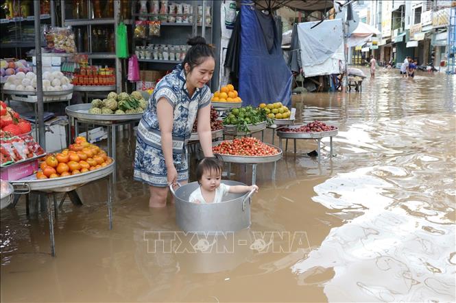
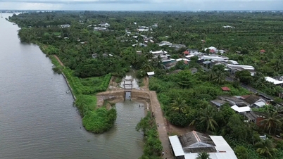
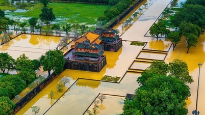
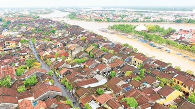
The highest water level at Vung Tau station is forecast to fluctuate between 4.5 and 4.15 meters. There is a risk of flooding in low-lying areas along the coast, along rivers, and areas outside the dyke in the East of the South in the late afternoon.
Hydrological experts note that high tides will slow down the flood drainage process on rivers in the Southeast. Low-lying coastal areas, river banks, and areas outside the dykes in the Southeast are likely to be flooded in the early morning and early afternoon. In addition, high tides during this period also increase saltwater intrusion in the fields.
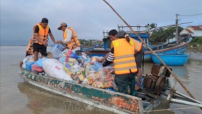
To proactively respond and minimize damage caused by high tides causing flooding in the coming time, the Department of Dyke Management and Natural Disaster Prevention and Control ( Ministry of Agriculture and Environment ) recommends that affected provinces and cities closely monitor forecasts and warnings, and promptly inform authorities and people at all levels to proactively prevent.
Authorities inspect and review coastal residential areas, dykes, dams, low-lying areas with high risk of flooding to proactively organize the relocation and evacuation of people when situations arise; clear the flow, and promptly handle construction incidents from the first hour.
Provinces and cities are ready to deploy measures to drain water and protect production; reinforce and protect aquaculture ponds; harvest crops and dry crops that are ready for harvest; prevent and combat flooding in urban areas and low-lying areas, ensuring minimal damage; notify owners of water transport vehicles about flooding to proactively take measures to ensure safety for people, vehicles, equipment and works.
Currently, the tide level in the eastern coast of the South is at a high level. The highest water level observed at Vung Tau station was 4m at 1:45 a.m. on October 8.
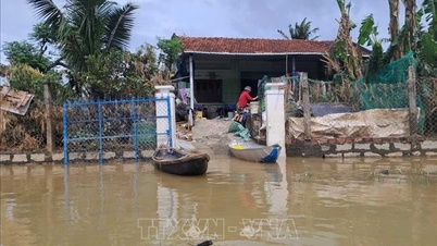
Along with that, due to the influence of upstream floods combined with high tides, the upstream water level of the Mekong River continued to rise and peaked from October 8-10, then changed.
slow. The flood peak on the Tien River at Tan Chau station is likely to rise to 3.9m, 0.1m below alert level 2; on the Hau River at Chau Doc station is likely to rise to 3.4m, 0.1m below alert level 2; at stations downstream of the Mekong River, it will rise to alert level 2-3, in some places 0.1-0.3m above alert level 3.
There is a high risk of flooding in low-lying areas, riverside areas, and areas outside the dykes in An Giang province and low-lying areas, riverside areas in Dong Thap, Can Tho, and Vinh Long provinces. Be careful of landslides and weak dykes in flooded areas.
Level 1 flood disaster risk.
River floods inundate low-lying areas along the river, affecting activities such as waterway transport, aquaculture, agricultural production, people's lives and socio- economic activities.
Source: https://baotintuc.vn/van-de-quan-tam/canh-bao-trieu-cuong-oven-bien-phia-dong-nam-bo-va-lu-tren-song-cuu-long-20251008113826191.htm
![[Photo] Prime Minister Pham Minh Chinh receives Governor of Gunma Prefecture (Japan) and Special Advisor to the Japan-Vietnam Friendship Parliamentary Alliance](/_next/image?url=https%3A%2F%2Fvphoto.vietnam.vn%2Fthumb%2F1200x675%2Fvietnam%2Fresource%2FIMAGE%2F2025%2F11%2F25%2F1764066321008_dsc-1312-jpg.webp&w=3840&q=75)

![[Photo] Close-up of Ba Ha River Hydropower Plant operating to regulate water to downstream](/_next/image?url=https%3A%2F%2Fvphoto.vietnam.vn%2Fthumb%2F1200x675%2Fvietnam%2Fresource%2FIMAGE%2F2025%2F11%2F25%2F1764059721084_image-6486-jpg.webp&w=3840&q=75)


![[Answer] Should I install an elevator for an old renovated house?](https://vphoto.vietnam.vn/thumb/402x226/vietnam/resource/IMAGE/2025/11/25/1764039191595_co-nen-lap-thang-may-cho-nha-cai-tao-cu-khong-04.jpeg)


Comment (0)