
According to the National Center for Hydro-Meteorological Forecasting, from November 28-30, the area from Da Nang to Lam Dong is likely to experience widespread heavy rain, in which the heaviest rain will be concentrated along the coastal strip.
The storm weakened as it approached land.
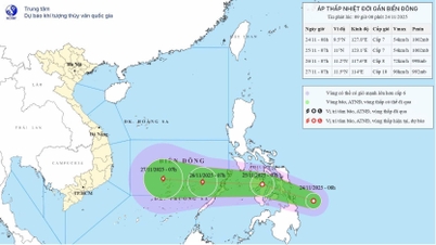
At 8:00 a.m. this morning, the center of the tropical depression was east of the Philippines and it is forecasted that in the next 1-2 days, the tropical depression will move west-northwest at a speed of about 20km/h.
Around the night of November 25 to the morning of November 26, the tropical depression will enter the East Sea. On November 26, when it is about 1,000km from the mainland of the South Central region, the tropical depression is likely to strengthen into a storm.

Forecast map of the tropical depression's trajectory and intensity issued at 9 a.m. on November 24. Photo: NCHMF .
According to Mr. Mai Van Khiem, Director of the National Center for Hydro-Meteorological Forecasting, the strongest intensity expected when passing through the northern area of Truong Sa special zone could reach level 10, gusting to level 13. After that, the storm will move westward, towards the mainland of the South Central region. The center of influence of the new storm is expected to be the area from Gia Lai to Lam Dong (the area from Binh Dinh to old Binh Thuan ), the main impact time is between November 28-30.
Initial assessment of the storm's impact on land, Mr. Khiem said: When entering coastal waters, the storm may decrease in intensity due to the impact of cold air and low sea surface temperatures in the South Central region. The storm's intensity when affecting land is forecast to be level 8-9 or decrease to become a tropical depression.
Although the storm winds are not strong, widespread heavy rain will occur from November 28-30 in the area from Da Nang to Lam Dong . The heaviest rain will be concentrated along the coastal strip. The hydrometeorological agency will continue to update the specific impacts of this storm in the coming days.
The Gulf of Tonkin has gradually stronger winds of level 7-8.
Although the storm has not yet arrived, the cold air has intensified in recent days, causing strong winds in the East Sea. It is forecasted that today and tonight (November 24), northeast winds and large waves will continue to be stronger. The northern East Sea area (including Hoang Sa special zone) will have winds of level 6, sometimes level 7, gusting to level 8-9; waves 3-5m high, rough seas.

The highest wave height in sea areas is forecast on November 24. Boats need to proactively respond to the risk of strong waves and strong winds. Photo: NCHMF .
The sea area from southern Quang Tri to Ca Mau, the sea area north of the central East Sea has wind level 5, sometimes level 6. By tonight, the wind will increase to level 6, gusting to level 7-8; waves 2-4m high and rough seas.
From the afternoon of November 24, the Bac Bo Gulf area will have stronger winds reaching level 6, gusting to level 7-8, rough seas and waves 2-4m high. Boats operating in the above areas are at risk of being affected by big waves and strong winds.
The flood of the rivers is receding, but the Kon River is rising.
On land, it is forecasted that during the day and night of November 24, in the area of Hue City, Da Nang City and the east of Quang Ngai Province, there will be moderate to heavy rain with common rainfall from 30-60mm, locally very heavy rain over 120mm. Localities, especially Gia Lai and Dak Lak, need to be extremely vigilant with the risk of landslides and flash floods in the coming time.
Regarding the flood situation, as of this morning (November 24), the flood on the Krong Ana River (Dak Lak) is receding; the Dong Nai River (Dong Nai), Srepok River (Dak Lak) are fluctuating; the Kon River (Gia Lai) is rising.
At 7:00 a.m. on November 24, the water level of the Krong Ana River was below alert level 3, the Dong Nai River was below alert level 2, the Kon River was 0.38 m below alert level 2, and the water level of the Srepok River at Ban Don station was still 3.58 m higher than alert level 3.
It is forecasted that in the next 6 hours, the flood on the Krong Ana River will continue to decrease and be below level 3; on the Kon River will continue to increase and be above level 2. In the next 12 hours, the flood on the Krong Ana River will continue to decrease and be above level 2; on the Kon River will fluctuate at level 2.
In the next 12-24 hours, the flood on the Krong Ana River will continue to decrease and stay above level 2; the flood on the Kon River will fall below level 2. The hydrometeorological agency warns that in the next 24 hours, the flood on the Dong Nai River will fluctuate above level 1; the flood on the Srepok River at Ban Don station will slowly decrease and remain at a high level above level 3.
With the above flood forecast, low-lying areas are still at risk of flooding in Dak Lak, including the following communes/wards: Son Hoa, Tay Hoa, Phu Hoa, Binh Kien, Duc Binh, Son Thanh, Phu Hoa 1, Tuy Hoa, Ea Phe, Ea Kly, Krong Pak, Cu Pui, Vu Bon, Krong Bong, Dang Kang, Hoa Son, Ea Ning, Dray Bhang, Ea Ktur, Dur Kmal, Dak Lieng, Lien Son Lak, Krong Ana, Nam Ka, Ea Na, Hoa Phu, Ea Nuol, EaWer, Buon Don, Ea Sup, Ea Rok, Ia Lop, Ea Bung, Ea R've.
In Gia Lai province, the communes/wards that are still flooded include: Tuy Phuoc, Tuy Phuoc Dong, Tuy Phuoc Tay, An Nhon, An Nhon Dong, Quy Nhon, Quy Nhon Dong, Quy Nhon Tay, Quy Nhon Nam, Quy Nhon Bac.
Along with flooding, there is a risk of landslides on the slopes of Gia Lai, Dak Lak and Dong Nai provinces.
Source: https://nongnghiepmoitruong.vn/con-bao-moi-kha-nang-gay-mua-lon-tu-da-nang--lam-dong-d786106.html


![[Photo] Next to the "mountain of trash" after the flood, Tuy Hoa residents strive to rebuild their lives](/_next/image?url=https%3A%2F%2Fvphoto.vietnam.vn%2Fthumb%2F1200x675%2Fvietnam%2Fresource%2FIMAGE%2F2025%2F11%2F24%2F1763951389752_image-1-jpg.webp&w=3840&q=75)


Comment (0)