
According to the announcement, Typhoon Wipha has officially entered the East Sea, becoming the third typhoon of 2025. Although the National Center for Meteorological and Hydrological Forecasting states that the typhoon will be directly affected from Quang Ninh to Thanh Hoa, in Phu Quy Special Economic Zone, where monsoon winds, low pressure systems, and tornadoes frequently occur after major storms, vigilance and proactive prevention measures are always prioritized.
According to Mr. Nguyen Van Linh, Vice Chairman of the People's Committee of Phu Quy Special Economic Zone, although the Ministry of Agriculture and Environment has not yet warned that Lam Dong province will be affected by typhoon No. 3, the local authorities are still not being complacent.
“We are in regular contact with the Department of Agriculture and Environment and relevant authorities such as the military and border guards to update the situation and develop response plans. All weather information is closely monitored, and information about the storm, its development, direction, and intensity is continuously broadcast on loudspeakers so that residents of the Special Economic Zone can stay informed. In particular, all vessels are strictly prohibited from leaving port if weather conditions are not safe,” Mr. Linh said.
According to Mr. Linh, the Special Administrative Region People's Committee has requested its subordinate units to review all disaster prevention and control plans, effectively implementing the "four on-the-spot" principle to proactively respond to any possible situation. "Our stance is to prevent damage caused by negligence," Mr. Linh emphasized.
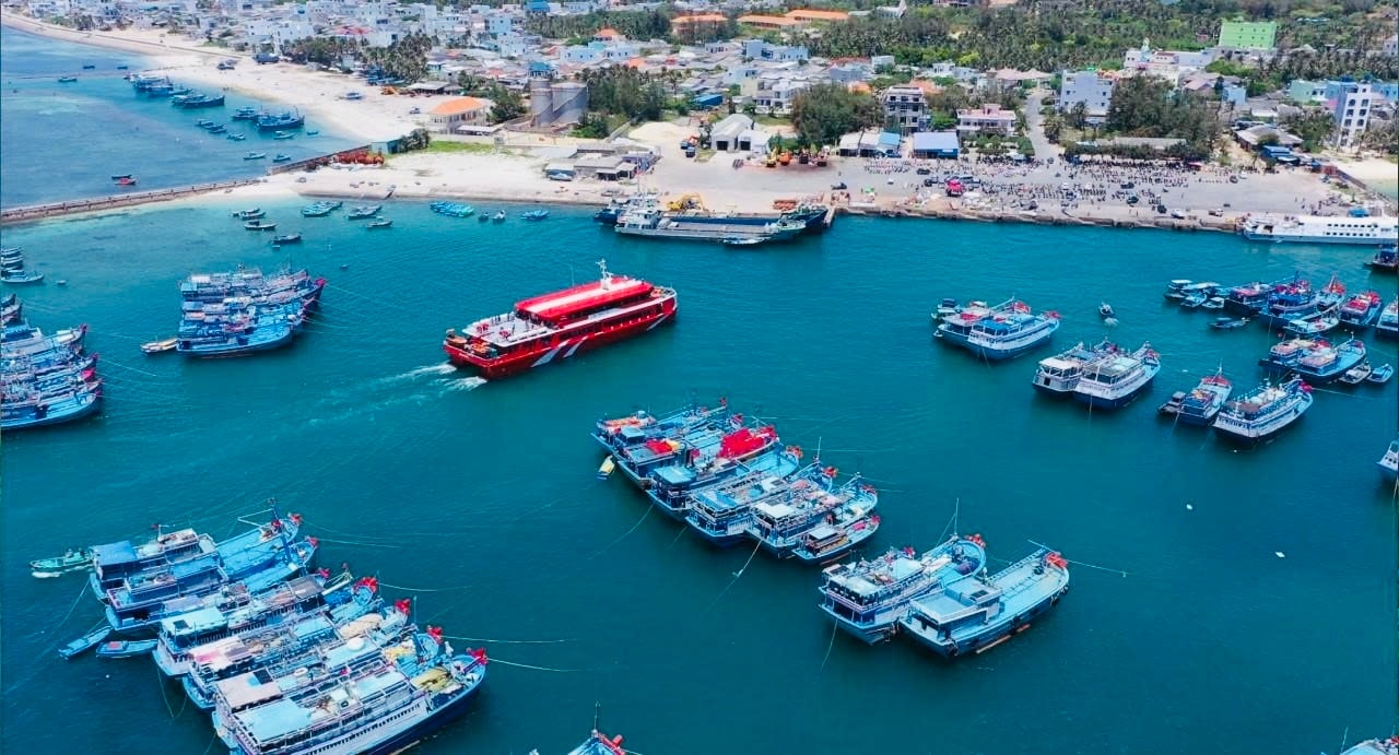
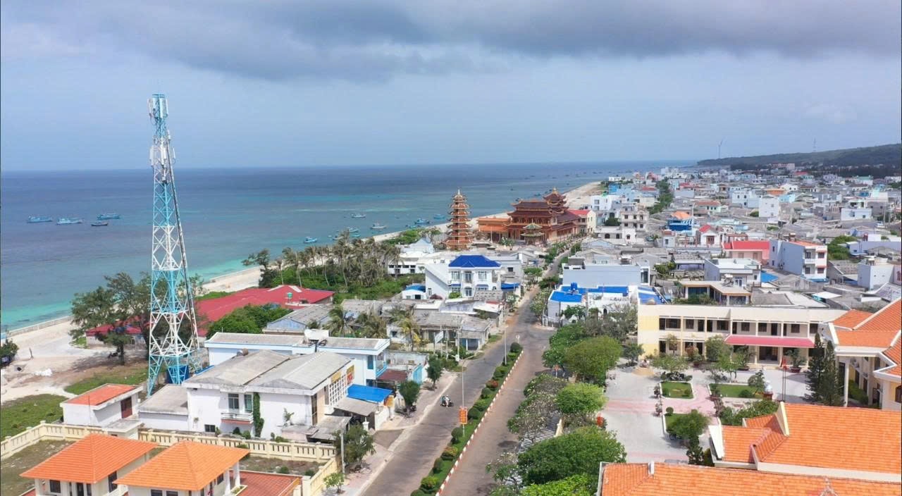
The Phu Quy Special Economic Zone currently has approximately 1,700 fishing vessels with 7,500 workers; of which, 594 vessels have a capacity of 90 horsepower or more. The seafood catch in 2024 is expected to exceed 36,000 tons. Proactively protecting people and fishing vessels remains a top priority.
Mr. Nguyen Van Cuong, a fisherman from the Phu Quy Special Economic Zone, said: “This year, the local authorities continuously updated the storm situation via loudspeakers. Thanks to this, fishermen were fully informed and did not become complacent. Upon hearing news of a storm, we immediately headed ashore, prioritizing protecting our boats and ensuring our safety. A strong storm is no joke; in the middle of the ocean, even a small whirlwind can be dangerous,” Mr. Cuong shared.
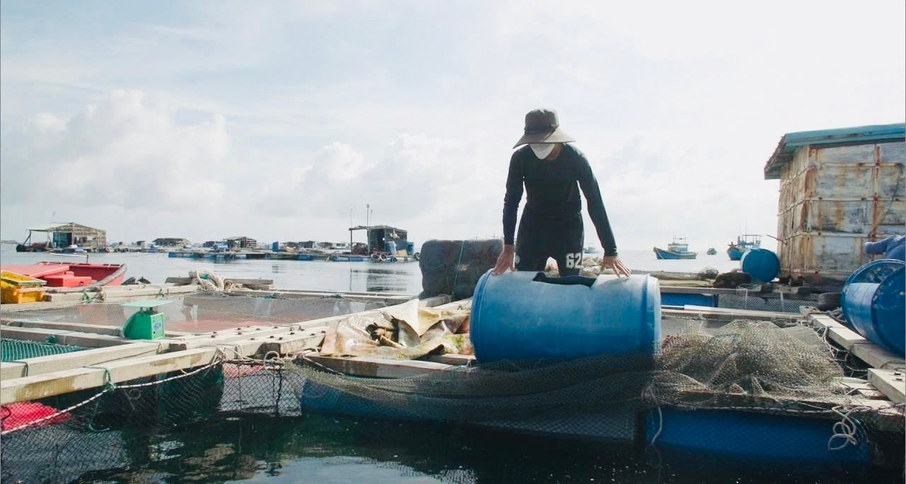
Besides fishing boats, the entire island currently has 72 aquaculture facilities, covering an area of nearly 14,500 m², mainly using cages and ponds. Protecting these facilities from the effects of large waves, rising tides, strong winds, etc., is also being prioritized.
The armed forces are one of the core units in disaster prevention and control. Mr. Cao Van Vuong, Commander of the Phu Quy Special Zone Military Command, said: “The unit has deployed forces to each coastal household, especially in aquaculture areas and fishing vessels preparing to go out to sea, to disseminate information and guide measures to prevent storm damage. Militia and regular troops have been deployed and are ready to provide support when situations arise. Besides the dissemination of information, specific plans for evacuating people, reinforcing houses, and protecting warehouses and essential infrastructure have also been implemented.”
Although not directly affected by Typhoon No. 3, Phu Quy Special Economic Zone has prepared comprehensive response plans and is on high alert. This is not only a timely measure to prevent and mitigate the effects of the typhoon, but also a way to protect peace and strengthen the confidence of nearly 30,000 people living, working, and making a living offshore in the country.
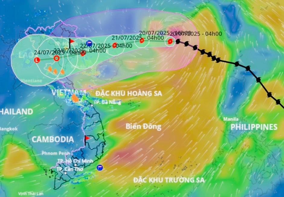
According to the National Center for Meteorological and Hydrological Forecasting's emergency storm warning, at 13:00 on July 20th, the storm's center was located at approximately 21.9°N; 113.4°E, in the northern part of the North East Sea, about 630 km east of Quang Ninh - Hai Phong.
The strongest winds near the center of the storm are at level 12 (118 – 133 km/h), with gusts up to level 15. The storm is moving westward at a speed of 20 – 25 km/h.
Due to the influence of the storm, the northern part of the North East Sea will experience strong winds of force 8-10, reaching force 11-12 near the storm's center, with gusts up to force 15; sea waves will be 5.0-7.0m high. The sea will be extremely rough.
From the night of July 20th, the northern part of the Gulf of Tonkin (including the special zones of Bach Long Vi, Co To, Cat Hai, and Hon Dau Island) will experience increasingly strong winds, reaching levels 6-7, then increasing to levels 8-9, with winds near the storm's center reaching levels 10-11, gusting to level 14. Sea waves will be 2.0-4.0 meters high, and 3.0-5.0 meters near the storm's center, resulting in extremely rough seas. The southern part of the Gulf of Tonkin (including Hon Ngu Island) will experience increasingly strong winds, reaching levels 8-9 near the storm's center, gusting to level 11. Sea waves will be 2.0-4.0 meters high, resulting in very rough seas.
Ships and boats operating in the aforementioned hazardous areas are susceptible to the effects of thunderstorms, tornadoes, strong winds, and high waves. Storm surge and flood warnings for coastal areas: The coastal areas of Hai Phong and Quang Ninh will experience storm surge of 0.5-1.0m, with a total water level of 4.0-5.0m. There is a high risk of flooding in low-lying coastal areas and river mouths around noon and afternoon of July 22nd.
On land, from the evening and night of July 21st, coastal areas from Quang Ninh to Nghe An will experience increasingly strong winds of level 7-9, near the storm's center level 10-11, gusting to level 14; in areas further inland, winds will be strong at level 6-7, gusting to level 8-9.
From July 21st to July 23rd, the Northeast region, the Northern Delta, Thanh Hoa and Nghe An will experience heavy to very heavy rain and thunderstorms with rainfall amounts generally ranging from 200 to 350 mm, and in some localized areas exceeding 600 mm; other areas in the Northern region and Ha Tinh will have moderate to heavy rain, with some localized areas experiencing very heavy rain and thunderstorms, with rainfall amounts generally ranging from 100 to 200 mm, and in some localized areas exceeding 300 mm.
Warning of high rainfall risk (>150 mm/3h)
Source: https://baolamdong.vn/dac-khu-phu-quy-san-sang-ung-pho-voi-bao-so-3-382956.html


![[Photo] The General Secretary, President and his wife lay flowers at the Ho Chi Minh Monument in Manila.](https://vphoto.vietnam.vn/thumb/1200x675/vietnam/resource/IMAGE/2026/05/31/1780219759477_anh-man-hinh-2026-05-31-luc-16-29-07.png)


![[Video] Sunset at Lap An Lagoon – Where the sun sets over the fishing nets](https://vphoto.vietnam.vn/thumb/340x192/vietnam/resource/IMAGE/2026/05/31/1780192137701_beach-landscape-sea-water-nature-grass-745871-pxhere-com.jpeg)


Comment (0)