
The National Center for Hydro-Meteorological Forecasting said that early this morning (November 26), the eye of the storm was about 540km east of Song Tu Tay Island. The strongest wind near the eye of the storm was level 8 (62-74km/h), gusting to level 10.
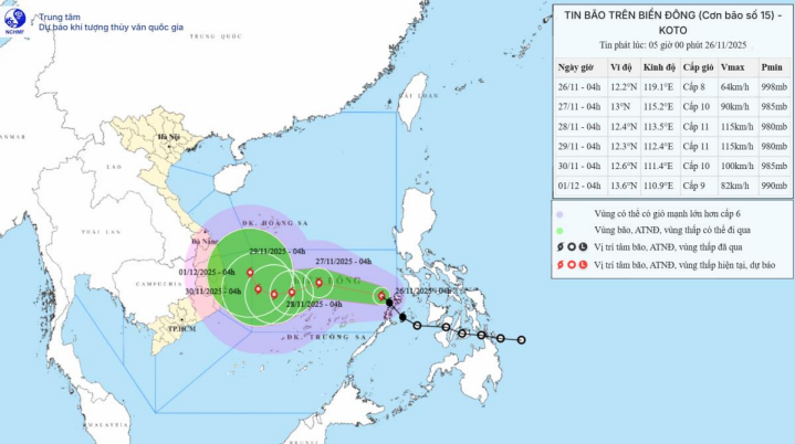
Forecast map of storm No. 15's trajectory and intensity released at 5:00 a.m. on November 26
It is forecasted that by tomorrow morning, the storm will move at a speed of 15-20km/h in the Central East Sea, about 200km northeast of Song Tu Tay Island and is likely to strengthen. Wind force is level 10, gusting to level 13.
By the morning of November 28, the storm was moving slowly at a speed of 5-10km/h in the Central East Sea, about 150km northwest of Song Tu Tay Island and was likely to strengthen. Wind force level 11, gust level 14.
By the morning of November 29, the storm was moving slowly at about 5km/h in the western sea area of the Central East Sea, about 250km west-northwest of Song Tu Tay Island. At this time, the wind was at level 11, gusting to level 14.
In the following hours, the storm moved to the Northwest at a speed of about 5km/h and gradually weakened.
The National Center for Hydro-Meteorological Forecasting warns that at sea, the Central East Sea area (including the sea area north of Truong Sa special zone) will have strong winds of level 6-7; near the storm's eye, strong winds of level 8-10, gusting to level 13; waves 4.0-6.0m high, near the storm's eye 6.0-8.0m; very rough seas.
During November 27-28, the Central East Sea area (including the sea area north of Truong Sa special zone) is likely to be affected by strong winds of level 11, gusts of level 14, waves 7.0-9.0m high, and rough seas.
Note, vessels operating in the above mentioned dangerous areas are susceptible to the impact of storms, whirlwinds, strong winds and large waves.
According to Government Newspaper
Source: https://baotuyenquang.com.vn/xa-hoi/202511/hinh-thanh-bao-so-15-koto-tren-bien-dong-3827f47/


Comment (0)