
Legend of Cao Dung
In the book Legend of Nam Blang (authored by Dak Nong Geopark Management Board), the legend of Ta Dung mountain, also known as B'Nam Tao Dung (now Dak Plao commune, Dak Glong district), was told by Mr. Tang Klao Ca as the village elder.
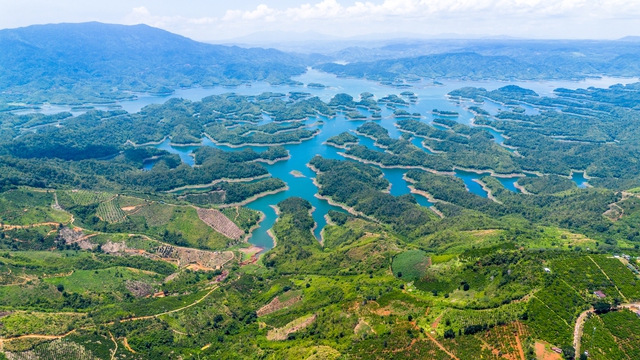
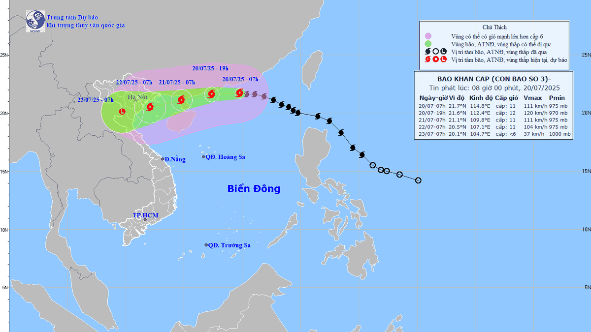
The beauty of Ta Dung Lake seen from above
PHOTO: HUU TU
In the past, this was a flat land with fertile soil and lush green trees. But every time there was a storm, the whole village of B'Nâm Pang Rah was submerged in water, making the villagers' lives miserable. Pitying the people of B'Nâm Pang Rah who had to endure the flooding, village elder Tang Klao Ca invited two brothers, the god Dit and the god Dri, who had extraordinary strength, to help the village.
Accepting the request of the village elder Tang Klao Ca, the two gods Dit and Dri went to see the god Vot Vong - the god who rules the sea, to ask for a few islands to protect the villagers from flooding when the water level rises. With the consent of the god Vot Vong, the gods Dit and Dri used rattan ropes to pull the mountains under the sea - the islands, to place around Bon B'Nâm Pang Rah. The mountain pulled first was called Cha mountain, followed by Me mountain and after that was Chu mountain, Anh mountain... Among them, Cha mountain was the tallest mountain.
After the gods pulled many mountains from the sea to protect the village, village elder Tang Klao Ca held a festival to thank heaven and earth to pray for favorable weather, good crops, healthy villagers, and prosperity and happiness for every family. The village elder invited the gods who controlled the mountains to attend with the villagers.
At the festival, people happily beat gongs, ate sticky rice, drank rice wine by the fire and chatted all night long... Near dawn, suddenly a snowstorm came and covered Bon B'Nâm Pang Rah in white. The strange thing was that after that snowstorm, everything in the festival turned into stone; gongs, drums, bronze pots, precious jars... also turned into stone and were blown away by the wind.
Not knowing why bad things happened to the village during the thanksgiving festival, village elder Tang Klao Ca hurriedly asked the gods what the village had done wrong to make the gods angry and cause disaster to the village; but the gods asked all shook their heads because they did not know the reason and promised to bring good things to the village.
Later, the villagers received a dream from the god Sieng Rut - the god who governs Cha mountain - that: "Because the village elder Tang Klao Ca and the villagers did not invite the god who governs Ba Tra when organizing the thanksgiving festival, there was a snowstorm."
According to legend, at the foot of Cha Mountain there is a very sacred forest called Ba Tra, where a very difficult and powerful god named Brieng resides - an evil bird, similar to an eagle.
To escape the snow, the B'Nâm Pang Rah tribe held an apology ceremony and invited the god Briêng and other gods to attend. After the apology ceremony, the Cha mountain area grew a lot of big sugarcane trees, several people could not hug them. From then on, the villagers named Cha mountain B'Nâm Tào Dung - in the Ma language, it means mountain with big sugarcane trees. Later, when another ethnic group came to live together, they "misnamed" it Ta Dung.
Later, whenever the village held a ceremony, such as: the ceremony to worship the Forest God, the ceremony to worship the water wharf, the ceremony to pray for rain, the ceremony to celebrate the new rice... the village elder and the shaman had to invite all the gods in the area to attend to pray for all the best for the village. And whenever the villagers went to Ba Tra forest, no one dared to joke around, afraid that it would bring disaster to their families and the village...
National tourist area planning
Located in Ta Dung National Park, about 45 km southeast of Gia Nghia City on Highway 28, Da Lat City ( Lam Dong ) about 120 km, Ta Dung is known as "Ha Long Bay on the plateau", with an area of about 22,000 hectares with about 40 large and small islands and peninsulas in the middle of a clear, quiet lake.
Coming to Ta Dung, visitors can travel by boat to enjoy the majestic scenery, weaving through the islands appearing in the middle of the calm lake. Ta Dung is surrounded by mountains and hills, located at an altitude of more than 800 m above sea level, bringing fresh air and cool climate.
In particular, Ta Dung is home to many ethnic minorities, such as: M'nong, Ma... The diversity of customs, habits, and cultural values of ethnic minorities will be something that visitors should experience when coming here.
Currently, Ta Dung has invested and exploited a number of services, such as: sightseeing boat trips, camping, accommodation, dining, taking photos and checking in... In addition, visitors can experience and visit places next to Ta Dung lake, such as: spiritual trees, Granite waterfall...
According to Decision No. 509/QD-TTg (dated June 13, 2024) of the Prime Minister on the Tourism System Planning for the period 2021 - 2030, with a vision to 2045, there are 61 locations distributed in 6 tourist regions on the list of potential locations for national tourism development. Of which, Ta Dung Lake in Dak Nong UNESCO Global Geopark is one of 5 potential locations in the Central Highlands, including: Mang Den (Kon Tum), Bien Ho - Chu Dang Ya (Gia Lai), Yok Don (Dak Lak), Dan Kia - Suoi Vang (Lam Dong).
National tourist areas are identified as important nuclei to attract investment in a concentrated and effective manner, thereby creating driving forces for tourism development in regions and localities and having important significance in building brands and images for destinations. According to statistics, Ta Dung National Park has over 1,400 species of higher plants and 574 species of animals.
Thanhnien.vn
Source: https://thanhnien.vn/nhung-tuyet-tac-thien-nhien-vinh-ha-long-tren-cao-nguyen-18525060223040655.htm


Comment (0)