
Forecast, by 1am on November 26, The tropical depression is moving in the West Northwest direction, about 20-25 km/hour, with the possibility of entering the East Sea, located in the Southeast sea area of the central East Sea, with the possibility of strengthening into a storm.
Wind intensity level 8, gust level 10. The affected area is the eastern sea area between the East Sea and the northeastern sea area of the southern East Sea, natural disaster risk level level 3.
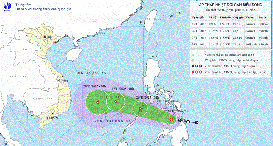
By 1:00 a.m. on November 27, the storm was moving at about 15-20 km/h in the central area of the East Sea, with the possibility of strengthening. Wind intensity was level 9-10, gusting to level 12. The affected area was in the middle of the East Sea and the northern sea area of the southern East Sea (including the northern sea area of Truong Sa special zone).
Warning: In the next 48 to 72 hours, the storm will move mainly to the West, at 10-15km per hour and will likely continue to strengthen.
In the North East Sea area, there are strong Northeast winds of level 6, sometimes level 7, gusting to level 8-9; Bach Long Vi station has strong Northeast winds of level 6, gusting to level 8; Phu Quy station has strong gusts of level 7.
Forecast for the day and night of November 25, in the North East Sea area (including Hoang Sa special zone), Northeast wind level 7, gusting to level 8-9. Rough sea; waves 4-6m high.
In the Gulf of Tonkin, the wind is at level 6 from the northeast, sometimes at level 7, gusting to level 8-9. The sea is rough; waves are 2-4m high. From South Quang Tri to Ca Mau and the western sea area of the Central East Sea, the wind is at level 6 from the northeast, sometimes at level 7, gusting to level 8-9. The sea is rough; waves are 3-5m high.
In the eastern sea area of the central East Sea, the wind will gradually increase to level 6-7, near the storm center it will increase to level 8, gusting to level 10. The sea will be rough; waves will be 3-5m high. In the central and southern East Sea area (including Truong Sa special zone) and the Gulf of Thailand, there will be scattered showers and thunderstorms; in the eastern sea area of the central East Sea, there will be rain in the evening and night of November 25. There is a possibility of tornadoes and strong gusts of wind during thunderstorms.
In the evening and night of November 25, in the northeastern sea area of the South China Sea, the wind gradually increased to level 6-7, gusting to level 9. The sea was rough; waves were 3-5m high.
Warning day and night 11/26, the North East Sea area (including Hoang Sa special zone) has strong Northeast wind level 7, sometimes level 8, gusting to level 9-10, waves 4-6m high, rough sea.
The Gulf of Tonkin has strong northeast winds of level 5, sometimes level 6, gusting to level 7-8, waves 2-4m high, rough seas.
The sea area from South Quang Tri to Ca Mau has strong northeast wind level 6, sometimes level 7, gusting to level 8-9, waves 3-5m high, rough sea.
The area between the East Sea and the northern sea area of the South East Sea (including the northern sea area of Truong Sa special zone) has strong winds of level 7, the area near the storm's eye has strong winds of level 9-10, gusts of level 12, waves 4-6m high. The sea is very rough.
The risk of natural disasters at sea is level 2, especially in the eastern sea area between the East Sea and the northeastern sea area of the southern East Sea, level 3.
It is forecasted that all vessels operating in the above areas are at high risk of being affected by strong winds and large waves.
Also according to the National Center for Hydro-Meteorological Forecasting, on the day and night of November 25, cold air will continue to affect other places in the Northeast and North Central regions, then affect the Northwest and North Central regions.
Source: https://baolangson.vn/rang-sang-26-11-ap-thap-nhiet-doi-co-kha-nang-vao-bien-dong-manh-len-thanh-bao-so-15-5065950.html


Comment (0)