With the initiative to build the "Dien Bien Water Resource Map," Senior Lieutenant Nguyen Doan Dat (Fire Prevention, Fire Fighting and Rescue Police Department - Dien Bien Provincial Police) has contributed to improving the effectiveness of fire fighting work, while at the same time arousing the spirit of creativity and innovation in the application of digital technology of the People's Police force.
Overcoming difficulties, serving the people
Born in 1997 (from Ha Tinh), after graduating from the Fire Prevention and Fighting University, in 2019, Nguyen Doan Dat started working at the Fire Prevention, Fighting and Rescue Police Department ( Dien Bien Provincial Police) since then.
Sharing about his profession, Dat confided that after more than 6 years working in a mountainous province, with an unsynchronized fire prevention infrastructure, firefighting in Dien Bien still encountered many difficulties. After directly participating in firefighting, he and his teammates had to "grope" to find water sources to put out the fire. This not only wasted time and slowed down the rescue process, but also affected the lives, health and property of the people.
According to statistics, from 2017 to 2023, in Dien Bien province, there were 83 fires that caused 4 casualties; causing property damage of over 20 billion VND. Of the 83 fires, about 90% of them required water to extinguish the fire. However, each fire truck can only carry 2-4 cubic meters of water, corresponding to a fire-fighting time of 2-4 minutes, after which the fire truck needs to continue to be supplemented from the available fire-fighting water supply.
Whenever a large fire occurs, in addition to mobilizing maximum machinery and equipment, the authorities need to quickly identify the on-site water source to speed up fire fighting and minimize damage caused by the fire.
The difficulties encountered in the practice of fire prevention have urged Senior Lieutenant Nguyen Doan Dat to ponder the idea of building a digital map software on water resources, to be proactive in serving fire fighting work. With that in mind, in February 2023, Dat "started" implementing the project to build the application "Dien Bien Water Resource Map" to serve fire fighting work.
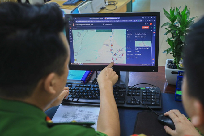
"The biggest difficulty in implementing the project was that my programming knowledge was limited. Therefore, to complete the work, I had to learn how to design software, create a database, build interfaces and access features. In addition, surveying water towers, reservoirs, ponds, streams, etc. in a large area like Dien Bien province took a lot of time and effort. Every day, in addition to the main time spent on professional work at the unit, I had to take advantage of my free time every evening or on weekends to complete the ideas I had cherished," Senior Lieutenant Dat shared.
After more than 4 months of diligent research, in June 2023, "Dien Bien Water Source Map" by Senior Lieutenant Nguyen Doan Dat was completed. The application has the function of supporting the search for the nearest water source location, displaying full information on flow, characteristics, operating status and especially the direction function, helping the fire prevention and fighting force to come up with the most effective approach plan.
All data is surveyed directly by Dat in the field, then located and integrated into Google Maps, synchronized to the server system, allowing flexible use on smartphones, tablets or desktops, serving promptly for all locations, from command centers to mobile firefighting teams.
Up to now, the software application "Dien Bien Water Source Map" has fully updated data of 260 public fire water sources that can be used for fire fighting in 10 districts, towns and cities of Dien Bien province.
Each fire prevention, firefighting and rescue officer and soldier is authorized to access and check information about water sources near the fire area, thereby planning to dispatch vehicles and coordinate to access water sources quickly and most appropriately.
Igniting passion for technology and creativity in the young generation
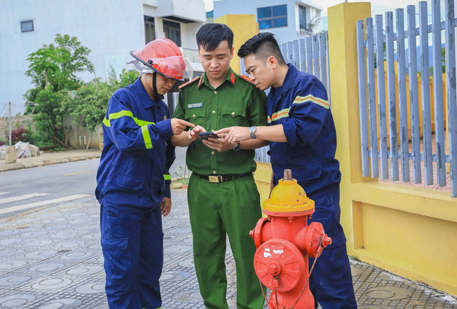
Driver Lo Van Tien, a soldier of the Fire Prevention, Fire Fighting and Rescue Police Department (Dien Bien Provincial Police) said that the application "Dien Bien Water Source Map" has helped him be more proactive in calculating the distance and route to control the fire truck to move to the location of the fire in the closest and most convenient way.
At the scene of the fire, the driver used the navigation feature to determine the nearest route to the location of the hydrant to replenish the firefighting water source, thereby helping officers and soldiers to be proactive in firefighting, contributing to improving the effectiveness of firefighting work, protecting people's lives and property.
Not only supporting fire fighting, the digital water source map that Senior Lieutenant Nguyen Doan Dat built is also an effective tool in fire prevention and urban infrastructure development policy consulting.
According to Lieutenant Colonel Nguyen Van Thuong, Deputy Head of the Fire Prevention, Fire Fighting and Rescue Police Department (Dien Bien Provincial Police), the application of digital technology in professional work is an inevitable trend of the police force in general and the fire prevention and fighting force in particular.
With the superiority of water source mapping software, in addition to helping the authorities review fire prevention and fighting, it is also possible to base on the location of existing water hydrants to make assessments and request investors to supplement appropriate water supply systems for each project.
"This map also plays a role in helping the staff department propose to the leaders of Dien Bien Provincial Police issues related to urban planning associated with fire prevention to ensure that the fire water supply system develops synchronously with residential infrastructure," emphasized Lieutenant Colonel Thuong.
Coming from a non-technological background as a firefighter, but with a spirit of serving the people, Senior Lieutenant Nguyen Doan Dat has shown the unceasing creativity of the People's Public Security youth in the digital transformation era.
His initiative not only improves the efficiency of professional work, but also spreads the spirit of innovation and application of technology to serve the community - something that the police force is encouraging and replicating throughout the force./.
Source: https://www.vietnamplus.vn/sang-kien-ban-do-nguon-nuoc-dien-bien-vu-khi-chong-giac-lua-post1041531.vnp






























































Comment (0)