

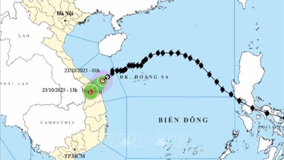
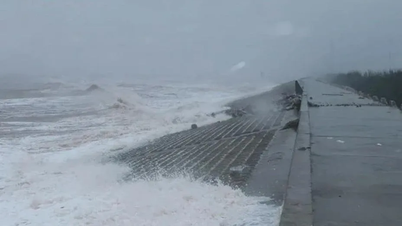
Forecast for today, October 23, heavy rain in the Central provinces (Photo: TL)
The National Center for Hydro-Meteorological Forecasting said today, October 23, the weather in the North, Thanh Hoa and Nghe An will have rain in some places. Cold at night and morning, some mountainous areas will be cold.
From Ha Tinh to Quang Ngai, there will be heavy rain and thunderstorms, from southern Quang Tri to Da Nang City, there will be heavy to very heavy rain. Due to the influence of storm circulation and cold air combined with easterly wind disturbances and terrain effects, from last night to October 24, there will be heavy rain and thunderstorms from Ha Tinh to Quang Ngai.
Rainfall is generally 100 - 250mm, locally very heavy rain over 350mm, especially in the area from southern Quang Tri to Da Nang city, heavy to very heavy rain with rainfall generally 400 - 600mm, some places over 800mm (heavy rain concentrated from the night of October 22 to the end of October 23). Warning of risk of rain intensity greater than 200mm/3 hours.
The South and other regions will have scattered showers and thunderstorms, with heavy rain in some places in the evening. Thunderstorms may include tornadoes, lightning, hail, and strong gusts of wind.
Regarding storm Than Gio, last night (October 22), after entering the sea area from Quang Tri to Quang Ngai, it weakened into a tropical depression. This morning the tropical depression will make landfall in our country.
At sea, the western sea area of the northern East Sea (including Hoang Sa special zone) has strong winds of level 7-8, the area near the storm's eye has strong winds of level 9-10, gusting to level 12. Waves are 3-5m high, the area near the storm's eye is 5-7m high, the sea is very rough.
The sea area from Quang Tri to Quang Ngai (including Con Co special zone, Cu Lao Cham island and Ly Son special zone) has strong winds of level 6-7, the area near the storm's eye has winds of level 8-9, gusts of level 11, waves 3-5m high, very rough seas.
While the tropical depression weakened from Typhoon Than Gio has not yet dissipated, a new tropical depression has formed in the sea east of Taiwan (China). This tropical depression is moving west-southwest and will enter the East Sea.
Detailed weather forecast today October 23:
Hanoi is cloudy, no rain. Cold at night and morning. Lowest temperature 19-21 degrees Celsius, highest 24-26 degrees Celsius.
Northwest region is cloudy, sunny during the day. Cold at night and morning, some places are cold. Lowest temperature 18-21 degrees Celsius, highest 25-28 degrees Celsius.
Northeast region is cloudy, rain in some places. Cold at night and morning, cold in mountainous areas. Lowest temperature 16-21 degrees Celsius, highest 24-27 degrees Celsius.
From Thanh Hoa to Hue, there will be moderate rain, heavy rain and thunderstorms, and very heavy rain in some places. Lowest temperature 20-23 degrees Celsius, highest 24-27 degrees Celsius.
South Central Coast heavy to very heavy rain. Lowest temperature 23-26 degrees Celsius, highest 29-32 degrees Celsius.
Central Highlands cloudy, scattered showers and thunderstorms, heavy rain in some places in the evening. Lowest temperature 19-22 degrees Celsius, highest 27-30 degrees Celsius.
The South is cloudy with scattered showers and thunderstorms, with heavy rain in some places in the evening. Lowest temperature 23-26 degrees Celsius, highest 31-34 degrees Celsius.
Ho Chi Minh City will be cloudy with scattered showers and thunderstorms, with heavy rain in some places in the evening. The lowest temperature is 24-26 degrees Celsius, the highest is 32-34 degrees Celsius./.

Weather forecast for today October 23 (Graphics: NGOC THANH)
According to Vietnam+
Source: https://tuoitre.vn/thoi-tiet-hom-nay-23-10-bao-than-gio-suy-yeu-thanh-ap-thap-nhiet-doi-gay-mua-rat-to-20251022184444478.htm
Source: https://baolongan.vn/thoi-tiet-hom-nay-23-10-bao-than-gio-suy-yeu-thanh-ap-thap-nhiet-doi-gay-mua-rat-to-a205049.html

![[Photo] Prime Minister Pham Minh Chinh chairs meeting on railway projects](https://vphoto.vietnam.vn/thumb/1200x675/vietnam/resource/IMAGE/2025/10/23/1761206277171_dsc-9703-jpg.webp)


![[Photo] President Luong Cuong holds talks with South African President Matamela Cyril Ramaphosa](https://vphoto.vietnam.vn/thumb/1200x675/vietnam/resource/IMAGE/2025/10/23/1761221878741_ndo_br_1-8416-jpg.webp)
![[Photo] Prime Minister Pham Minh Chinh meets with South African President Matamela Cyril Ramaphosa](https://vphoto.vietnam.vn/thumb/1200x675/vietnam/resource/IMAGE/2025/10/23/1761226081024_dsc-9845-jpg.webp)


Comment (0)