
The Hydrometeorological Agency forecasts that on the day and night of June 11, the South Central, Central Highlands and Southern regions will have moderate rain, heavy rain and thunderstorms, locally very heavy rain with common rainfall of 30-70mm, some places over 150mm.
From the night of June 11 to June 13, the Central Central region and the Northern Central Highlands will have moderate rain, heavy rain and thunderstorms, locally very heavy rain with common rainfall:
Central Central region from 100-300mm, some places over 450mm.
Northern Central Highlands region from 70-150mm, some places over 200mm.
Warning of risk of heavy localized rain (>200mm/6h).
From June 14, heavy rain in the above areas will decrease.
Thunderstorms may contain tornadoes, lightning, hail and strong winds.
Regarding the tropical depression at sea , at 1:00 a.m. on June 11, the center of the tropical depression was at about 15.5 degrees North latitude; 113.8 degrees East longitude, about 240km East Southeast of Hoang Sa archipelago. The strongest wind near the center of the tropical depression was level 7 (50-61km/h), gusting to level 9; moving slowly in the West Northwest direction at a speed of about 5-10km/h.
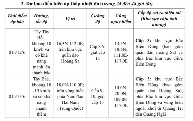 |
In the next 48 to 72 hours, the storm is likely to change direction and move to the North Northwest at a speed of about 10km/h.
 |
Forecast location and direction of tropical depression. |
Forecast of the impact of the tropical depression, the North East Sea area (including the sea area of Hoang Sa archipelago), the North of the Central East Sea area has thunderstorms and strong winds of level 6-7, then increasing to level 8-9, gusting to level 11, waves 2.5-4.5m high, very rough seas; the South of the Central East Sea area, the South East Sea area (including the sea area of Truong Sa archipelago) has strong southwest winds of level 6, sometimes level 7, gusting to level 8-9, waves 2.0-4.0m high, rough seas.
Ships operating in the above mentioned dangerous areas are likely to be affected by storms, whirlwinds, strong winds and large waves.
Weather forecast for day and night June 11:
Cloudy, sunny during the day, with occasional showers and thunderstorms in the evening and at night. North to Northwest wind level 2-3. During thunderstorms, there is a possibility of tornadoes, lightning and strong gusts of wind.
Lowest temperature: 24-26 degrees Celsius.
Highest temperature: 32-34 degrees Celsius.
Northwest
Cloudy, sunny during the day, showers and thunderstorms in the evening and at night. Light wind. During thunderstorms there is a possibility of tornadoes, lightning and strong gusts of wind.
Lowest temperature: 23-26 degrees Celsius, some places below 22 degrees Celsius.
Highest temperature: 31-34 degrees Celsius, some places above 34 degrees Celsius.
Northeast
Cloudy, sunny during the day, scattered showers and thunderstorms in the evening and at night. North to Northwest wind level 2-3. During thunderstorms, there is a possibility of tornadoes, lightning and strong gusts of wind.
Lowest temperature: 24-27 degrees Celsius, mountainous areas below 24 degrees Celsius.
Highest temperature: 31-34 degrees Celsius.
Thanh Hoa - Hue
In the North, it is cloudy with scattered showers and thunderstorms during the day, scattered showers and thunderstorms in the evening and at night. In the South, it is cloudy with scattered showers and thunderstorms during the day, locally heavy rain in some places, moderate rain, heavy rain and thunderstorms at night, locally very heavy rain in some places. Wind from the North to the Northwest is level 2-3. During thunderstorms, there is a possibility of tornadoes, lightning, hail and strong gusts of wind.
Lowest temperature: 23-26 degrees Celsius.
Highest temperature: North 31-34 degrees C, South 29-32 degrees C.
Da Nang - Binh Thuan
Cloudy, moderate to heavy rain, locally very heavy rain; in the North, there will be scattered showers and thunderstorms, locally heavy rain. West to southwest wind level 3-4, gusting to level 6-7 in some places. There is a possibility of tornadoes, lightning, hail and strong gusts of wind during thunderstorms.
Lowest temperature: 24-27 degrees Celsius.
Highest temperature: North 28-31 degrees Celsius, some places above 31 degrees Celsius.
Central Highlands
Cloudy, moderate to heavy rain and scattered thunderstorms, locally very heavy rain. Southwest wind level 3. Thunderstorms may cause tornadoes, lightning, hail and strong gusts of wind.
Lowest temperature: 20-23 degrees Celsius.
Highest temperature: 27-30 degrees Celsius.
Southern Vietnam
Cloudy, moderate to heavy rain and scattered thunderstorms, locally very heavy rain. Southwest wind level 3. Thunderstorms may cause tornadoes, lightning, hail and strong gusts of wind.
Lowest temperature: 24-27 degrees Celsius.
Highest temperature: 30-33 degrees Celsius.
Source: https://baophapluat.vn/thoi-tiet-ngay-116-mua-dong-bao-trum-trung-bo-tay-nguyen-va-nam-bo-post551399.html


Comment (0)