
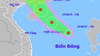
At 1:00 a.m. on June 26, the center of the tropical depression was at about 19.2 degrees North latitude; 111.8 degrees East longitude, about 130 km east of Hainan Island. The strongest wind near the center of the depression reached level 6 (39 - 49 km/h), gusting to level 8. The system is moving northwest at a speed of about 20 km/h.
It is forecasted that in the next 24 to 36 hours, the tropical depression will continue to move northwest and gradually shift to the north-northwest, traveling about 15 - 20km per hour. By 1:00 p.m. on June 27, the center of the tropical depression will be located on the mainland south of Guangxi province (China), at about 23.5 degrees north latitude; 108.5 degrees east longitude and is likely to weaken into a low pressure area.
The dangerous sea area in the next 24 hours is determined north of latitude 18 degrees north and from longitude 109 to 114 degrees east. The entire northwestern area of the East Sea is at level 3 natural disaster risk due to strong winds, high waves and dangerous thunderstorms.
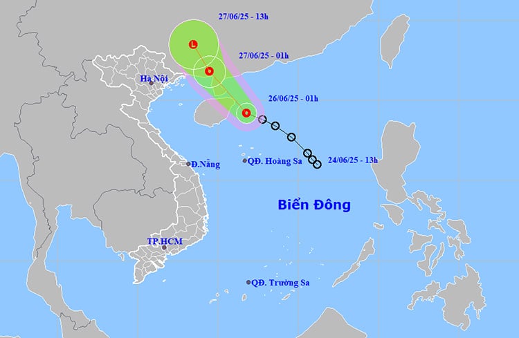 |
The path and location of the tropical depression on June 26. Photo: thoitietvietnam |
In this area, strong winds of level 6, gusting to level 8, rough seas, waves from 2 - 3.5m high, dangerous for ships and maritime activities. During thunderstorms, there is a high possibility of tornadoes and strong gusts of wind.
Due to the influence of the tropical depression, on the day and night of June 26, in the sea areas from the East Sea (including Hoang Sa and Truong Sa sea areas), the Gulf of Thailand, to the sea area from Binh Thuan - Ca Mau - Kien Giang, there will be showers and thunderstorms, accompanied by strong winds of level 6 - 7 during thunderstorms.
The National Steering Committee for Natural Disaster Prevention and Control recommends that coastal localities, especially the Northern and North Central regions, closely monitor developments of tropical depressions; proactively inspect and reinforce boats, aquaculture cages and rafts, and take measures to respond to heavy rains, floods and landslides.
On land, the influence of the tropical low pressure circulation caused heavy rains to continue in the North. From 7:00 p.m. on June 25 to 3:00 a.m. on June 26, the rainfall measured in many places exceeded 90mm, including very high points such as: Yen Bai 150.4mm, Phu Tho 115.2mm, Ha Giang 95.8mm, Son La 94.4mm.
On June 26, the North will have scattered showers and thunderstorms, locally heavy rain, rainfall from 10 - 30mm, some places over 80mm; in the Northwest and Viet Bac regions, some places will have very heavy rain, rainfall from 15 - 40mm, some places over 150mm.
The Central region (from Da Nang to Binh Thuan) also recorded scattered showers and thunderstorms, locally heavy rain from 10 - 30mm, some places over 70mm. In the Central Highlands and the South, there was moderate rain, heavy rain, some places very heavy rain, common rainfall from 15 - 40mm, some places over 100mm.
Due to prolonged heavy rains, mountainous areas in the North need to be on guard against the risk of flash floods and landslides on steep slopes, especially in provinces such as Yen Bai, Lao Cai, Ha Giang, Son La, and Lai Chau. At the same time, in low-lying urban areas, there is a risk of localized flooding.
Thunderstorms are likely to produce tornadoes, lightning, hail and strong gusts of wind over a wide area.
Weather forecast for regions across the country:
Hanoi capital is cloudy, sunny during the day, showers and thunderstorms in some places in the evening and at night. Southeast wind level 2 - 3. During thunderstorms, there is a possibility of tornadoes, lightning and strong gusts of wind. Lowest temperature 25 - 27 degrees Celsius. Highest temperature 21 - 33 degrees Celsius.
The Northwestern region is cloudy with scattered showers and thunderstorms; in the evening and at night there will be rain, moderate rain and thunderstorms, and locally heavy rain. Light wind. During thunderstorms, there is a possibility of tornadoes, lightning, hail, and strong gusts of wind. The lowest temperature is 23 - 26 degrees Celsius, in some places below 23 degrees Celsius. The highest temperature is 30 - 33 degrees Celsius, in some places above 33 degrees Celsius.
The northeastern provinces are cloudy with scattered showers and thunderstorms; in the mountainous and midland areas, in the late afternoon and at night, it is cloudy with rain, moderate rain and thunderstorms, with some places experiencing heavy to very heavy rain. Southeast wind level 2 - 3. During thunderstorms, there is a possibility of tornadoes, lightning, hail and strong gusts of wind. The lowest temperature is 25 - 28 degrees Celsius. The highest temperature is 30 - 33 degrees Celsius, in the mountainous areas, it is 27 - 29 degrees Celsius.
Provinces from Thanh Hoa to Hue will be cloudy, sunny during the day, with some places having hot weather; showers and thunderstorms in the evening and at night in some places. Light wind. During thunderstorms, there is a possibility of tornadoes, lightning and strong gusts of wind. Lowest temperature 25 - 28 degrees Celsius. Highest temperature 32 - 35 degrees Celsius, some places above 35 degrees Celsius.
From Da Nang to Binh Thuan, it is cloudy and sunny during the day; showers and thunderstorms in some places in the afternoon and evening. Southwest wind level 2 - 3. During thunderstorms, there is a possibility of tornadoes, lightning and strong gusts of wind. Lowest temperature 24 - 27 degrees Celsius. Highest temperature 32 - 35 degrees Celsius.
The Central Highlands provinces are cloudy with scattered showers and thunderstorms, with scattered showers and thunderstorms in the afternoon and evening, with some heavy rain in some places. Southwesterly winds level 2-3. There is a possibility of tornadoes, lightning and strong gusts of wind during thunderstorms. Lowest temperature 21-24 degrees Celsius. Highest temperature 27-30 degrees Celsius.
The South is cloudy, with scattered showers and thunderstorms in the morning and some places in the West; showers and thunderstorms in some places later; scattered showers and thunderstorms in the afternoon and evening, with heavy rain in some places. Southwesterly wind level 2 - 3. There is a possibility of tornadoes, lightning and strong gusts of wind during thunderstorms. Lowest temperature 23 - 26 degrees Celsius. Highest temperature 29 - 32 degrees Celsius.
Source: https://huengaynay.vn/chinh-tri-xa-hoi/thoi-weather-ngay-26-6-ap-thap-nhiet-doi-tren-bien-dong-gay-mua-lon-dien-rong-155052.html

![[Photo] Cuban artists bring "party" of classic excerpts from world ballet to Vietnam](https://vphoto.vietnam.vn/thumb/1200x675/vietnam/resource/IMAGE/2025/6/26/797945d5d20b4693bc3f245e69b6142c)


![[Photo] General Secretary To Lam receives Australian Ambassador to Vietnam Gillian Bird](https://vphoto.vietnam.vn/thumb/1200x675/vietnam/resource/IMAGE/2025/6/26/ce86495a92b4465181604bfb79f257de)


Comment (0)