
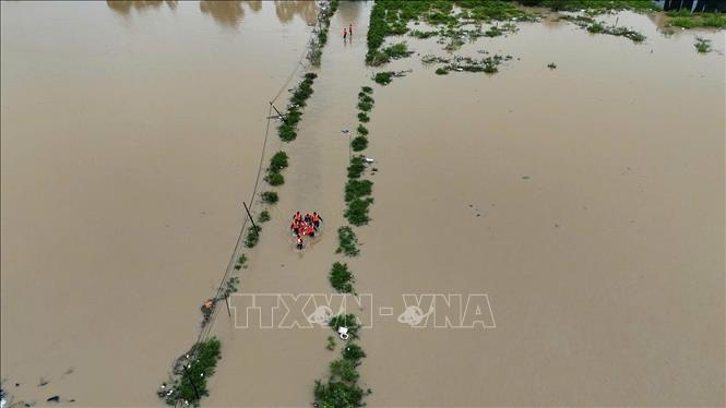
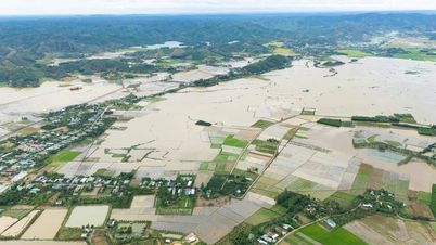
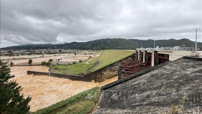
Heavy rains caused floodwaters to rise rapidly on rivers. The water level at 6 a.m. on November 20 on Dinh Ninh Hoa River at Duc My station was 17.66 meters, 0.16 meters above alert level 3; Ninh Hoa hydrological station was 6.66 meters, 0.96 meters above alert level 3 (0.08 meters above the historical flood of 1986).
On Cai Nha Trang river at Dong Trang hydrological station, the water level is 13.14 meters, 2.14 meters above alert level 3 (historic flood was 13.42 meters on November 3, 2009). On Cai Phan Rang river, the water level measured at Tan My hydrological station is 39.64 meters, 2.14 meters above alert level 3; Phan Rang hydrological station is 4.73 meters, 0.23 meters above alert level 3.
According to the forecast of the authorities, from November 20-22, floods on rivers will continue to rise. The flood peak on Dinh Ninh Hoa river at Ninh Hoa station is at alert level 3 from 1.0 - 1.3 meters and higher than the historical flood in 1986 (6.58 meters) from 0.12 - 0.42 meters (flood peak from 6.7-7 meters); Cai Nha Trang river at Dong Trang hydrological station is above alert level 3 from 2.2-2.4 meters (historic flood was 13.42 meters on November 3, 2009); at Dien Phu station is above alert level 3 from 1.2-1.4 meters.
Forecast on Cai Phan Rang river at Tan My station is above alarm level 3 from 2.2-2.7 meters (historical flood was 41.21 meters on November 13, 2003); at Phan Rang station is above alarm level 3 from 0.4-1.0 meters (historical flood was 5.38 meters on November 13, 2003).
Khanh Hoa Province's Hydrometeorological Station also forecasted the peak water level of Dinh Ninh Hoa River from 7am to 10am on November 20, and on Cai Nha Trang River and Cai Phan Rang River from 10am to 4pm on November 20.
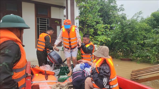
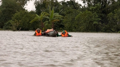
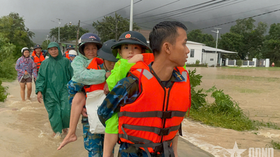
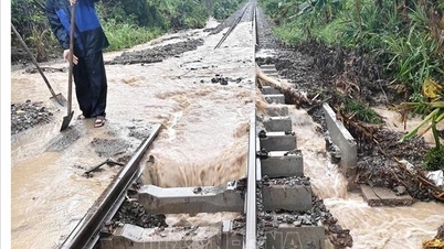
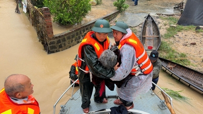
Along with flooding, Khanh Hoa province is at risk of flash floods and landslides on overflow roads, small rivers and streams: Khanh Le pass connecting Nha Trang - Da Lat, National Highway 27C, mountain slopes along Provincial Road 9, mountain slopes along Dong Khanh Son commune road, Vinh Hy - Binh Tien road, Ninh Hai, along Nguyen Tat Thanh Avenue, etc. High-risk communes are: Van Hung, Van Thang, Dai Lanh, Tay Ninh Hoa, Dong Ninh Hoa, Nha Trang, Bac Nha Trang, Tay Nha Trang, Nam Nha Trang, Suoi Hiep, Cam Lam, Cam An, Suoi Dau, Cam Hiep, Nam Cam Ranh, Bac Khanh Vinh, Tay Khanh Vinh, Trung Khanh Vinh, Nam Khanh Vinh, Khanh Vinh, Khanh Son, Dong Khanh Son, Lam Son, Bac Ai Tay, Bac Ai, Bac Ai Dong, My Son, Phuoc Dinh, Ca Na, Cong Hai, Thuan Bac, Vinh Hai also need to be on guard against landslides.
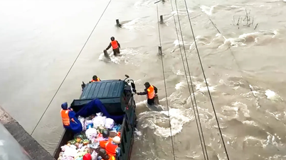
In addition, the following localities: Ninh Hoa, Tan Dinh, Hoa Thang, Nam Ninh Hoa, Dien Khanh, Dien Dien, Dien Lac, North Nha Trang, Nha Trang, West Nha Trang, South Nha Trang, Phan Rang, Vinh Hy, Bao An, Ninh Chu, Dong Hai, Ninh Hai, Ninh Phuoc, Thuan Nam have flooding.
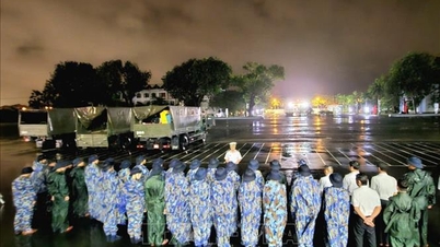
Authorities also warned that reservoir regulation needs to pay attention to dam safety. It is necessary to take advantage of the time when the weather has not yet affected to have a plan to release water from the reservoir to ensure the safety of the reservoir and downstream areas, etc.
Previously, the total rainfall from November 16 to 6:00 a.m. on November 20 was generally from 200 - 400mm in many places, especially in the mountainous areas of Khanh Son and Khanh Vinh, it was generally 400 - 600mm, with some stations receiving more than 800mm of rain, such as Khanh Hiep 994.7mm, Son Thai 834.5mm, and Cam Phuoc Dong station 866.6mm.
Source: https://baotintuc.vn/xa-hoi/tiep-tuc-co-mua-lon-lu-tren-cac-song-dang-len-o-khanh-hoa-20251120072035445.htm

![[Photo] Lam Dong: Panoramic view of Lien Khuong waterfall rolling like never before](/_next/image?url=https%3A%2F%2Fvphoto.vietnam.vn%2Fthumb%2F1200x675%2Fvietnam%2Fresource%2FIMAGE%2F2025%2F11%2F20%2F1763633331783_lk7-jpg.webp&w=3840&q=75)
![[Photo] National Assembly Chairman Tran Thanh Man holds talks with South Korean National Assembly Chairman Woo Won Shik](/_next/image?url=https%3A%2F%2Fvphoto.vietnam.vn%2Fthumb%2F1200x675%2Fvietnam%2Fresource%2FIMAGE%2F2025%2F11%2F20%2F1763629724919_hq-5175-jpg.webp&w=3840&q=75)

![[Photo] President Luong Cuong receives President of the Senate of the Czech Republic Milos Vystrcil](/_next/image?url=https%3A%2F%2Fvphoto.vietnam.vn%2Fthumb%2F1200x675%2Fvietnam%2Fresource%2FIMAGE%2F2025%2F11%2F20%2F1763629737266_ndo_br_1-jpg.webp&w=3840&q=75)


Comment (0)