

According to the latest assessment of the National Center for Hydro-Meteorological Forecasting (Department of Hydro-Meteorology, Ministry of Agriculture and Environment ), in the next 30 days, there is a possibility of dangerous weather phenomena appearing nationwide, negatively affecting traffic activities, production and public health.
Specifically, on November 11, expert Tran Thi Chuc - Deputy Head of Climate Forecasting Department (National Center for Hydro-Meteorological Forecasting, Department of Hydro-Meteorology) said that from now until December 10, the average temperature in the Northeast region and provinces and cities from Thanh Hoa to Da Nang , the East of Quang Ngai province will generally be 0.5-1 degree Celsius lower than the average of many years; the remaining areas will be 0.5 degree Celsius lower.
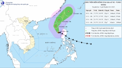
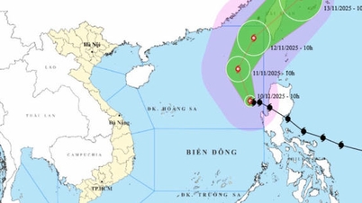
Notably, the East Sea region is likely to see 1-2 storms and tropical depressions that may affect the mainland (on average, over many years, 1.2 storms and tropical depressions appear in the East Sea; 0.4 storms make landfall).
Regarding cold air, expert Tran Thi Chuc said that during the forecast period, cold air will continue to increase in frequency and intensity.
According to the National Center for Hydro-Meteorological Forecasting, from now until December 10, provinces and cities from the south of Quang Tri to Da Nang, the east of Quang Ngai to Dak Lak and Khanh Hoa are likely to experience widespread heavy rains. The Central Highlands and the South may experience a few showers and thunderstorms, concentrated in the period of November 2025.
Total rainfall in the Northern region and provinces from Thanh Hoa to the North of Quang Tri province is forecast to be 10-30% lower than the average of many years; total rainfall in the remaining areas is 10-30% higher than the average of many years. Particularly in the South of Quang Tri to Lam Dong, total rainfall is likely to be 30-60% higher than the average of many years in the same period.
In addition, nationwide, there is still the possibility of dangerous weather phenomena such as thunderstorms, tornadoes, lightning, hail and strong gusts of wind.
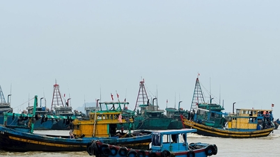
With the above meteorological developments, the National Center for Hydro-Meteorological Forecasting warns that storms, tropical depressions and cold air can cause strong winds, large waves at sea and affect the activities of ships.
In addition, heavy rains, thunderstorms, tornadoes and lightning can negatively affect traffic, production and public health. People in the above areas need to be on guard against heavy rains, especially in the Central region, which can cause flooding in low-lying areas and landslides in mountainous areas.
In the context of climate change, complex weather developments with many dangerous and extreme forms (such as heavy rain in a short period of time, flash floods, landslides), the national hydrometeorological agency also recommends that authorities at all levels and people regularly update and integrate hydrometeorological forecast and warning information in short-term bulletins of 1-3 days, to promptly adjust production plans and appropriate response plans.
In particular, local authorities need to pay attention to appropriate reservoir operation plans, ensuring safety of works and downstream areas, as well as ensuring safety for production activities and people's lives.
According to VNASource: https://baohaiphong.vn/tu-nay-den-giua-thang-12-kha-nang-xuat-hien-1-2-con-bao-ap-thap-nhiet-doi-526343.html


![[Photo] Prime Minister Pham Minh Chinh receives Lao Minister of Labor and Welfare Phosay Sayasone](https://vphoto.vietnam.vn/thumb/1200x675/vietnam/resource/IMAGE/2025/11/11/1762872028311_dsc-2246-jpg.webp)
![[Photo] Chu Noodles - the essence of rice and sunshine](https://vphoto.vietnam.vn/thumb/1200x675/vietnam/resource/IMAGE/2025/11/11/1762846220477_ndo_tl_7-jpg.webp)


![Dong Nai OCOP transition: [Article 3] Linking tourism with OCOP product consumption](https://vphoto.vietnam.vn/thumb/402x226/vietnam/resource/IMAGE/2025/11/10/1762739199309_1324-2740-7_n-162543_981.jpeg)


Comment (0)