
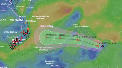
Updated information as of the afternoon of November 24 from the National Center for Hydro-Meteorological Forecasting, the center of the tropical depression has moved to coordinates of about 9.6 degrees North latitude - 126.5 degrees East longitude, located on the eastern coastal area of the central Philippines. The strongest wind in the area near the center of the tropical depression is level 7 (50-61 km/h), gusting to level 9. The tropical depression moves in the West Northwest direction at a speed of about 20 km/h.

Vietnam's Hydrometeorological Agency said that from the afternoon of November 24 to the afternoon of November 25, the tropical depression will move in a West-Northwest direction at a speed of about 20-25km/hour, entering the central Philippines with strong winds of level 7, gusting to level 9.
From the afternoon of November 25 to 26, the tropical depression changed direction to the West with a speed of about 20-25km/hour, entering the East Sea (possibly strengthening into a level 8 storm, gusting to level 10).
The National Center for Hydro-Meteorological Forecasting said that around the afternoon of November 26, the storm's center was located in the sea northeast of Truong Sa special zone. After that, the storm moved mainly westward, traveling about 15km per hour and had the potential to strengthen.
According to the meteorological agency's warning, from the evening of November 25, the eastern sea of the central and southern East Sea will have winds gradually increasing to level 6-7, near the storm center will have strong winds of level 8, gusting to level 10, with waves 3-5m high.
From the night of November 26 to the night of November 28, the central and southern East Sea (including the sea area north of Truong Sa special zone) is likely to be affected by strong winds of level 9-10, gusting to level 13.

In response to the forecast that the tropical depression is likely to enter the East Sea and is at risk of strengthening into a storm, on the same day, November 24, the National Civil Defense Steering Committee sent a telegram to the People's Committees of coastal provinces and cities from Quang Tri to An Giang and related ministries, requesting them to proactively respond to the tropical depression (storm).
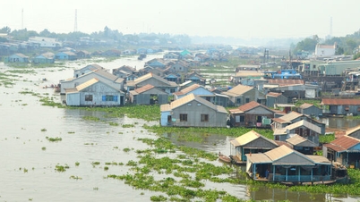
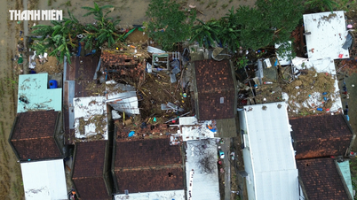
In the dispatch, the National Steering Committee for Civil Defense stated that the tropical depression tends to move into the southeast sea area of the central East Sea, towards the central region - which has suffered serious damage due to floods in recent days and is likely to strengthen into a storm.
To proactively respond to the tropical depression that is likely to strengthen into a storm in the context that the Central region is continuing to overcome the consequences of recent severe rains and floods, the National Steering Committee for Civil Defense requested the provinces in the South Central region to urgently focus on overcoming the consequences, restoring production and business, and stabilizing people's lives after the recent historic rains and floods according to Official Dispatch No. 227/CD-TTg dated November 23, 2025 of the Prime Minister ; be ready to prepare to respond to the next natural disaster.
The Steering Committee also requested localities to notify captains and owners of vehicles and vessels operating at sea to proactively prevent and have appropriate production plans, ensure safety of people and property, and maintain communication to promptly handle bad situations that may occur.
Along with that, localities and ministries and branches are on duty seriously, readying forces and means to deploy rescue work when there is a situation.
Source: https://www.sggp.org.vn/ung-pho-ap-thap-nhiet-doi-co-kha-nang-thanh-bao-post825209.html


![[Photo] Prime Minister Pham Minh Chinh attends the patriotic emulation congress of the banking sector](/_next/image?url=https%3A%2F%2Fvphoto.vietnam.vn%2Fthumb%2F1200x675%2Fvietnam%2Fresource%2FIMAGE%2F2025%2F11%2F24%2F1763981997729_tt-nhnn-jpg.webp&w=3840&q=75)
![[Photo] National Assembly Chairman Tran Thanh Man receives a business delegation from the Europe-ASEAN Business Council](/_next/image?url=https%3A%2F%2Fvphoto.vietnam.vn%2Fthumb%2F1200x675%2Fvietnam%2Fresource%2FIMAGE%2F2025%2F11%2F24%2F1763989198212_ndo_br_bnd-7394-jpg.webp&w=3840&q=75)

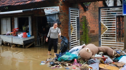


![[Photo] Next to the "mountain of trash" after the flood, Tuy Hoa residents strive to rebuild their lives](/_next/image?url=https%3A%2F%2Fvphoto.vietnam.vn%2Fthumb%2F1200x675%2Fvietnam%2Fresource%2FIMAGE%2F2025%2F11%2F24%2F1763951389752_image-1-jpg.webp&w=3840&q=75)


Comment (0)