It is forecasted that in the next 24 hours, the low pressure area is likely to strengthen into a tropical depression.
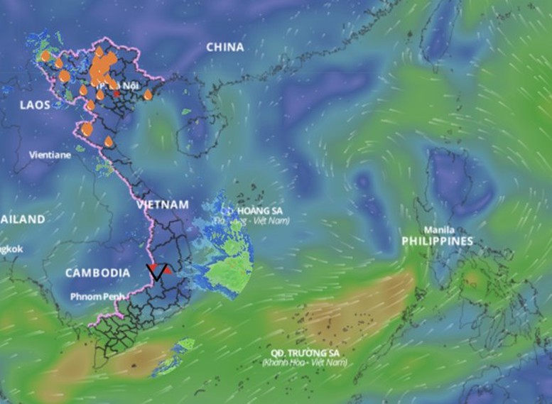
According to the National Center for Hydro-Meteorological Forecasting, this morning (June 9), a low pressure area appeared in the North East Sea, located at 7:00 a.m. at about 17.0-18.0 degrees North latitude, 117.2-118.2 degrees East longitude. This low pressure area is located on a low pressure trough with an axis of about 15-18 degrees North latitude and is moving slowly in a westerly direction.
It is forecasted that in the next 24 hours, the low pressure area is likely to strengthen into a tropical depression, with a probability of 80-90%. After that, the tropical depression is expected to move northwest, that is, north of the Hoang Sa archipelago sea area and is likely to continue strengthening into a storm in the next 48-72 hours (from June 12-13) with a probability of about 60-70%.
Currently, the low pressure area is still in the formation stage and has not yet developed into a tropical depression. The dominant atmospheric systems such as the southwest monsoon, subtropical high pressure... are still fluctuating and unstable, making the trajectory and intensity of this system still potentially uncertain.
Based on current forecast models, the tropical depression and storm (if formed) are likely to affect the northern part of the East Sea, including the waters of the Paracel Islands, and even some areas in the eastern and central parts of the Gulf of Tonkin in extreme cases. However, the actual developments will depend on the further developments in the next 1-2 days.
During the day and night of June 9, many coastal areas will have dangerous weather.
The North East Sea (including the Hoang Sa archipelago), the Central and South East Sea (including the Truong Sa archipelago), the sea from Binh Dinh to Ca Mau , Ca Mau to Kien Giang and the Gulf of Thailand will have showers and strong thunderstorms. During thunderstorms, there is a possibility of tornadoes, strong gusts of wind of level 6-7, and waves over 2.0m high.
The sea area from Ninh Thuan to Ca Mau, the middle and southern East Sea has strong southwest winds of level 5, sometimes level 6, gusting to level 7-8, rough seas, waves from 1.5-3.0m high.
All vessels operating in the above areas should pay special attention to the high risk of tornadoes, strong winds and large waves.
Disaster risk level due to strong winds at sea: Level 1.
TS
Source: https://baothanhhoa.vn/vung-ap-thap-tren-bien-dong-co-kha-nang-manh-len-thanh-bao-251524.htm


Comment (0)