

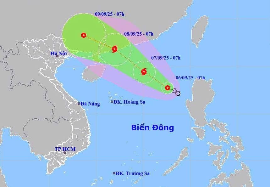
It is forecasted that in the next 24 hours, the tropical depression will continue to move northwest at a speed of 10-15km/hour, with the potential to strengthen into a storm.
At 7:00 a.m. on September 7, the center of the storm was at about 19.4 degrees north latitude, 115.1 degrees east longitude, about 430km northeast of Hoang Sa archipelago with strong winds of level 8, gusting to level 10.
The storm continues to move northwest at a speed of about 15km/h and is still gaining strength.
At 7:00 a.m. on September 8, the center of the storm was at about 21.8 degrees north latitude, 112 degrees east longitude, in the coastal area of Guangdong province (China) with the strongest wind at level 9, gusting to level 11.
Due to the influence of a tropical depression that is likely to strengthen into a storm, the northeastern sea area of the East Sea will have strong winds of level 6, later increasing to level 7-8, gusting to level 10; waves 2-4m high, rough seas.
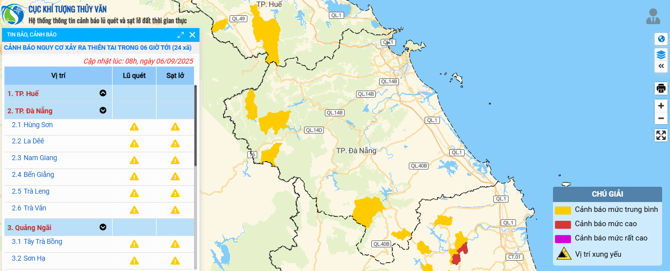
In addition, during the day and night of September 6, the area from Da Nang to Lam Dong will have moderate rain, thunderstorms, locally heavy to very heavy rain with rainfall of 20-40mm, some places over 100mm, rain concentrated in the afternoon and night.
Thunderstorms may cause tornadoes, lightning, hail, and strong gusts of wind. Localized heavy rain may cause flash floods, landslides, and inundation of low-lying areas.
To proactively respond to natural disasters, the Da Nang City Civil Defense Command has issued a document requesting the City Military Command, the City Border Guard Command, the Department of Agriculture and Environment, and the People's Committees of coastal communes and wards to organize on-duty shifts; closely monitor warning bulletins, forecasts and developments of tropical depressions.
At the same time, notify captains, owners of vehicles and ships operating at sea to proactively prevent and adjust production plans to ensure safety of people and property...
Along with that, maintain communication to promptly handle situations that may arise. Prepare forces and means to deploy response work when situations arise.
Source: https://baodanang.vn/ap-thap-nhiet-doi-o-dong-bac-bien-dong-da-nang-se-co-mua-vua-mua-to-3301174.html

![[Photo] Politburo works with the Standing Committees of Dong Thap and Quang Tri Provincial Party Committees](https://vphoto.vietnam.vn/thumb/1200x675/vietnam/resource/IMAGE/2025/9/8/3e1c690a190746faa2d4651ac6ddd01a)
![[Photo] Politburo works with the Standing Committees of Vinh Long and Thai Nguyen Provincial Party Committees](https://vphoto.vietnam.vn/thumb/1200x675/vietnam/resource/IMAGE/2025/9/8/4f046c454726499e830b662497ea1893)


![[Photo] Amazing total lunar eclipse in many places around the world](https://vphoto.vietnam.vn/thumb/1200x675/vietnam/resource/IMAGE/2025/9/8/7f695f794f1849639ff82b64909a6e3d)


Comment (0)