
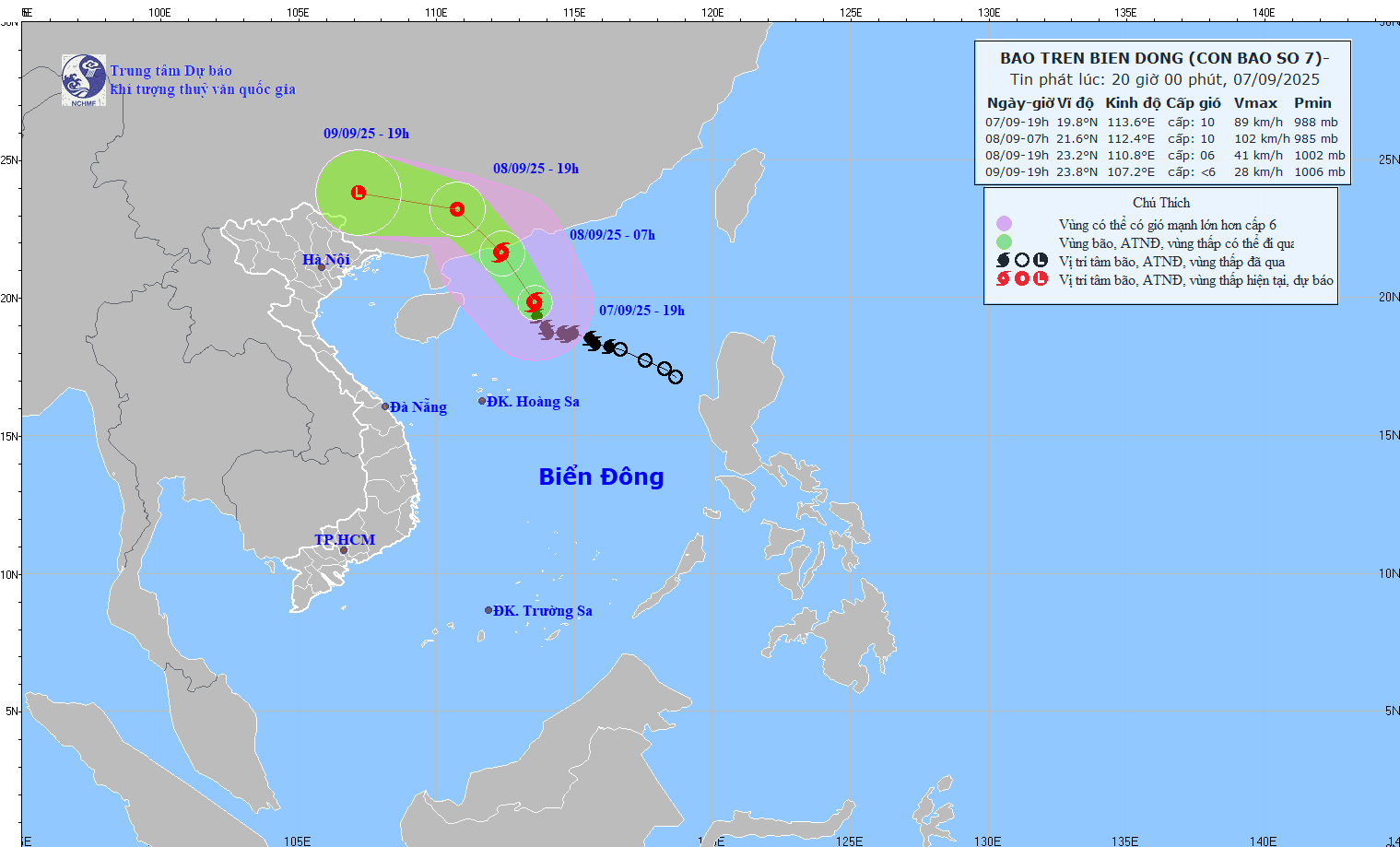
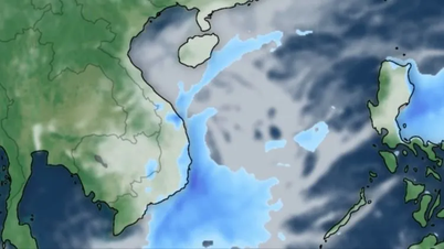
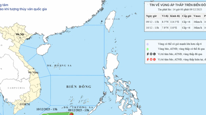
According to the National Center for Meteorological and Hydrological Forecasting, at 7 PM on September 7th, the typhoon's center was located at approximately 19.8 degrees North latitude and 113.6 degrees East longitude, in the northern part of the South China Sea. The strongest winds near the center of the typhoon were at level 9-10 (75-102 km/h), with gusts up to level 13. It was moving in a North-Northwest direction at a speed of 15-20 km/h.
Forecasts indicate that by 7:00 AM on September 8th, the storm will be located in the coastal waters south of Guangdong province (China), moving in a north-northwest direction at approximately 20 km/h with wind speeds of level 10, gusting to level 13. The affected area is the northern part of the South China Sea. The level of natural disaster risk is level 3.
As of 7 PM on September 8th, the storm was over land in southern Guangdong province (China), moving northwest at approximately 20 km/h. Wind speeds reached level 6, with gusts up to level 8. The affected area is the northwestern part of the North East Sea. The level of natural disaster risk is level 3.
By 7 PM on September 9th, the storm was over land in Guangxi Province (China); moving in a west-northwest direction at a speed of approximately 15-20 km/h, weakening into a low-pressure area. Wind speeds were below level 6.
Due to the impact of the storm, the northern part of the North East Sea region is experiencing strong winds of force 7-8, with winds near the storm's center reaching force 9-10, gusting to force 13; waves are 4-6 meters high, and the sea is very rough. Vessels operating in these dangerous areas are likely to be affected by thunderstorms, tornadoes, strong winds, and high waves.
"Although not directly affected by the storm's circulation, areas on the far edge of the storm's circulation, such as the Gulf of Tonkin and the eastern coastal areas of Northern Vietnam, may experience thunderstorms, tornadoes, and strong gusts of wind," noted Hoang Phuc Lam, Deputy Director of the National Center for Meteorological and Hydrological Forecasting.
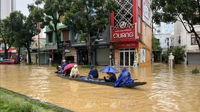
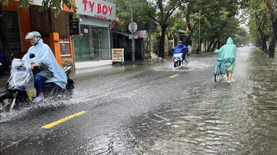
In addition, according to the National Center for Meteorological and Hydrological Forecasting, from 7:30 PM on September 7th to 12:30 AM on September 8th, the provinces of Gia Lai, Dak Lak , Lam Dong, and Khanh Hoa will continue to experience rain with accumulated rainfall generally ranging from 10-30mm, and in some places exceeding 60mm.
Warning of the risk of flash floods on small rivers and streams, and landslides on slopes in many communes/wards: Chư Pưh, Chư Sê, Ia Ko, Ia Lâu, Ia Le, Ia Pia, Ia Pnôn, Ia Púch, Ia Tôr, Phú Túc ( Gia Lai province); Ea Păl; Cư Pui, Cư Yang, Đắk Liêng, Ea Knuếc, Ea Ô, Hòa Phú, Yang Mao; Cư M'ta, Cư Prao, Cuôr Đăng, Đồng Xuân, Ea Kar, Ea Knốp, Ea Nuôl, Hòa Thịnh, Hòa Xuân, Krông Á, Krông Ana, Krông Nô, M'Drắk, Đông Hòa Ward, Tân An Ward, Quảng Phú, Tây Sơn, Xuân Phước (Đắk Lắk province); Tây Ninh Hòa; Bac Ai, Cong Hai, Dien Dien, Dien Khanh, Dien Lac, Dien Lam, Dien Tho, Khanh Vinh, My Son, Nam Khanh Vinh, Ninh Son, Bac Cam Ranh, Cam Ranh, Nam Nha Trang, Tay Nha Trang, Tay Khanh Vinh, Trung Khanh Vinh, Van Ninh, Van Thang (Khanh Hoa province); Tay Ninh Hoa; Bac Ai, Cong Hai, Dien Dien, Dien Khanh, Dien Lac, Dien Lam, Dien Tho, Khanh Vinh, My Son, Nam Khanh Vinh, Ninh Son, Bac Cam Ranh, Cam Ranh, Nam Nha Trang, Tay Nha Trang, Tay Khanh Vinh, Trung Khanh Vinh, Van Ninh, Van Thang (Lam Dong province).
Level 1 natural disaster risk due to flash floods, landslides, and land subsidence caused by heavy rain or runoff. Flash floods and landslides can have very serious impacts on the environment, threaten people's lives; cause localized traffic congestion, affecting the movement of vehicles; destroy public and economic infrastructure, causing damage to production and socio-economic activities.
The meteorological and hydrological agency recommends that local authorities pay attention to reviewing bottlenecks and vulnerable locations in the area to take preventive and response measures.
From 4 PM to 6 PM on September 7th, moderate to heavy rain fell in the provinces of Gia Lai, Dak Lak, Lam Dong, and Khanh Hoa, with rainfall amounts such as: Chu Ngoc (Gia Lai) 50.2mm; Ca Lui (Dak Lak) 34.4mm; Ninh Tay (Khanh Hoa) 77.4mm; Da Quyn 49.4mm (Lam Dong);...
Soil moisture models indicate that some areas in these provinces are near saturation (above 85%) or have reached saturation.
PV (compiled)Source: https://baohaiphong.vn/bao-gay-song-lon-tren-vung-bien-phia-bac-khu-vuc-bac-bien-dong-520205.html


Comment (0)