
Da Nang is experiencing moderate rain, with some areas receiving heavy to very heavy rain.
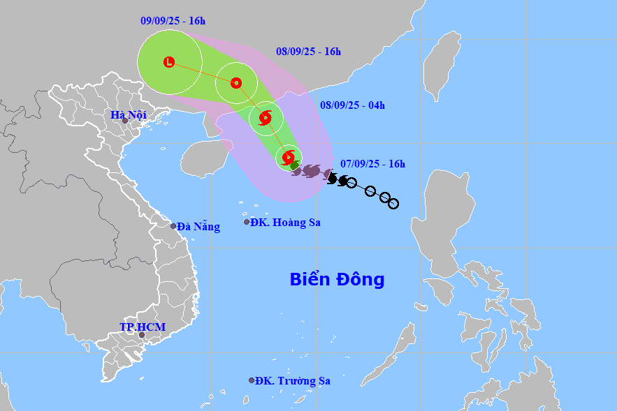
According to the National Center for Hydro-Meteorological Forecasting, over the next 24 hours, Typhoon No. 7 in the northern part of the South China Sea (with maximum wind speeds of level 9-10, gusts up to level 13) is moving northwest at a speed of 10-15 km/hour.
As of 4:00 AM on September 8th, the typhoon's center was located at approximately 21.2 degrees North latitude and 112.6 degrees East longitude, about 180km southwest of Macau (China), with maximum wind speeds of level 10, gusting to level 13.
The storm continued to move northwest at a speed of about 20 km/hour into the mainland of Guangdong province (China) and gradually weakened.
As of 4 PM on September 8th, the typhoon's center was located at approximately 22.9 degrees North latitude and 111.2 degrees East longitude, over land in southern Guangdong province (China), with maximum wind speeds of level 7, gusting to level 9.
Although not directly affected by the storm's circulation, areas on the far edge of the storm's circulation, such as the Gulf of Tonkin and the eastern coastal areas of Northern Vietnam, may experience thunderstorms, tornadoes, and strong gusts of wind.
Due to the influence of the tropical convergence zone connected to typhoon No. 7, during the night of September 7th and the day of September 8th, the southern area of the northern South China Sea (including the Hoang Sa Special Economic Zone) will experience strong winds of level 6, gusting to levels 7-8, rough seas, and waves 2-4 meters high.
In the central area of the South China Sea, there are strong winds of force 5, sometimes force 6, gusting to force 7-8, rough seas, and waves 2-3 meters high.
Additionally, scattered showers and thunderstorms are expected in the southern part of the North East Sea (including the Hoang Sa Special Zone), the central and southern parts of the East Sea (including the Truong Sa Special Zone), the sea area from southern Quang Tri to Ca Mau, from Ca Mau to An Giang , and the Gulf of Thailand; during thunderstorms, there is a possibility of tornadoes, strong gusts of wind at level 6-7, and waves over 2 meters high.
During the evening and night of September 7th, the area from Da Nang city to Lam Dong and the Southern region experienced rain, moderate rain, and scattered thunderstorms, with some areas experiencing heavy to very heavy rain. The rainfall amount was generally 20-40mm, with some areas receiving over 100mm.
There is a risk of rainfall exceeding 80mm in 3 hours; thunderstorms may bring tornadoes, lightning, hail, and strong gusts of wind.
Localized heavy rainfall can cause flooding in low-lying areas, urban and industrial zones; flash floods on small rivers and streams; and landslides on slopes.
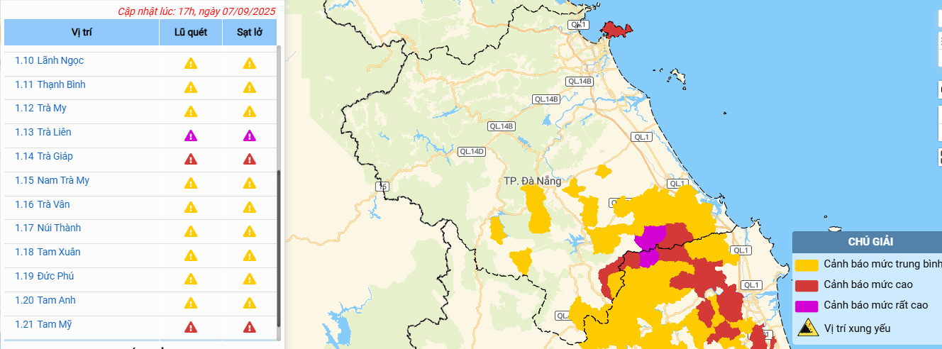
Proactive response to localized heavy rainfall.
To proactively respond to Typhoon No. 7 and localized thunderstorms and heavy rains, and to minimize damage caused by natural disasters, the City Civil Defense Command continues to issue documents requesting the City Military Command, the City Border Guard Command, the Department of Agriculture and Environment, and the People's Committees of coastal communes and wards to organize the counting and assessment.
Simultaneously, inform owners and captains of vessels operating at sea about the location, direction of movement, and development of the storm so that they can proactively take precautions, evacuate, or avoid moving into dangerous areas.
The management board and investors of ongoing construction projects are ready to implement plans to prevent damage from heavy rain to the projects, measures to prevent flooding, and clear drainage channels for residential areas affected by the unfinished construction.
The Department of Construction will take the lead and coordinate with relevant units to implement plans for flood prevention and control, and clearing drainage ditches.
The Department of Agriculture and Environment continues to organize inspections and provide guidance to localities and units to ensure the safety of agricultural production activities, and to expedite the harvesting of summer-autumn rice crops, vegetables, and agricultural and aquatic products that are ready for harvest in order to minimize damage caused by heavy rain and flooding.
The Department of Culture, Sports and Tourism and local authorities are providing information on the natural disaster situation to tourism units, offices, infrastructure facilities, and tourists. Tourist areas and outdoor entertainment venues are required to ensure the safety of tourists and infrastructure in the event of a natural disaster.
The People's Committees of communes and wards should review and proactively deploy rapid response forces to inspect and survey residential areas along rivers and streams, low-lying areas at risk of flooding, flash floods, and landslides, in order to proactively clear waterways. They should also relocate and evacuate residents to safe areas.
Organize forces to guard, control, support, and guide traffic to ensure safety for people and vehicles, especially at underpasses, overflows, areas with deep flooding, areas with strong currents, on rivers and streams, and areas where landslides have occurred or are at risk of occurring.
Strictly prohibit people and vehicles from passing through if safety cannot be guaranteed. Deploy personnel, supplies, and equipment to address incidents and ensure smooth traffic flow on major transportation routes during heavy rain.
Local authorities and units managing irrigation and hydropower reservoirs should continue to monitor forecast and warning bulletins, reservoir water level developments, and organize reservoir operation and regulation in accordance with the procedures approved by competent authorities.
Maintain safety inspections of dams and reservoirs; coordinate with local authorities to regularly inspect and prevent people and vehicles from entering the reservoir and spillway. Promptly notify downstream localities when water levels exceed the spillway to warn the public and enable them to take proactive preventive measures.
Armed forces units, departments, agencies, localities, and relevant units should closely monitor weather bulletins, warnings, and forecasts of natural disasters; and be ready with forces and resources to respond.
Source: https://baodanang.vn/bao-so-7-gay-gio-manh-บน-bien-da-nang-chu-dong-ung-pho-mua-lon-cuc-bo-3301267.html


![[Photo] Prime Minister Pham Minh Chinh holds a phone call with the CEO of Russia's Rosatom Corporation.](/_next/image?url=https%3A%2F%2Fvphoto.vietnam.vn%2Fthumb%2F1200x675%2Fvietnam%2Fresource%2FIMAGE%2F2025%2F12%2F11%2F1765464552365_dsc-5295-jpg.webp&w=3840&q=75)


Comment (0)