
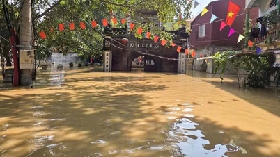
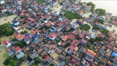
Flooded areas range from 0.3 to 2.5 m, concentrated on National Highway 17, National Highway 37 and provincial roads: 242, 292, 293, 294, 295, 298, 398. Notably, 29 of these areas are deeply flooded, making it impossible for vehicles to pass.
 |
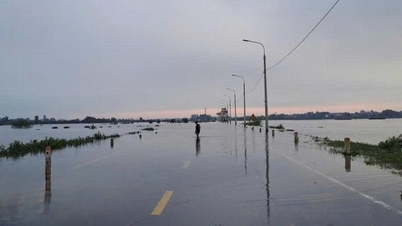
Authorities put up warning signs about deep water levels on Provincial Road 398B passing through Tu Lan ward. |
Specifically, on National Highway 17, water flooded at the following locations: Km 71+300, Km 73+500, Km 74+300, Km 74+690, Km 72+850, Km 73+650 through the communes of Xuan Luong, Tam Tien, Yen The; Provincial Road 242 flooded at Km 0+250 through Yen The commune.
Provincial Road 294B is flooded at Km3+400, Km3+220-Km3+750 through Ngoc Thien commune; Provincial Road 294 is flooded at Km0+200, Km2+400 through Quang Trung and Yen The communes; Provincial Road 288 is flooded at Km 14+700 through Hoang Van commune; Provincial Road 292 is flooded at Km7+200 - Km8; Km8+100, Km8+400, Km9+200, Km10+00, Km13+200, Km14+00 through Yen The commune.
Provincial Road 295 is flooded at Km 32+800, Km 39+500, Km40+00, Km44+100 through Tan Yen commune, Quang Trung commune; Provincial Road 296 is flooded at Km8+750 through Hop Thinh commune; Provincial Road 298 is flooded at Km4+900, Km5+630, Km12+400 through Tan Yen commune; Provincial Road 398B is flooded at the following locations: Km 20+400, Km 27+500, Km 36+700 through Tan Yen, My Thai, and Tien Luc communes.
According to the Department of Construction, up to this point, in the province, there are 2 deep flooded points on the roads where the water has receded, and people and vehicles have resumed traffic. These are at Km93+400 on National Highway 37 through Yen The commune; Km15+080 on Provincial Road 288 through Tan Yen commune. In addition, there are 3 points on Provincial Road 288 and National Highway 37 where the water is receding.
 |
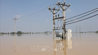
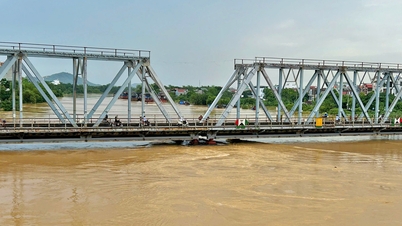
Authorities on duty at Provincial Road 298 where the water level is dangerously deep. |
In addition to flooding, Provincial Road 248, National Highway 31, National Highway 37, and National Highway 279 suffered landslides that caused rocks and soil to spill onto the roadway and subsidence of the negative slope, damaging the road surface structure.
Mr. Nguyen Viet Hung, Director of the Department of Construction, said that for locations with deep water and traffic disruption, the Department has coordinated with relevant agencies to arrange forces to guard, direct traffic, and ensure traffic safety on the route. For locations with landslides that have filled the longitudinal ditches and spilled onto the road, the Department requested the Bac Giang Road Joint Stock Company to continue mobilizing vehicles and equipment to clear the spilled soil onto the road, helping people and vehicles to travel smoothly.
For roads with damaged roadbeds, landslides, and damaged auxiliary works, Bac Giang Road Joint Stock Company has set up barriers and posted warning signs to ensure traffic safety.
Source: https://baobacninhtv.vn/bac-ninh-29-vi-tri-duong-giao-thong-phuong-tien-khong-the-luu-thong-postid428585.bbg
![[Photo] Opening of the World Cultural Festival in Hanoi](https://vphoto.vietnam.vn/thumb/1200x675/vietnam/resource/IMAGE/2025/10/10/1760113426728_ndo_br_lehoi-khaimac-jpg.webp)


![[Photo] Ho Chi Minh City is brilliant with flags and flowers on the eve of the 1st Party Congress, term 2025-2030](https://vphoto.vietnam.vn/thumb/1200x675/vietnam/resource/IMAGE/2025/10/10/1760102923219_ndo_br_thiet-ke-chua-co-ten-43-png.webp)

![[Photo] General Secretary attends the parade to celebrate the 80th anniversary of the founding of the Korean Workers' Party](https://vphoto.vietnam.vn/thumb/1200x675/vietnam/resource/IMAGE/2025/10/11/1760150039564_vna-potal-tong-bi-thu-du-le-duyet-binh-ky-niem-80-nam-thanh-lap-dang-lao-dong-trieu-tien-8331994-jpg.webp)


Comment (0)