
In this context, urban areas are developed on a foundation of green spaces, unique identity, and well-being, creating momentum, increasing attractiveness and competitiveness, adapting to integration trends, capable of responding to climate change, and contributing to improving the quality of life for residents.
Formation of a new urban area on the right bank of the Red River.

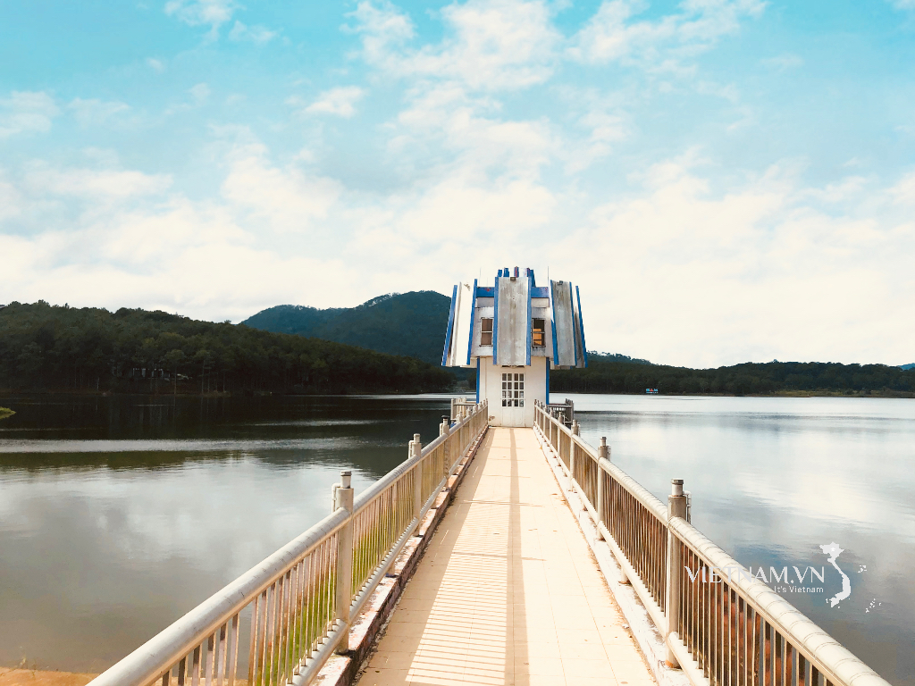
Immediately after leaving the Van Phu interchange on the Noi Bai - Lao Cai expressway and traveling on the connecting road to Yen Bai ward – the current provincial capital – we were amazed by a large-scale urban development project gradually taking shape. The project, named Yen Bai Riverside Urban Area, is being built on a total area of 23.85 hectares, located on Bach Lam Street, Au Lau ward. With a total investment of nearly 1,000 billion VND, the Yen Bai Riverside Urban Area received a construction permit from the People's Committee of Yen Bai City (formerly) in March 2024 and is expected to be completed this year. This is one of the projects demonstrating the urban shift from the left bank to the right bank of the Red River in the southern wards of the province.

The Red River flows through the former Yen Bai province, extending from the Lang Thip area (formerly Van Yen district) bordering Bao Yen district of the former Lao Cai province, through Van Yen and Tran Yen districts, and Yen Bai city. Due to its unique characteristics of varying elevations, frequent large floods, high flow velocity, and numerous landslide risks, urban development along the river is very difficult. However, over several decades, efforts to regulate the river have led to the formation of stable residential areas and the development of urban centers. Besides the largest urban center, the former Yen Bai city, further north, one can find towns such as Co Phuc, Bao Dap, Mau A, An Thinh, etc. (old place names).
To enhance urban connectivity along the Red River, Yen Bai province previously invested in constructing north-south and south-north-west roads, connecting urban areas within the province and with urban areas in the region. This was done to take advantage of the infrastructure connecting from national transportation axes that have been and are being invested in, such as the Noi Bai - Lao Cai expressway and the Lao Cai - Hanoi - Hai Phong railway.
This policy has been shaped by the former Yen Bai city over the years through key projects and constructions. Most recently, at the end of 2023, the Gioi Phien bridge, with a total investment of 650 billion VND, spanning the Red River, was officially inaugurated. Along with existing bridges including the Yen Bai bridge, Van Phu bridge, Tuan Quan bridge, and Bach Lam bridge, this is also the fifth bridge crossing the Red River in the former Yen Bai city area, contributing to connecting the two banks, linking the urban space being planned on the right bank of the Red River, and creating a highlight for the new central urban area of Lao Cai province.

According to the provincial Department of Construction, the new planning project to expand the former Yen Bai city area adopts a new approach, creating development space on the right bank of the Red River. Furthermore, building urban areas on both sides of the river requires bridges. Therefore, as the crow flies, the old Yen Bai city area, which is only a little over 7km away, has five bridges.
Spatial orientation on both banks of the Red River
The city of Yen Bai, formerly a riverside urban residential area, saw its administrative center of the former Yen Bai province (old) relocated to a hilly area about 40 years ago, forming a new urban center. Today, with the construction of highways and numerous bridges across the Red River, urbanization is expected to continue in the Red River riverside area.

To mitigate the risks of flooding, the former Yen Bai province developed a rational urban development plan for cities on both banks of the Red River, constructing urban areas linked to the creation of green spaces and public areas along both banks. The advantages of this plan include the creation of public green spaces along the Red River; strengthening the connection between existing and new urban areas on both sides of the Red River; developing riverside transportation infrastructure; creating a more attractive urban landscape along the Red River; improving the quality of life; and rationally exploiting and utilizing land along the Red River.

The urban spatial development orientation of Yen Bai (formerly) – now the southern part of Lao Cai province – comprises six functional zones. The central urban zone is the development center of the planning area, encompassing existing urban areas and newly developed urban areas centered around the Red River, creating a dynamic development hub. The industrial and service zone at the Hanoi-Lao Cai expressway interchange consists of two closely linked industrial and service areas connected to the IC12 and IC13 expressway interchanges and the main urban arteries. Located adjacent to the central urban zone, this zone promotes the development of industry, logistics services, trade, and tourism.
The industrial zone is the southeastern industrial zone of the central urban area, developed on the basis of continued investment in the construction of the industrial zone south of the former Yen Bai city. The Thac Ba Lake tourism and service urban zone is a zone developing diverse types of ecotourism that leverage the natural beauty of Thac Ba Lake; expanding the urban area in Yen Binh commune to become a commercial, service, and logistics center for the Thac Ba Lake tourist area. The Van Hoi Lake ecotourism zone is a zone developing tourism and high-tech agriculture and forestry in Van Hoi Lake and the surrounding area. The agricultural and forestry - rural zone comprises areas of agricultural and forestry production and rural settlements located around the urban and industrial zones.
Three main spatial axes form the framework for urban development: the cultural-tourism axis: the axis from Thac Ba Lake to Van Hoi Lake, passing through the central urban area, connecting tourist areas, new urban areas, commercial and service centers, and industrial centers with the IC12 interchange; the historical urban development axis: the urban axis connecting the existing urban area with new future development centers and with the IC12 and IC13 interchanges; and the Red River axis - the dynamic axis: the framework for the development of new urban areas along the Red River, which will become symbols of the strong economic development and urbanization of the central wards in the southern part of Lao Cai province in the future.
Two main transportation axes have been identified: inter-regional transportation axes (expressways and national highways connecting the planned area with economic regions both domestically and internationally) and urban transportation axes (main urban transportation axes in the direction of ring roads and radial routes connecting key urban centers and industrial hubs).
Lesson 3: The Ecological Green Belt in Viet Tri
Source: https://baolaocai.vn/bai-2-xay-dung-do-thi-ben-song-post399207.html
![[Photo] General Secretary To Lam receives the Chinese Ministers of Foreign Affairs, National Defense, and Public Security attending the Conference on the “3+3” Strategic Dialogue Mechanism](https://vphoto.vietnam.vn/thumb/1200x675/vietnam/resource/IMAGE/2026/03/16/1773659640884_a1-bnd-0963-2144-jpg.webp)
![[Photo] Prime Minister Pham Minh Chinh receives the Ministers of Foreign Affairs, Defense, and Public Security of China.](https://vphoto.vietnam.vn/thumb/1200x675/vietnam/resource/IMAGE/2026/03/16/1773659638054_ndo_br_dsc-4386-6157-jpg.webp)

![[Photo] Prime Minister Pham Minh Chinh holds a phone call with Angolan President João Manuel Gonçalves Lourenço](https://vphoto.vietnam.vn/thumb/1200x675/vietnam/resource/IMAGE/2026/03/16/1773674632171_ndo_br_dsc-4772-jpg.webp)
![[Photo] Prime Minister Pham Minh Chinh presides over meetings of the Government Standing Committee to discuss several important issues.](https://vphoto.vietnam.vn/thumb/1200x675/vietnam/resource/IMAGE/2026/03/16/1773674631996_ndo_br_img-5789-jpg.webp)
![[Photo] Secretary of the National Assembly Party Committee, Chairman of the National Assembly presides over the fourth meeting of the National Assembly Party Committee Executive Board.](https://vphoto.vietnam.vn/thumb/1200x675/vietnam/resource/IMAGE/2026/03/16/1773656046264_ndo_br_bnd-0533-jpg.webp)


Comment (0)