
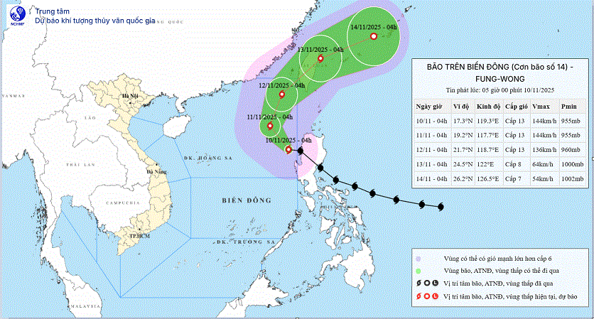
Early this morning (November 10), typhoon Fung-Wong entered the eastern sea area of the North East Sea, becoming the 14th typhoon in 2025. When entering the East Sea, the typhoon lost 2 levels of wind strength.
According to the National Center for Hydro-Meteorological Forecasting, at 4:00 a.m., the eye of the storm was at about 17.3 degrees North latitude; 119.3 degrees East longitude, in the eastern sea area of the North East Sea.
The strongest wind near the storm center is level 13 (134-149km/h), gusting to level 16. Moving in the West Northwest direction, speed about 25km/h.
Forecast, by 4am on November 11, storm No. 14 is in the eastern sea of the North East Sea with wind speed of level 13, gusting to level 16. The storm is moving northwest at a speed of 10-15 km/h. The affected area is the eastern sea of the North East Sea, with a disaster risk level of level 3.
At 4:00 a.m. on November 12, the storm was in the northeastern sea of the North East Sea with winds of level 13, gusts of level 16. The storm was moving in the North Northeast direction, at a speed of 10-15 km/h. The affected area was the eastern sea of the North East Sea, with a disaster risk level of level 3.
At 4:00 a.m. on January 13, the storm was in the northeastern coastal area of Taiwan (China) and gradually weakened. The storm moved northeast at a speed of 15-20 km/h. The affected area was the northeastern sea area of the North East Sea, with a disaster risk level of level 3.
From the next 72 to 96 hours, the storm will move in the East Northeast direction, traveling 20-25km per hour and continue to weaken.
Due to the impact of the storm, at sea, the eastern sea area of the North East Sea has strong winds of level 8-10; the area near the eye of the storm has strong winds of level 11-13, gusts of level 16, waves 5-8m high, the area near the eye of the storm is 8-10m. The sea is very rough.
In the East of the Central East Sea, there are strong winds of level 6-7, gusting to level 8-9. Waves are 6-8m high. The sea is rough.
In addition, on the day and night of November 10, the eastern sea area of the North East Sea will have storms and rain, and the eastern sea area of the Central East Sea will have showers and thunderstorms. During thunderstorms, there is a possibility of tornadoes and strong gusts of wind.
All vessels operating in the above-mentioned danger zones are at risk of being affected by storms, whirlwinds, strong winds, and large waves. The risk level for natural disasters at sea is level 2, while the eastern sea area of the North East Sea is level 3.
Specific weather in each region
- The Northwest has scattered showers and thunderstorms. Thunderstorms may cause tornadoes, lightning, and strong gusts of wind. The lowest temperature is about 19-22 degrees Celsius, the highest is from 25-28 degrees Celsius.
- In the early morning, the Northeast region has scattered showers and thunderstorms; in the Northeast and the plains, the clouds will decrease and it will be sunny in the afternoon. Northeast to North wind level 2-3. The lowest temperature is from 21-24 degrees Celsius, the highest is from 26-29 degrees Celsius, some places below 26 degrees Celsius.
- From Thanh Hoa to Hue, the weather is clearly differentiated: in the North it is cloudy with scattered rain; in the South it is cloudy with scattered showers and thunderstorms. The North to Northwest wind is level 2-3. The lowest temperature is from 21-24 degrees Celsius, the highest is from 26-29 degrees Celsius.
- South Central Coast : Sunny during the day; showers and thunderstorms in some places in the afternoon and evening. Light wind, watch out for tornadoes, lightning and strong gusts during thunderstorms. Lowest temperature from 22-25 degrees Celsius, highest from 29-32 degrees Celsius.
- The Central Highlands will be sunny during the day, with showers and thunderstorms in some places in the late afternoon and at night, with the possibility of tornadoes, lightning and strong gusts of wind during thunderstorms. The lowest temperature will be from 20-23 degrees Celsius, the highest from 28-31 degrees Celsius.
- In the South, it is sunny during the day; in the late afternoon there will be scattered showers and thunderstorms in some places, at night there will be showers and thunderstorms in some places, in thunderstorms, beware of tornadoes, lightning and strong gusts of wind. The lowest temperature is from 24-27 degrees Celsius, the highest is from 30-33 degrees Celsius.
- Hanoi capital has rain in some places. In the afternoon and evening, the clouds will decrease, the sky will be sunny, the Northeast to North wind will be level 2-3. The lowest temperature will be from 21-23 degrees Celsius, the highest from 26-28 degrees Celsius.
- Ho Chi Minh City has sunny days, with showers and thunderstorms in some places in the late afternoon and at night. The lowest temperature ranges from 24-26 degrees Celsius, the highest from 30-33 degrees Celsius./.
Source: https://baolaocai.vn/bao-fung-wong-giam-cap-di-vao-bien-dong-va-tro-thanh-con-bao-so-14-post886443.html

![[Photo] Chu Noodles - the essence of rice and sunshine](https://vphoto.vietnam.vn/thumb/1200x675/vietnam/resource/IMAGE/2025/11/11/1762846220477_ndo_tl_7-jpg.webp)
![[Photo] Prime Minister Pham Minh Chinh chairs a meeting on housing policy and the real estate market.](https://vphoto.vietnam.vn/thumb/1200x675/vietnam/resource/IMAGE/2025/11/11/1762838719858_dsc-2107-jpg.webp)


![Building 'fortresses' against natural disasters: [Part 5] Outstanding technologies](https://vphoto.vietnam.vn/thumb/402x226/vietnam/resource/IMAGE/2025/11/11/1762824019713_0037-0021-images1955226_f-nongnghiep-000009.jpeg)


![Dong Nai OCOP transformation: [Article 4] Reaching national standard products](https://vphoto.vietnam.vn/thumb/402x226/vietnam/resource/IMAGE/2025/11/11/1762825820379_4702-cac-san-pham-trai-cay-chung-nhan-ocop-nongnghiep-174649.jpeg)


![Dong Nai OCOP transition: [Article 3] Linking tourism with OCOP product consumption](https://vphoto.vietnam.vn/thumb/402x226/vietnam/resource/IMAGE/2025/11/10/1762739199309_1324-2740-7_n-162543_981.jpeg)


Comment (0)