
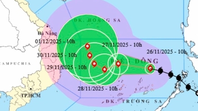
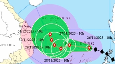
At 4:00 a.m. on November 26, the center of the storm was at about 12.2 degrees North latitude; 119.1 degrees East longitude, about 540 km east of Song Tu Tay island. The strongest wind near the center of the storm was level 8 (62-74 km/h), gusting to level 10. Moving northwest at a speed of 20-25 km/h.
Forecast of tropical depression/storm development
At 4:00 a.m. on November 27, the center of the storm was at 13.0°N – 115.2°E, about 200 km northeast of Song Tu Tay Island. The storm moved west-northwest at a speed of 15–20 km/h. The storm is forecast to intensify, reaching level 10, gusting to level 13.
The danger zone is defined from 10.0°N to 14.5°N; east of longitude 113.5°E.

Storm No. 15 is about 540km from Song Tu Tay Island.
At 4:00 a.m. on November 28, the storm changed direction to West Southwest at a speed of 5-10 km/h, remaining in the Central East Sea area, about 150 km northwest of Song Tu Tay Island. The storm intensity increased to level 11, gusting to level 14. The danger zone expanded from 10.5°N to 14.5°N and from 112.0°E to 117.0°E.
At 4:00 a.m. on November 29, the storm slowed down to the West, at a speed of about 5 km/h, moving closer to the West of the Central East Sea. The center of the storm was at about 12.3°N - 112.4°E, about 250 km west-northwest of Song Tu Tay Island. The storm maintained a level 11 intensity, gusting to level 14. The danger zone is from 10.5°N to 14.5°N; 110.5°E to 115.5°E.
Storm warning (next 48 to 72 hours)
From the next 72 to 120 hours, the storm will move to the Northwest, at a speed of about 5km/h and gradually weaken.
Forecast of impact of tropical depression/storm: Strong winds, big waves
At sea:
The Central East Sea area (including the sea area north of Truong Sa special zone) has strong winds of level 6-7; the area near the storm's eye has strong winds of level 8-10, gusting to level 13; waves 4.0-6.0m high, the area near the storm's eye 6.0-8.0m; very rough seas.
Warning: During November 27-28, the Central East Sea area (including the sea area north of Truong Sa special zone) is likely to be affected by strong winds of level 11, gusts of level 14, waves 7.0-9.0m high, and rough seas.
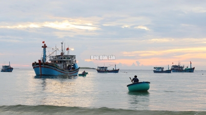
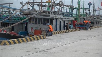
Vessels operating in the above mentioned dangerous areas are susceptible to the impact of storms, whirlwinds, strong winds and large waves.
Source: https://baolaocai.vn/bao-so-15-cach-dao-song-tu-tay-khoang-540km-giat-cap-14-post887595.html

![[Photo] VinUni students' emotions are sublimated with "Homeland in the Heart: The Concert Film"](/_next/image?url=https%3A%2F%2Fvphoto.vietnam.vn%2Fthumb%2F1200x675%2Fvietnam%2Fresource%2FIMAGE%2F2025%2F11%2F26%2F1764174931822_10-3878-jpg.webp&w=3840&q=75)


![[Photo] Close-up of heavy damage at the school located on the banks of the Ban Thach River](/_next/image?url=https%3A%2F%2Fvphoto.vietnam.vn%2Fthumb%2F1200x675%2Fvietnam%2Fresource%2FIMAGE%2F2025%2F11%2F26%2F1764152130492_ndo_bl_img-8188-8805-jpg.webp&w=3840&q=75)


![[Photo] Opening of the 28th Session of the Hanoi People's Council](https://vphoto.vietnam.vn/thumb/402x226/vietnam/resource/IMAGE/2025/11/26/1764155991133_image.jpeg)


Comment (0)