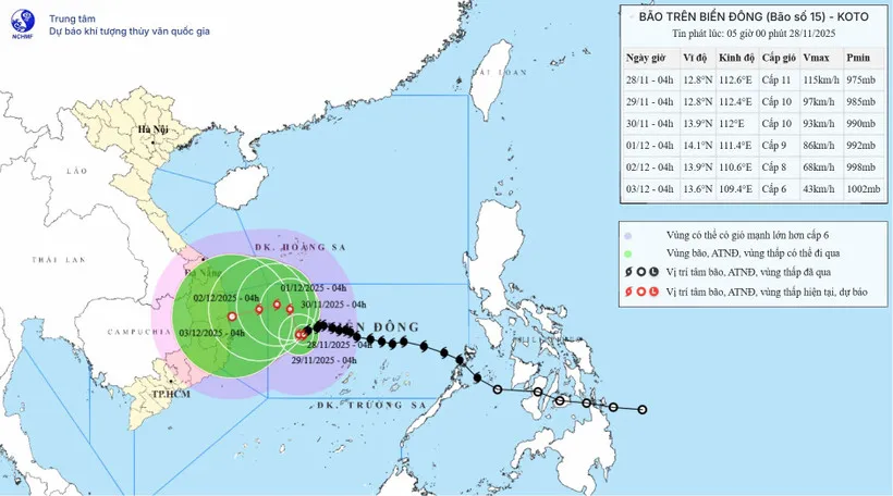
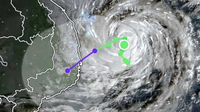
From 10pm on November 27 to 4am on November 28, storm No. 15 continued to move slowly, reduced its intensity by 1 level and changed direction, currently moving in the West Southwest direction (at 10pm on November 27 it was West direction). Strong winds level 11, gusts level 14.
According to the forecast of the National Center for Hydro-Meteorological Forecasting, at 4:00 a.m. on November 28, the center of the storm was at about 12.8 degrees North latitude; 112.6 degrees East longitude, about 240km northwest of Song Tu Tay island.
The strongest wind near the storm center is level 11 (103-117 km/h), gusting to level 14. The storm moves in a West Southwest direction at a speed of 5 km/h.
Forecast until 4:00 a.m. on November 29, the storm is in the western sea area of the central East Sea, about 260km northwest of Song Tu Tay island.
The storm is moving west at a speed of about 3 km/h, gradually weakening. The strongest wind is level 10, gusting to level 14.
The affected area is the central East Sea (including the sea area north of Truong Sa special zone), level 3 natural disaster risk.
At 4am on November 30, the storm was in the northwest sea area of the central East Sea, about 300km east of the eastern coast of Gia Lai province. The storm moved northwest at a speed of about 5km/h, gradually weakening. The strongest wind was level 9-10, gusting to level 13.
The affected area is the western sea area of the central East Sea (including the northwest sea area of Truong Sa special zone), the offshore sea area of provinces from Gia Lai to Khanh Hoa , level 3 natural disaster risk.
At 4:00 a.m. on December 1, the storm was in the northwest sea area of the central East Sea, about 210km east of the eastern coast of Gia Lai province.
The storm is moving northwest at a speed of about 3-5 km/hour, gradually weakening. The strongest wind is level 9, gusting to level 12.
The affected area is the western sea area of the central East Sea, the sea off the coast of provinces from Quang Ngai to Dak Lak , level 3 natural disaster risk.
From the next 72-120 hours, the storm will move slowly to the West, then likely change direction to the West Southwest at a speed of about 5 km/hour and continue to weaken.
Due to the impact of the storm, the central East Sea area (including the sea area north of Truong Sa special zone) has strong winds of level 7-9; the area near the eye of the storm has strong winds of level 10-11, gusts of level 14; waves 4-6m high, the area near the eye of the storm has 7-9m; the sea is very rough. The sea area offshore from Gia Lai to Khanh Hoa has strong winds of level 6-7, then increasing to level 8, gusts of level 9-10, waves 5-7m high, and very rough sea.
Vessels operating in the above mentioned danger zones are likely to be affected by storms, whirlwinds, strong winds and large waves. Strong winds and high waves occur in many sea areas.
At sea, currently in the North East Sea (including Hoang Sa special zone), there is Northeast wind level 7, gusting to level 9; Bach Long Vi and Ly Son stations have Northeast wind level 6, sometimes level 7, gusting to level 8-9; Huyen Tran station has Northeast wind level 6-7, gusting to level 8-9.
Forecast for the next 24 hours, North East Sea (including Hoang Sa special zone), day Northeast wind level 7-8, gust level 9-10, night level 6-7, gust level 8-9, rough sea, waves 5-7m high.
Southwest of the East Sea (including the West of Truong Sa special zone), wind level 7 during the day, gusting to level 8-9; decreasing at night. Rough seas, waves 5-7m.
The sea area from South Quang Tri to Hue city has Northeast to North wind level 6, sometimes level 7, gusting to level 8-9; waves 4-6m, rough sea.
On the morning of November 28, the Gulf of Tonkin has northeast wind level 5, sometimes level 6, gusting to level 7-8; waves 2-4m high, rough sea.
The South and North East Sea (including Hoang Sa special zone) and the South East Sea (including the South of Truong Sa special zone) will have scattered showers and thunderstorms, with the possibility of tornadoes and strong gusts of wind.
Warning, day and night of November 29, North East Sea (including Hoang Sa special zone) Northeast wind level 6, sometimes level 7 during the day, gusting to level 8-9, waves 5-7m high, rough seas.
Sea area from South Quang Tri - Hue: Northeast wind level 5, sometimes level 6, gusting to level 7-8, waves 3-5m high, rough sea. Disaster risk level: level 2. Weather in the areas from November 28 to December 7.
On November 28, the North and North Central regions will have no rain at night, some places will have fog in the early morning, and sunny days. The night and morning will be cold, some places in the mountainous areas of the North will be very cold; especially in the high mountains, beware of the possibility of frost.
Other areas have scattered showers and thunderstorms, with the possibility of tornadoes, lightning and strong gusts of wind.
From the night of November 29 to December 1, the North and North Central regions will have no rain at night and sunny days. The nights and mornings will be cold, with some places in the mountainous areas of the North experiencing severe cold.
From January 2 to 6, there will be rain in some places; from the night of December 3 to 4, there will be scattered rain in the Northeast and North Central regions. It will be cold in the morning and at night.
Areas from Quang Tri to Hue city and the South Central coastal provinces: scattered showers and thunderstorms; from the night of November 30 to December 3, there is a possibility of moderate to heavy rain.
From December 4 to 6, there will be rain, showers, and heavy rain in some places.
The Central Highlands has scattered showers and thunderstorms; from about December 1 to 3, there will be rain, locally heavy rain and thunderstorms.
Other areas have scattered showers and thunderstorms, with the possibility of tornadoes, lightning, hail and strong gusts of wind.
Source: https://www.sggp.org.vn/bao-so-15-giam-cuong-do-doi-huong-va-tiep-tuc-di-chuyen-cham-post825865.html































Comment (0)