
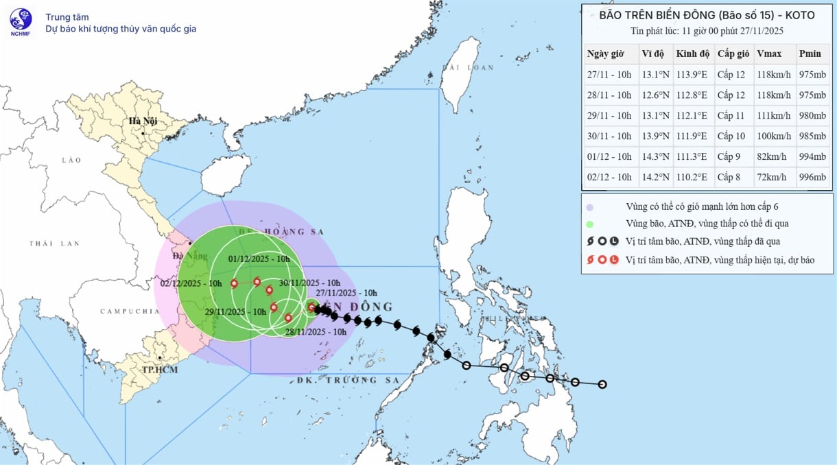
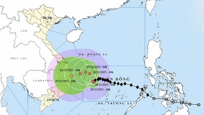
According to the forecast of the National Center for Hydro-Meteorological Forecasting, at 10:00 a.m. on November 27, the center of the storm was at about 13.1 degrees North latitude; 113.9 degrees East longitude, about 190 km north of Song Tu Tay island. The strongest wind near the center of the storm was level 12 (118-133 km/h), gusting to level 15. Moving in the West Northwest direction, speed 5-10 km/h.
Forecast until 10:00 on November 28, the storm is in the western sea area of the Central East Sea, about 210 km northwest of Song Tu Tay Island. The storm is moving in the West Southwest direction at a speed of about 5-10 km/h. The strongest wind is level 12, gusting to level 15. The affected area is the Central East Sea area (including the northern sea area of Truong Sa special zone), with a natural disaster risk level of level 3.
As of 10:00 a.m. on November 29, the storm was in the western sea area of the Central East Sea. The storm moved northwest at a speed of about 3-5 km/h. The strongest wind was level 11, gusting to level 14. The affected area was the western sea area of the Central East Sea (including the northwest sea area of Truong Sa special zone), with a level 3 natural disaster risk.
As of 10:00 a.m. on November 30, the storm was in the northwest sea area of the Central East Sea. The storm moved northwest at a speed of about 3-5 km/h. The strongest wind was level 10, gusting to level 13. The affected area was the western sea area of the Central East Sea, with a natural disaster risk level of level 3.
From the next 72 to 120 hours, the storm will move slowly to the Northwest, then likely change direction to the West, speed 3-5 km/h and intensity will continue to weaken.
Due to the impact of the storm, the Central East Sea area (including the sea area north of Truong Sa special zone) has strong winds of level 7-9; the area near the storm's eye has strong winds of level 10-12, gusting to level 15; waves 4-6m high, the area near the storm's eye 7-9m; the sea is very rough.
Vessels operating in the above mentioned dangerous areas are susceptible to the impact of storms, whirlwinds, strong winds and large waves.
Source: https://baotintuc.vn/van-de-quan-tam/bao-so-15-giu-nguyen-cuong-do-di-chuyen-cham-huong-ve-giua-bien-dong-20251127114806507.htm
![[Photo] Prime Minister Pham Minh Chinh chairs the 15th meeting of the Central Emulation and Reward Council](/_next/image?url=https%3A%2F%2Fvphoto.vietnam.vn%2Fthumb%2F1200x675%2Fvietnam%2Fresource%2FIMAGE%2F2025%2F11%2F27%2F1764245150205_dsc-1922-jpg.webp&w=3840&q=75)


![[Photo] President Luong Cuong attends the 50th Anniversary of Laos National Day](/_next/image?url=https%3A%2F%2Fvphoto.vietnam.vn%2Fthumb%2F1200x675%2Fvietnam%2Fresource%2FIMAGE%2F2025%2F11%2F27%2F1764225638930_ndo_br_1-jpg.webp&w=3840&q=75)


Comment (0)