
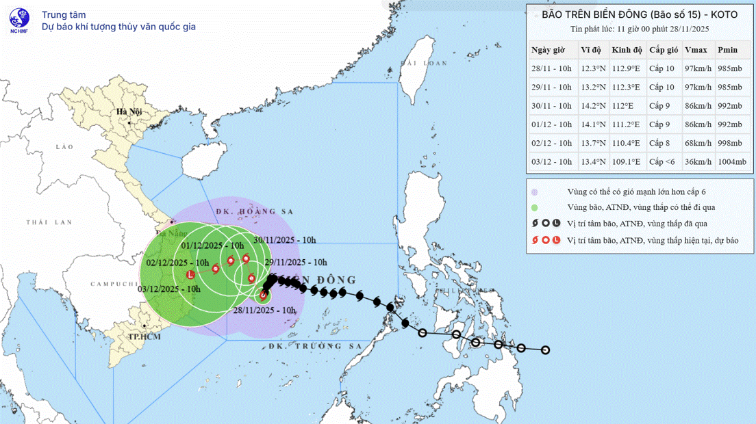
The National Center for Hydro-Meteorological Forecasting said that at 4:00 a.m. this morning, November 27, the center of storm No. 15 (storm Koto) was at about 13.0 degrees north latitude and 114.5 degrees east longitude, about 190 km north of Song Tu Tay Island (Truong Sa special zone). Near the center of the storm, the strongest wind was at level 12, equivalent to wind speed from 118 - 133 km/h, gusting to level 15. The storm is moving west-northwest, at a speed of about 15 km/h.

Storm No. 15 has strengthened to level 12, gusting to level 15 (PHOTO: VNDMS)
Forecast until 4:00 tomorrow, November 28, the center of the storm is located at 12.5 degrees north latitude and 113.1 degrees east longitude, in the sea west of the central East Sea, about 190 km east of Song Tu Tay island. At this time, storm No. 15 changed direction, moving west-southwest, speed reduced to 5 - 10 km/h. Area near the center of the storm, strong wind intensity level 12, gust level 15.
At 4:00 a.m. on November 29, the center of the storm was located at about 12.9 degrees north latitude and 112.3 degrees east longitude, in the sea west of the central East Sea, the intensity weakened to level 11, gusting to level 14. At this time, the storm moved in a west-northwest direction, then continued to change to the northwest, at a speed of about 5 km/hour.
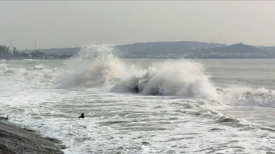
The National Center for Hydro-Meteorological Forecasting warns that due to the impact of storm No. 15, the central East Sea area (including the sea area north of Truong Sa special zone) will have strong winds of level 7 - 9; the area near the storm's eye will have strong winds of level 10 - 12, gusting to level 15. Waves will be 4 - 6 m high, the area near the storm's eye will have waves of 7 - 9 m high, and the sea will be very rough.
Explaining why storm No. 15 continues to intensify as it enters the East Sea, Mr. Hoang Phuc Lam, Deputy Director of the National Center for Hydro-Meteorological Forecasting, said that the storm is operating in warm waters. The sea temperature is around 27 - 28 degrees Celsius, which is a factor that causes the storm to intensify very quickly and maintain a stable intensity.
Today, the cold air will begin to strengthen and move down. Tomorrow, November 28, the cold air will directly interact and penetrate the storm circulation. In addition, the storm will move to longitude 112 - 113, this is a colder sea area, so the storm will begin to weaken but its subsequent developments will be relatively complicated.
"We cannot rule out the possibility that storm No. 15 will weaken and dissipate at sea, without directly affecting the mainland," Mr. Lam said./.
According to Thanh Nien Newspaper
Source: https://thanhnien.vn/bao-so-15-manh-cap-12-giat-cap-15-185251127064014694.htm
Source: https://baolongan.vn/bao-so-15-manh-cap-12-giat-cap-15-a207294.html


![[Photo] President Luong Cuong attends the 50th Anniversary of Laos National Day](/_next/image?url=https%3A%2F%2Fvphoto.vietnam.vn%2Fthumb%2F1200x675%2Fvietnam%2Fresource%2FIMAGE%2F2025%2F11%2F27%2F1764225638930_ndo_br_1-jpg.webp&w=3840&q=75)
![[Photo] Prime Minister Pham Minh Chinh chairs the 15th meeting of the Central Emulation and Reward Council](/_next/image?url=https%3A%2F%2Fvphoto.vietnam.vn%2Fthumb%2F1200x675%2Fvietnam%2Fresource%2FIMAGE%2F2025%2F11%2F27%2F1764245150205_dsc-1922-jpg.webp&w=3840&q=75)


Comment (0)