
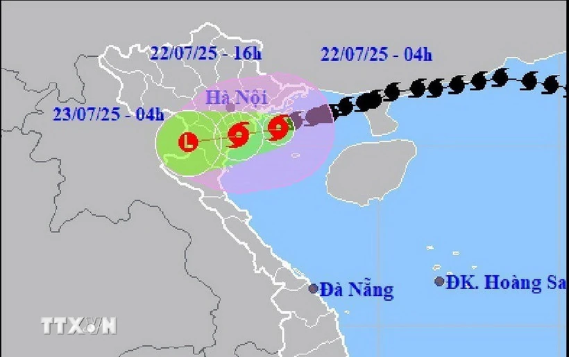
According to the National Center for Hydro-Meteorological Forecasting, at 7:00 a.m. on July 22, the storm center was at about 20.2°N; 106.7°E (coast of Hai Phong - Ninh Binh).
The strongest wind is level 9 (75-88km/h), gusting to level 12, the storm is moving in the West Southwest direction at a speed of about 15km/h.
Due to the influence of storm No. 3, in coastal special zones there were strong winds, specifically Bach Long Vi level 10, gust level 12; Co To level 8, gust level 11; Cat Ba level 6, gust level 8; Cua Ong level 9, gust level 12; Bai Chay level 8, gust level 9; Quang Ha level 8; Tien Yen level 7, gust level 9; Thai Binh level 7, gust level 8; Mong Cai level 6, gust level 9; Phu Lien level 6, gust level 8.
The Northern Delta and coastal areas, Thanh Hoa and Nghe An have moderate to very heavy rain, commonly 70-150mm, in some places >200mm.
Forecast, 7pm on July 22, storm on land from Hai Phong to Thanh Hoa, level 6, gust level 8. At 7:00 a.m. on July 23, the storm in Upper Laos weakened into a low pressure area.
In the Northern Gulf of Tonkin (Bach Long Vi, Co To, Van Don, Cat Hai, Hon Dau): wind level 6-7, near the storm center level 8-9, gust level 12; waves 2-4m high, near the storm center 3-5m; very rough seas
In the South of Bac Bo Gulf (Hon Ngu): wind level 6-7, near the storm center level 8, gust level 11; waves 2-4m high; rough seas.
Coastal areas of Hung Yen-Quang Ninh, water level rises 0.5-1.0m. Specifically, water level: Ba Lat 2.4-2.6m; Hon Dau 3.9-4.1m; Cua Ong 4.6-5.0m; Tra Co 3.6-4.0m
High risk of flooding along the coast and river mouths at noon on July 22.
The Hydrometeorological Agency forecasts extremely dangerous weather conditions at sea and along the coast: Unsafe for all vehicles and structures.
Boats, cages, aquaculture areas, and coastal structures are at high risk of capsizing and being destroyed by strong winds, storms, big waves, and rising waters.
Inland from Quang Ninh-Nghe An: wind level 6-7, near the storm center level 8-9, gust level 12. Inland (Hai Phong, Hung Yen, Bac Ninh, Hanoi, Ninh Binh, Thanh Hoa): wind level 6, gust level 7-8. Strong wind level 9 can cause broken trees, blown roofs, and damage to houses.
From July 22-23, Northern Delta, Thanh Hoa, Nghe An: heavy to very heavy rain, 100-200mm, locally >300mm.
Other areas in the North and Ha Tinh: moderate to heavy rain, commonly 50-100mm, locally >150mm.
Warning of heavy rain >150mm/3h, risk of flash floods, landslides, flooding in urban areas and low-lying areas.
The National Center for Hydro-Meteorological Forecasting reported that through monitoring satellite images, thunderstorm location data and weather radar, it was detected that convective clouds continued to develop and cause rain in the areas of Doai Phuong, Yen Xuan, Hoa Lac, Huong Son, Dai Xuyen, Phu Xuyen, Chuyen My, Ung Hoa, Ba Vi, and Yen Bai of Hanoi city.
Warning, from 5:20 a.m. to 8:30 a.m. on July 22, this cloud area will continue to cause rain in the above areas, then spread to other wards/communes of Hanoi city, during thunderstorms there is a possibility of tornadoes, lightning and strong gusts of wind. Warning level of natural disaster risk due to tornadoes, lightning, hail: Level 1.
Faced with the above weather conditions, Head of Weather Forecast Department, National Center for Hydro-Meteorological Forecasting Nguyen Van Huong warned that thunderstorms, tornadoes, lightning, and strong gusts of wind pose a potential risk to people's lives and property.
Tornadoes often occur with severe thunderstorms. When there is a thunderstorm warning, people should take shelter in safe places in solidly built structures.
Source: VNA
Source: https://baophutho.vn/bao-so-3-o-ven-bo-hai-phong-ninh-binh-suc-gio-manh-nhat-cap-9-giat-cap-12-236517.htm


![[Photo] National Assembly Chairman attends the seminar "Building and operating an international financial center and recommendations for Vietnam"](https://vphoto.vietnam.vn/thumb/1200x675/vietnam/resource/IMAGE/2025/7/28/76393436936e457db31ec84433289f72)


Comment (0)