
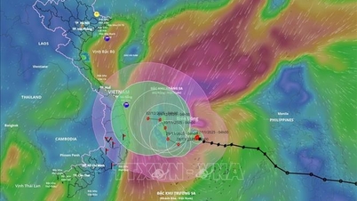
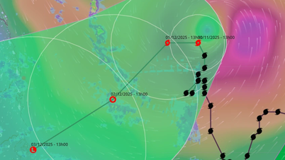
At 1:00 p.m. on August 25, the center of storm No. 5 Kajiki was located in the coastal waters of Ha Tinh - Nghe An. The strongest wind near the center of the storm was level 13 (134-149 km/h), gusting to level 16. In the next 3 hours, storm No. 5 will move in the West Northwest direction, at a speed of about 15 km/h.
Mr. Mai Van Khiem - Director of the National Center for Hydro-Meteorological Forecasting said that with the direction, intensity and speed of movement of storm No. 5, it is heading towards the sea area of Ha Tinh - Thanh Hoa. The storm is forecast to make landfall from 4-7pm today, August 25, the landfall area is South Thanh Hoa - Ha Tinh, with the focus on Nghe An province. The period of strong winds lasts from 1-7pm on the same day.
“We especially emphasize that the areas of Southern Thanh Hoa, Nghe An, and Northern Ha Tinh (localities bordering Nghe An) are at risk of strong winds of level 11-12, even above level 12, gusting to level 14-15, which is very dangerous,” said Mr. Khiem.
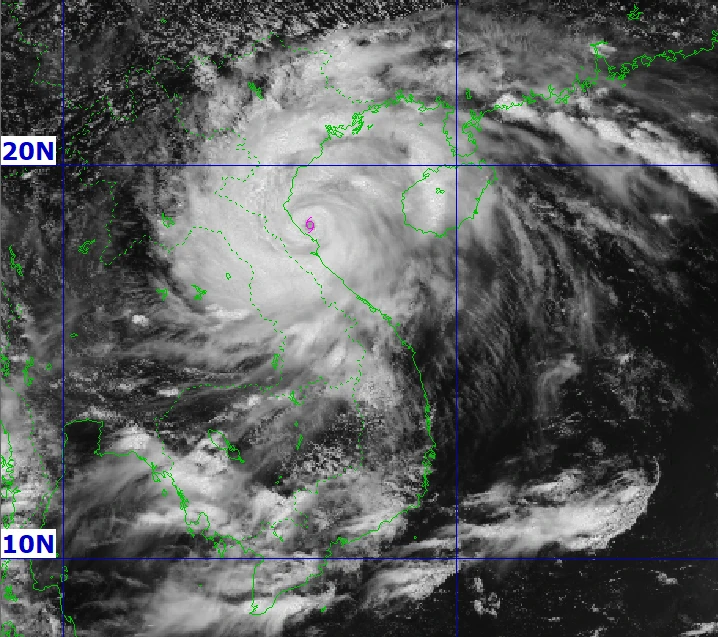
Forecast from 4-7pm today, August 25, storm No. 5 will make landfall in the South of Thanh Hoa - Ha Tinh. (Source: NCHMF)
This is not the strongest moment of storm No. 5 as the storm is still about 100km from the shore. The hydrometeorological stations along the coast in Nghe An and Ha Tinh have only observed winds of level 6-7, gusting to level 8-9. In particular, Hon Ngu island has observed winds of level 8, gusting to level 9.
Northern coastal areas such as Hai Phong and Quang Ninh have observed winds of level 5 and 6. In particular, Co To has winds of level 7, gusts of level 9, Bai Chay has winds of level 6, gusts of level 8.
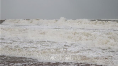
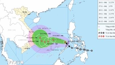
As of 10am this morning, the waves were very high. Specifically, in Nghi Xuan (Ha Tinh), very high waves were observed, ranging from 6.9 to 8.35m. Other areas in Nghe An and Thanh Hoa also observed relatively high waves such as Nghe An 5.25m.
It is forecasted that areas such as the South of Quang Tri, Ha Tinh, Nghe An, Thanh Hoa will continue to have waves of 5-7m high when this storm affects and enters our mainland. These waves are very dangerous for dike activities.
"We want to emphasize that in the North of Nghe An and Thanh Hoa, waves of 5-7m high, and near the storm center, can reach 8m, will greatly affect the dike system. The dike system in the Northern sea area, including Ninh Binh, Hung Yen (formerly Nam Dinh and Thai Binh), must also be extremely cautious," Mr. Khiem noted.
Commenting on the rain situation due to the impact of storm No. 5 Kajiki, Mr. Mai Van Khiem said that from yesterday until now, there has been a relatively large amount of rain in the North and North Central regions.
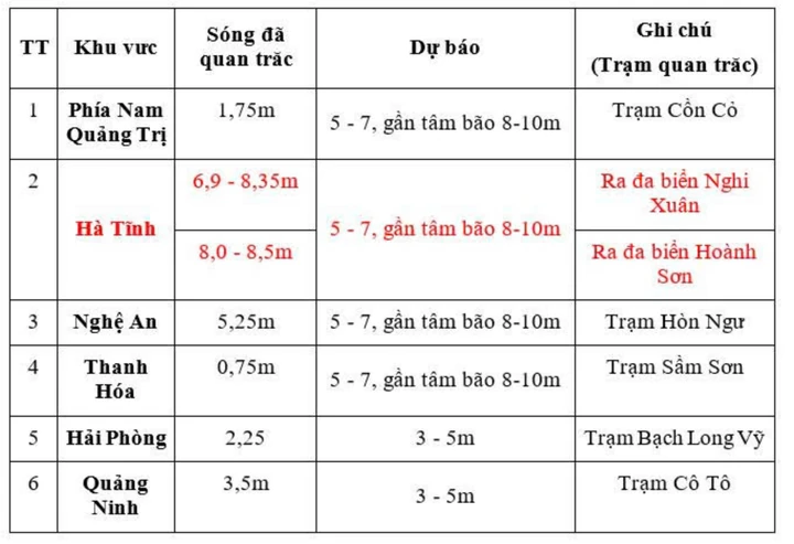
Information on ocean waves updated at 10am on August 25. (Source: NCHMF)
The meteorological agency recorded the accumulated rainfall from 7pm on August 24 to 10am on August 25, some places had very heavy rainfall of over 300mm. There were places like Cam Xuyen, where the total accumulated rainfall in 3 hours, from 7am to 10am on August 25 was 176.2mm, this is a very heavy rainfall.
Rain is forecast to continue, appearing between today and tomorrow under the direct impact of storm circulation No. 5 Kajiki.
Heavy rain has occurred and will continue today and tomorrow, with risks of flooding on rivers, especially in river basins in Nghe An, Ha Tinh, and Thanh Hoa. Risks of flash floods and landslides in mountainous areas in the West and North Central regions such as Nghe An, Thanh Hoa, Ha Tinh, and Quang Tri.
Currently, through analysis of satellite cloud images as well as meteorological radar observations in Vietnam, the cloud structure system of this storm has some initial signs, the storm may be weakening in intensity.
However, with storm intensity above level 12, level 13,14, when impacting the mainland, many structures if not solid will be greatly affected.
Source vnexpress.net
=>>>Storm No. 5 approaches land, dangerous level 16 wind gusts
Source: https://baophutho.vn/bao-so-5-giat-cap-13-khoang-16-19h-do-bo-dat-lien-trong-tam-o-tinh-nghe-an-238516.htm


![[Photo] Dan Mountain Ginseng, a precious gift from nature to Kinh Bac land](/_next/image?url=https%3A%2F%2Fvphoto.vietnam.vn%2Fthumb%2F1200x675%2Fvietnam%2Fresource%2FIMAGE%2F2025%2F11%2F30%2F1764493588163_ndo_br_anh-longform-jpg.webp&w=3840&q=75)


Comment (0)