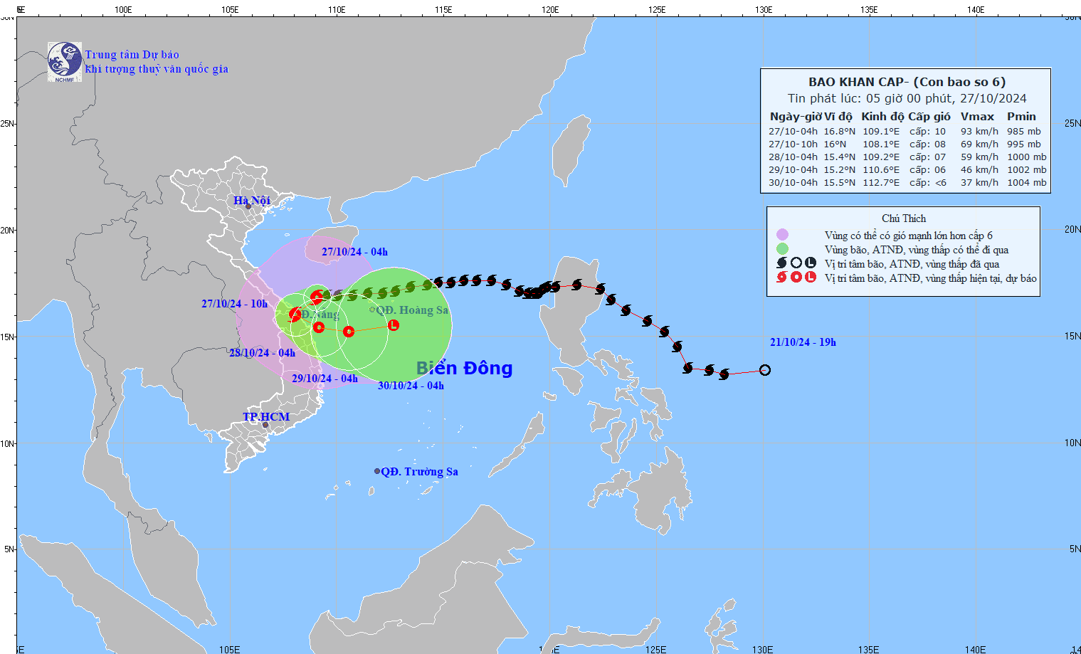
Storm No. 6 (Tra Mi storm) is about 110 km east-northeast of Da Nang , and is expected to make landfall in the provinces from Quang Tri to Quang Ngai at noon on October 27.
The National Center for Hydro-Meteorological Forecasting said that at 6:00 a.m. this morning, October 27, the center of storm No. 6 (storm Tra Mi) was at about 16.8 degrees north latitude; 108.9 degrees east longitude, about 110 km east-northeast of Da Nang. The storm is at level 9 - level 10 (75 - 102 km/h), gusting to level 12, moving west-southwest, traveling 15 km per hour.
When will storm No. 6 (Tra Mi) have the strongest impact on land?

Forecast map of storm No. 6's path
PHOTO: NCHMF
In the next 4-5 hours, storm No. 6 will make landfall in the provinces from Quang Tri to Quang Ngai and weaken into a tropical depression.
At 4:00 a.m. on October 28, the tropical depression was in the coastal waters of Central Central Vietnam, level 6 - level 7, gusting to level 9. The tropical depression existed in the coastal waters of Central Central Vietnam for about 1 day, then moved out to sea and weakened into a low pressure area.
Due to the influence of storm No. 6, the western sea area of the northern East Sea has strong winds of level 6 - level 7, sometimes level 8, gusting to level 10, waves 2 - 4 m high; rough seas.
The sea areas of the provinces from Quang Binh to Quang Ngai (including Con Co Island, Cu Lao Cham, Ly Son) have strong winds of level 6 - level 7, the area near the storm's center has winds of level 8 - level 10, gusts of level 12, waves 3 - 5 m high; very rough seas.
From the morning of October 27, coastal areas from Quang Binh to Quang Nam provinces are likely to experience storm surges of 0.4 - 0.6 m high. Ships and boats operating in the above-mentioned dangerous areas (especially in the Hoang Sa island district), coastal areas from Quang Binh to Quang Ngai are likely to be affected by storms, whirlwinds, strong winds, and large waves.
High risk of landslides of sea dikes and embankments along the coast of provinces from Quang Tri to Quang Nam due to the impact of big waves and storm surges.
Central region pouring rain due to storm number 6
Inland provinces from Quang Binh to Quang Ngai have winds gradually increasing to level 6 - level 7, gusting to level 8 - level 9; areas near the storm center have winds of level 8 - level 9, gusting to level 11.
Currently, the Central provinces are experiencing torrential rain. Thua Thien - Hue province recorded 268 mm of rain, Quang Tri 194 mm, Quang Binh 113 mm, and Da Nang 135 mm last night.
It is forecasted that from the morning of October 27-28, in the area from Quang Binh to Quang Ngai, there will be heavy to very heavy rain and thunderstorms with rainfall from 200-400 mm, some places over 600 mm; warning of the risk of localized heavy rain (over 100 mm/3 hours).
Ha Tinh, Binh Dinh and the Northern Central Highlands have moderate rain, heavy rain and thunderstorms, some places have very heavy rain with rainfall from 100 - 180 mm, some places over 250 mm.
Thanhnien.vn
Source: https://thanhnien.vn/bao-so-6-ap-sat-da-nang-mien-trung-mua-xoi-xa-185241027070822686.htm


![[Photo] Nearly 104,000 candidates in Hanoi complete procedures to take the 10th grade entrance exam](https://vphoto.vietnam.vn/thumb/1200x675/vietnam/resource/IMAGE/2025/6/7/7dbf58fd77224eb583ea5c819ebf5a4e)


![[OCOP REVIEW] Tu Duyen Syrup - The essence of herbs from the mountains and forests of Nhu Thanh](https://vphoto.vietnam.vn/thumb/402x226/vietnam/resource/IMAGE/2025/6/5/58ca32fce4ec44039e444fbfae7e75ec)


Comment (0)