
( Bqp.vn ) – On the afternoon of October 26, commenting on the developments of storm No. 6, Head of the Weather Forecast Department, National Center for Hydro-Meteorological Forecasting Nguyen Van Huong said that storm No. 6 is in the northwest sea of Hoang Sa area, about 300 km east of the mainland of the Central Central region; the storm's intensity is level 11, gusting to level 13 - 14. Storm No. 6 causes strong winds in the Ly Son area with strong winds of level 6, gusting above level 6.
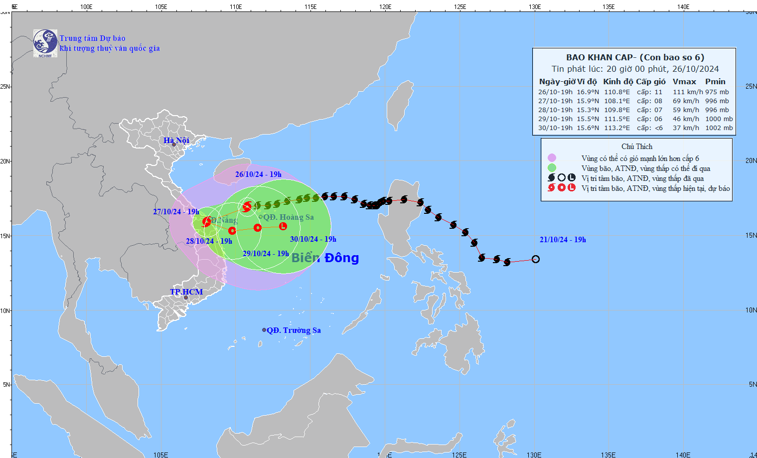
Forecast of storm No. 6's path, updated at 20:00 on October 26 (photo: National Center for Hydro-Meteorological Forecasting)
From now on, storm No. 6 will cause strong winds of level 6-7 for most of the Central Coast. Along with the movement of storm No. 6 closer to shore, the wind in Ly Son island area and the Central Coast will gradually increase to level 8, the area near the storm center will be strong at level 9-10, gusting at level 11-12.
Due to the impact of the storm, from the afternoon of October 26, the coastal and inland areas from Quang Tri to Quang Ngai will begin to experience showers and thunderstorms. The Central region will experience heavy rain with rainfall intensity of over 100 mm/3 hours, over 200 mm/6-12 hours. "Prolonged heavy rain as analyzed above will cause urban flooding as well as the risk of flash floods and landslides in the Central region," Mr. Nguyen Van Huong noted.
Regarding strong winds on land, Mr. Nguyen Van Huong said that from early morning and on October 27, the area from Quang Tri to Quang Nam had coastal winds of level 6-7, and near the storm center, winds of level 8-9. The strong winds appeared from the morning to the afternoon of October 27.
Specifically, at 4:00 p.m. on October 26, storm No. 6 moved west at a speed of about 20 km/h. By 4:00 p.m. on October 27, the storm moved west-southwest at a speed of 15 km/h, in the coastal waters of the Central Central region. The strongest wind speed is level 9, gusting to level 11. The affected areas are the western part of the North East Sea (including the Hoang Sa area), the Central Central sea, and the coastal mainland of the Quang Tri - Quang Nam region; disaster risk level 3.
At 4:00 p.m. on October 28, the storm moved in a South-Southeast direction then turned East at a speed of 5 km/h, in the sea off the Central Central region. The strongest wind was level 8, gusting to level 10. The affected area was the western part of the North East Sea (including the western part of Hoang Sa), the Central Central region, the mainland along the coast of Quang Tri - Quang Nam; disaster risk level 3.
At 4:00 p.m. on October 29, the storm moved east at a speed of 5-10 km/h and weakened into a tropical depression, about 130 km west-southwest of the Hoang Sa area. The strongest wind was level 7, gusting to level 9. The affected area was the west of the North East Sea (including the west of Hoang Sa), and the central central sea area.
From the next 72 to 120 hours, the tropical depression will move mainly eastward at 5-10 km per hour, continuing to weaken further.
Forecast of storm impact, the western sea area of the North East Sea has strong winds of level 8 - 9, near the storm's eye level 10 - 11 (89 - 117 km/h), gusts of level 14, waves 4 - 6 m high, near the storm's eye 8 m; rough seas.
The sea area of provinces from Quang Binh to Quang Ngai (including Con Co Island, Cu Lao Cham, Ly Son) has strong winds of level 6 - 7, then increasing to level 8, the area near the storm's eye has level 9 - 10, gusting to level 12, waves 2 - 4m high, the area near the storm's eye has 4 - 6m; the sea is very rough.
From the morning of October 27, the coastal areas from Quang Binh to Quang Nam are likely to experience storm surges of 0.4 - 0.6 m high. Ships operating in the above-mentioned dangerous areas (especially in the Hoang Sa area), coastal areas from Quang Binh to Quang Ngai are likely to be affected by storms, whirlwinds, strong winds, and large waves.
High risk of landslides of sea dikes and embankments along the coast of provinces from Quang Tri to Quang Nam due to the impact of big waves and rising water.
From the morning of October 27, on the mainland along the coast from Quang Binh to Quang Ngai, the wind will gradually increase to level 6-7, near the storm center level 8, gusting to level 11.
From the evening and night of October 26 to the night of October 28, the area from Quang Binh to Quang Ngai will have heavy to very heavy rain with total rainfall ranging from 300 mm - 500 mm, locally over 700 mm. Warning of the risk of localized heavy rain over 100 mm/3 hours. The areas of Ha Tinh, Binh Dinh and the Northern Central Highlands will have heavy rain, locally very heavy rain with total rainfall ranging from 100 - 200 mm, some places over 300 mm.
![[Photo] General Secretary To Lam attends the conference to review 10 years of implementing Directive No. 05 of the Politburo and evaluate the results of implementing Regulation No. 09 of the Central Public Security Party Committee.](https://vphoto.vietnam.vn/thumb/1200x675/vietnam/resource/IMAGE/2025/5/19/2f44458c655a4403acd7929dbbfa5039)
![[Photo] President Luong Cuong presents the 40-year Party membership badge to Chief of the Office of the President Le Khanh Hai](https://vphoto.vietnam.vn/thumb/1200x675/vietnam/resource/IMAGE/2025/5/19/a22bc55dd7bf4a2ab7e3958d32282c15)
![[Photo] Panorama of the Opening Ceremony of the 43rd Nhan Dan Newspaper National Table Tennis Championship](https://vphoto.vietnam.vn/thumb/1200x675/vietnam/resource/IMAGE/2025/5/19/5e22950340b941309280448198bcf1d9)


![[Photo] Close-up of Tang Long Bridge, Thu Duc City after repairing rutting](https://vphoto.vietnam.vn/thumb/1200x675/vietnam/resource/IMAGE/2025/5/19/086736d9d11f43198f5bd8d78df9bd41)


![[Photo] Prime Minister Pham Minh Chinh inspects the progress of the National Exhibition and Fair Center project](https://vphoto.vietnam.vn/thumb/1200x675/vietnam/resource/IMAGE/2025/5/19/35189ac8807140d897ad2b7d2583fbae)


![[VIDEO] - Enhancing the value of Quang Nam OCOP products through trade connections](https://vphoto.vietnam.vn/thumb/402x226/vietnam/resource/IMAGE/2025/5/17/5be5b5fff1f14914986fad159097a677)


Comment (0)