

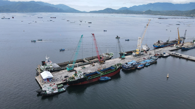
Storm No. 12 makes landfall with wind force level 6, gust level 8
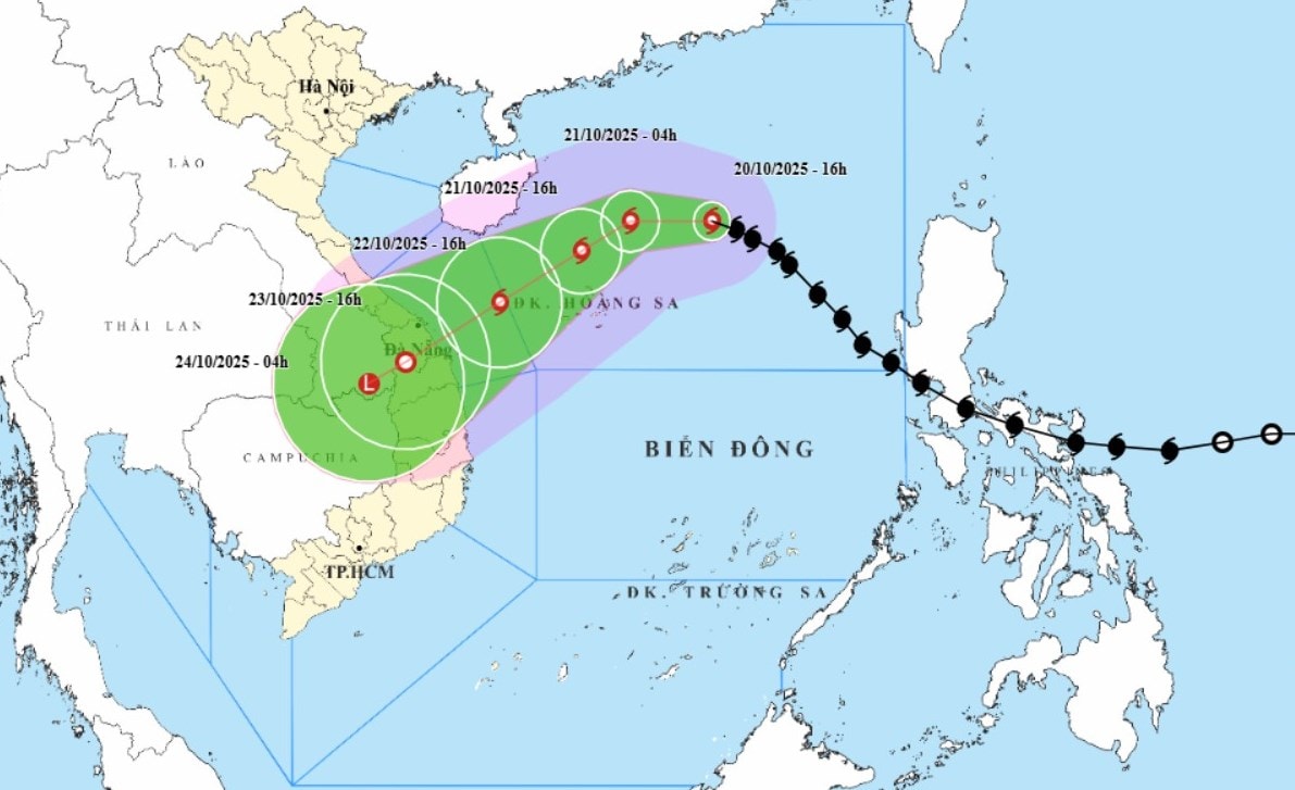
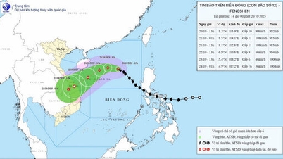
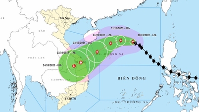
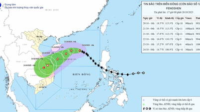
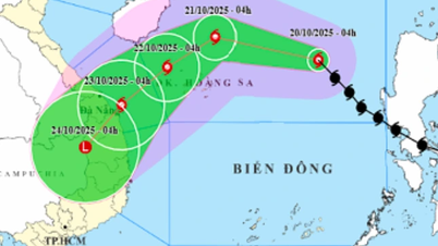
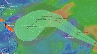
Currently, storm No. 12 (Fengshen) is moving west-northwest at a speed of about 20km/hour and has a tendency to strengthen, with wind intensity reaching level 11, gusting to level 13 in the next 24 hours.
Cold air from the north flowing down to the East Sea while the storm moves near the shore will strongly affect the direction and intensity of the storm.
The cold air flow causes the storm to gradually shift to the southwest and weaken rapidly as it approaches land.
Specifically, from October 22 onwards, when approaching the northwest sea area of Hoang Sa, the storm began to gradually change direction to the southwest, its speed decreased and gradually weakened before moving inland.
According to the latest forecast, storm No. 12 will make landfall in the area from Da Nang to Quang Ngai around October 23 with strong winds of level 6, gusts of level 8, then weaken into a tropical depression on land.
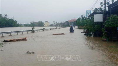
Very heavy rain over a wide area
Leaders of the National Center for Hydro-Meteorological Forecasting said that the storm circulation combined with cold air and easterly wind disturbances will cause very heavy rain over a wide area from the night of October 22 to October 26 in provinces and cities from Ha Tinh to Quang Ngai.
Accordingly, the area from Ha Tinh to the north of Quang Tri and Quang Ngai province has common rainfall from 200-400mm, in some places over 500mm.
From the south of Quang Tri to Da Nang city, rainfall ranges from 500-700 mm, locally over 900 mm.
Prolonged heavy rain can cause flash floods and landslides in mountainous areas and deep flooding in low-lying and urban areas.
“Although the storm weakened quickly after approaching the shore, its circulation combined with cold air will cause widespread rain and flooding.
Heavy rain in the Central region is likely to last until the end of October 2025," said Mr. Hoang Phuc Lam.
Regarding floods, from October 23 to 30, on rivers from Quang Tri to Quang Ngai, there will be a major flood, with peak water levels reaching or exceeding alert level 3, causing deep and widespread flooding, along with a high risk of flash floods and landslides.
Therefore, people in the Central region, especially provinces and cities from Ha Tinh to Quang Ngai, need to proactively prepare plans to prevent heavy rain, flooding and landslides, ensuring safety for people and property.
[VIDEO] - Comments on storm No. 12 and heavy rain. Source: Department of Hydrometeorology (Ministry of Agriculture and Environment)
Source: https://baodanang.vn/can-chu-dong-phong-tranh-mua-rat-lon-ngap-lut-sau-dien-rong-3306835.html

![[Photo] Prime Minister Pham Minh Chinh meets with Speaker of the Hungarian National Assembly Kover Laszlo](https://vphoto.vietnam.vn/thumb/1200x675/vietnam/resource/IMAGE/2025/10/20/1760970413415_dsc-8111-jpg.webp)
![[Photo] National Assembly Chairman Tran Thanh Man holds talks with Hungarian National Assembly Chairman Kover Laszlo](https://vphoto.vietnam.vn/thumb/1200x675/vietnam/resource/IMAGE/2025/10/20/1760952711347_ndo_br_bnd-1603-jpg.webp)
![[Photo] Chairman of the Hungarian Parliament visits President Ho Chi Minh's Mausoleum](https://vphoto.vietnam.vn/thumb/1200x675/vietnam/resource/IMAGE/2025/10/20/1760941009023_ndo_br_hungary-jpg.webp)

![[Photo] Solemn opening of the 10th Session, 15th National Assembly](https://vphoto.vietnam.vn/thumb/1200x675/vietnam/resource/IMAGE/2025/10/20/1760937111622_ndo_br_1-202-jpg.webp)


![[Photo] The Steering Committee of the 2025 Fall Fair checks the progress of the organization](https://vphoto.vietnam.vn/thumb/1200x675/vietnam/resource/IMAGE/2025/10/20/1760918203241_nam-5371-jpg.webp)


Comment (0)