

Vice Chairman of the City People's Committee Tran Nam Hung also noted that according to the forecast of the National Center for Hydro-Meteorological Forecasting and weather experts, from October 23 to 26, heavy rain will occur in Da Nang city, causing the risk of flash floods, landslides in mountainous areas and severe flooding in urban areas, plains and midlands.
Departments, branches, sectors and localities widely inform people to proactively prevent and proactively deploy response according to issued plans.
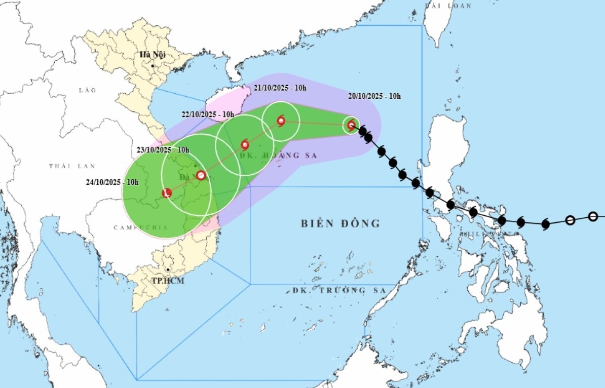
According to the National Center for Hydro-Meteorological Forecasting, at 10:00 a.m. on October 20, the center of storm No. 12 was at about 18.1 degrees north latitude, 116.3 degrees east longitude, about 460km east-northeast of Hoang Sa special zone with the strongest wind at level 9, gusting to level 11; the storm is moving rapidly in a northwest direction at a speed of 20-25km/hour and is likely to strengthen further.
At 10:00 a.m. on October 21, the eye of the storm was about 180km north of Hoang Sa special zone with the strongest wind at level 11, gusting to level 13.
Due to interaction with cold air, storm No. 12 changed direction to move west, then southwest with gradually weakening intensity.
At 10:00 a.m. on October 22, the storm's eye was located in the sea northwest of Hoang Sa special zone with the strongest wind at level 9-10, gusting to level 12.
The storm moved southwest at a speed of about 10-15km/h and gradually weakened into a tropical depression.
At 10:00 a.m. on October 23, the center of the tropical depression was at about 15.6 degrees north latitude, 108.4 degrees east longitude, on the mainland from Da Nang city to Quang Ngai province.

The North East Sea (including Hoang Sa special zone) has strong winds of level 7-8; the area near the storm's eye has strong winds of level 9-11, gusting to level 13; waves are 3-5m high, the area near the storm's eye is 5-7m high, the sea is very rough.
All ships and boats in the danger zone are at risk of being affected by storms, whirlwinds, strong winds and large waves.
Due to the influence of storm circulation and cold air combined with easterly wind disturbances, the effects of terrain and easterly winds after the storm, from October 22 to 27, on land from Ha Tinh to Quang Ngai, there is a high possibility of widespread heavy rain, lasting for many days, with some areas having very heavy rain; high risk of flash floods and landslides in mountainous areas, flooding in low-lying areas and urban areas.
Source: https://baodanang.vn/da-nang-kich-hoat-phuong-an-phong-chong-thien-tai-khong-de-lung-tung-va-bi-dong-3306800.html


![[Photo] General Secretary To Lam receives the Director of the Academy of Public Administration and National Economy under the President of the Russian Federation](/_next/image?url=https%3A%2F%2Fvphoto.vietnam.vn%2Fthumb%2F1200x675%2Fvietnam%2Fresource%2FIMAGE%2F2025%2F12%2F08%2F1765200203892_a1-bnd-0933-4198-jpg.webp&w=3840&q=75)


Comment (0)