
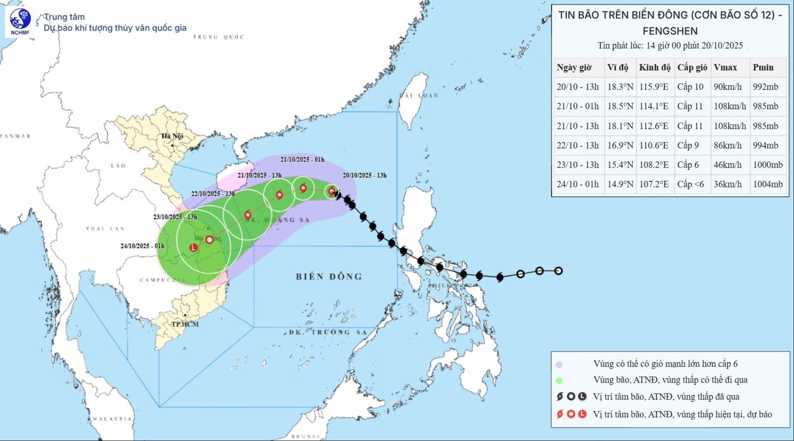
According to the National Center for Hydro-Meteorological Forecasting, at 4:00 p.m. on October 20, the eye of the storm was located at about 18.5 degrees North latitude; 115.3 degrees East longitude, about 380km East Northeast of Hoang Sa special zone. The strongest wind near the eye of the storm was level 9-10 (75-102km/h), gusting to level 12. Moving in the West Northwest direction, speed about 20km/h.
Forecast, by 13:00 on October 21, the storm will move westward, at a speed of 10 - 15 km/h, the storm's location is at 18.1N-112.6E; about 170 km north of Hoang Sa special zone, the storm is likely to strengthen, with a storm intensity of level 11, gusting to level 13, the danger zone is 16.50N-20.50N; 110.50E-118.00E, natural disaster risk level 3, the affected area is the North East Sea (including Hoang Sa special zone).
Forecast at 1:00 p.m. on October 22, the storm is moving southwest, at a speed of about 10 km/h, located at 16.9N-110.6E; in the sea northwest of Hoang Sa special zone. The storm is likely to weaken, with a strong storm intensity of level 9, gusting to level 11, the danger zone is 15.50N-20.50N; 109.00E-115.00E, disaster risk level 3, the affected area is the sea west of the North East Sea (including Hoang Sa special zone), the sea from South Quang Tri to Quang Ngai.
At 1:00 p.m. on October 23, the storm moved southwest at a speed of 10-15 km/h, located at 5.4N-108.2E; on the mainland of Da Nang - Quang Ngai City. The storm is likely to gradually weaken into a tropical depression, with a storm intensity of level 6, gusts of level 8, the danger zone is 14.50N-19.00N; west of longitude 113.00E, disaster risk level 3, the affected area is the sea west of the North East Sea (including Hoang Sa special zone), the sea from South Quang Tri to Quang Ngai (including Ly Son special zone).
Warning, from the next 72 to 84 hours, the tropical depression will move mainly in the southwest direction, about 10 km per hour, go deep inland and gradually weaken into a low pressure area.
At sea, the North East Sea area (including Hoang Sa special zone) has strong winds of level 7-8; the area near the storm's eye has strong winds of level 9-11, gusting to level 13; waves are 3-5 m high, the area near the storm's eye is 5-7 m high. The sea is very rough. All ships and boats in the danger zone are at risk of being affected by storms, whirlwinds, strong winds and big waves.
On land, due to the influence of storm circulation and cold air combined with East wind disturbances, terrain effects and East wind after the storm, from the night of October 22 to October 26, the area from Ha Tinh to Quang Ngai is likely to have widespread heavy rain.
Total rainfall in Ha Tinh to Northern Quang Tri and Quang Ngai is about 200 - 400 mm, locally over 500 mm; in the area from Southern Quang Tri to Da Nang City, it is commonly 500 - 700 mm, locally over 900 mm.
Heavy rains in the Central region are likely to last until the end of October. There is a high risk of flash floods and landslides in mountainous areas, flooding in low-lying areas and urban areas. Localities need to pay attention to the safe operation of hydroelectric and irrigation reservoirs before, during and after the storm, and prepare response plans for flood scenarios on rivers from Quang Tri to Quang Ngai that may reach and exceed alert level 3. The forecast level of natural disaster risk due to floods and inundations is level 3.
Source: https://baohaiphong.vn/bao-so-12-tiep-tuc-manh-len-huong-vao-mien-trung-524128.html


![[Photo] Cat Ba - Green island paradise](/_next/image?url=https%3A%2F%2Fvphoto.vietnam.vn%2Fthumb%2F1200x675%2Fvietnam%2Fresource%2FIMAGE%2F2025%2F12%2F04%2F1764821844074_ndo_br_1-dcbthienduongxanh638-jpg.webp&w=3840&q=75)


Comment (0)