
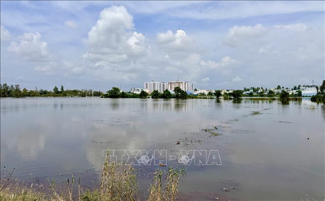
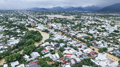
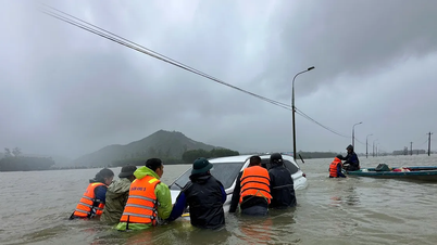
Accordingly, the water level in the downstream of Hau River in Long Xuyen, An Giang province is rising following the high tide in early October of the lunar calendar. The peak tide is likely to reach 255 - 265cm, 5 - 15cm above alert level 3 and cause flooding in many communes and wards in An Giang province.
According to the An Giang Province Hydrometeorological Station, the peak tide in the lower reaches of the Hau River will occur from November 21 to 22, which is the 1st to 3rd of the 10th lunar month. The highest water level at Long Xuyen station on the Hau River on November 18 is forecast to be 232cm, and on November 19 it will be 240cm. On November 20, the highest water level at Long Xuyen station on the Hau River will be recorded at 250cm.
Due to the appearance of tidal peaks in the lower reaches of the Hau River, rising water levels are likely to cause flooding and local inundation in some low-lying areas, riverside areas, canals, ditches, and vulnerable culverts in urban areas in Long Xuyen, Binh Duc, My Thoi wards and My Hoa Hung commune, An Giang province.
According to the warning, Long Xuyen ward is likely to experience flooding and localized waterlogging in the embankment area, along the Hau River, and Rach Gia Long Xuyen canal. Binh Duc ward is flooded in Binh Khanh 5 and Binh Khanh 7 hamlets; My Thoi ward is flooded in the Hoi Dong, Rach Goi Be, Cai Sao - Bo Ho canals and My Hoa Hung commune is flooded in low-lying areas along the Hau River. The flooding time is forecast to occur from 4am to 7am. The maximum flooding depth is from 5 - 20cm. Warning level of natural disaster risk due to flooding is at level 2
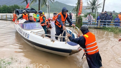
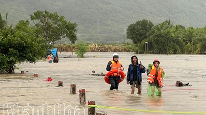
The An Giang Province Hydrometeorological Station also warned that the Hau River area through Long Xuyen Ward has a large width, deep river, strong flow speed and large, deep flooded areas. When strong winds occur, it can create large waves causing erosion and landslides on river banks, canals and ditches. Therefore, the locality needs to have a plan to prevent and combat landslides on river banks, canals and ditches to limit the impact on traffic activities, aquaculture, agricultural production and socio- economic activities of the people.
In the past 24 hours, there has been little rain in Long Xuyen, Binh Duc, My Thoi wards and My Hoa Hung commune. Water levels on Tien and Hau rivers have been slowly decreasing. By the end of November 17, the highest water level on Hau river in Long Xuyen was 234 cm, 16 cm below alert level 3.
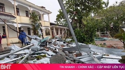
Due to the impact of high tides on the Hau River, on the afternoon of November 17, the east bank of the Hau River, in Vinh Phuoc Hamlet, Phu Huu Commune, An Giang Province, recorded two riverbank landslides with a total length of about 170m, 3-6m deep into the mainland. The landslides affected 13 houses; of which 4 completely collapsed into the river, 1 partially collapsed and 8 houses had to be urgently relocated. The initial damage is estimated at over 300 million VND.
Source: https://baotintuc.vn/kinh-te/canh-bao-vung-ha-luu-song-hau-xuat-hien-dinh-trieu-tren-bao-dong-3-tu-ngay-21-2211-20251118183444194.htm

![[Photo] Prime Minister Pham Minh Chinh and his wife meet the Vietnamese community in Algeria](https://vphoto.vietnam.vn/thumb/1200x675/vietnam/resource/IMAGE/2025/11/19/1763510299099_1763510015166-jpg.webp)


![[Photo] General Secretary To Lam receives Slovakian Deputy Prime Minister and Minister of Defense Robert Kalinak](https://vphoto.vietnam.vn/thumb/1200x675/vietnam/resource/IMAGE/2025/11/18/1763467091441_a1-bnd-8261-6981-jpg.webp)


Comment (0)