
 |
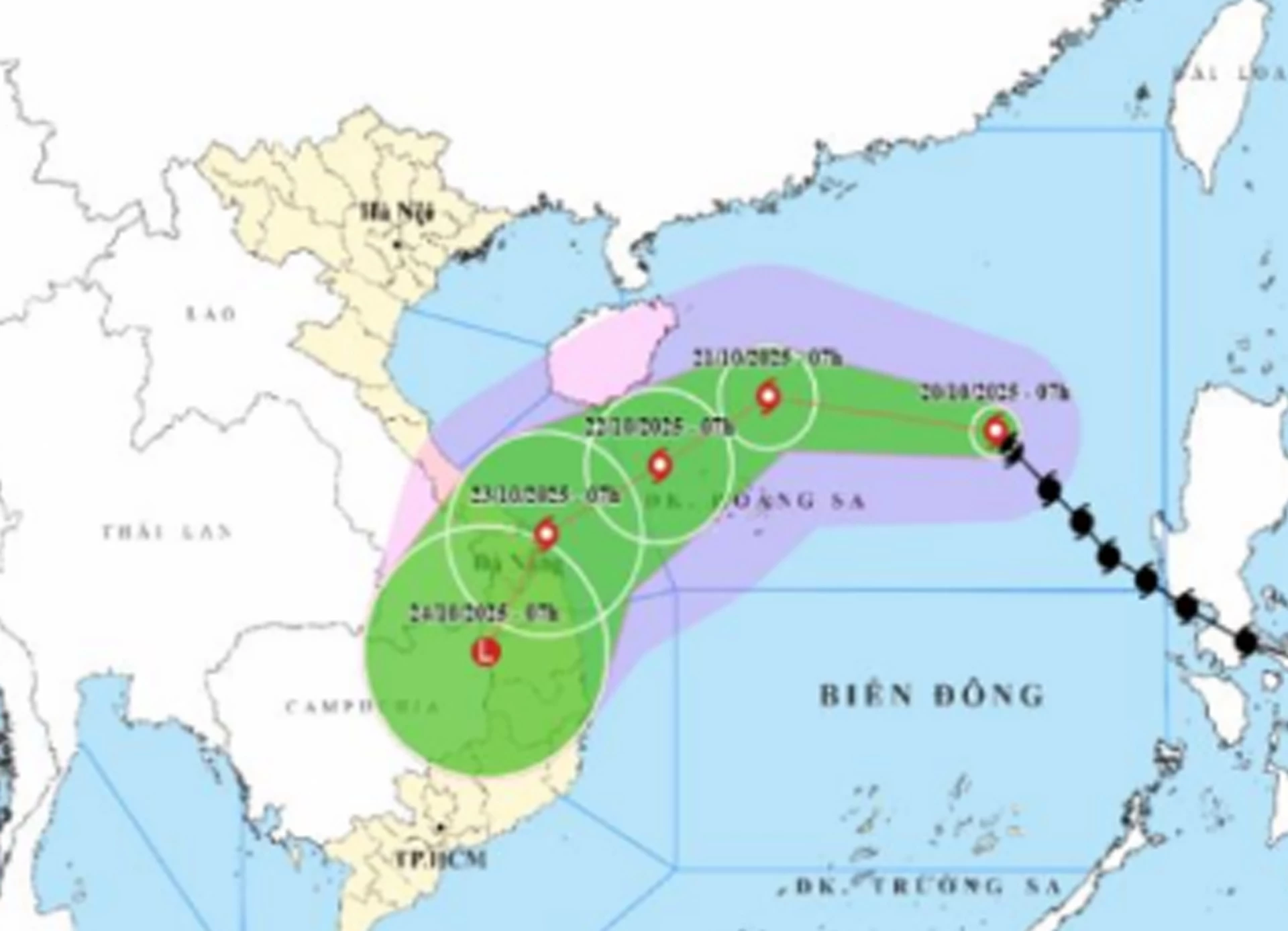
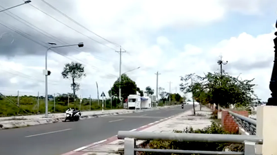
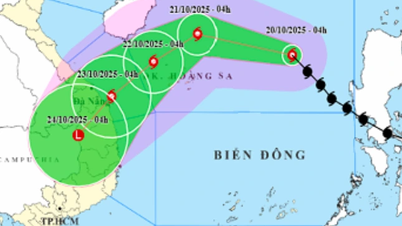
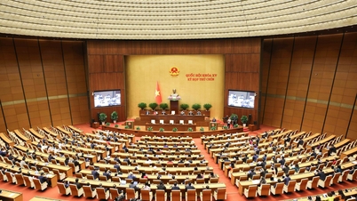
| Location and forecast direction of storm number 12. |
Due to the storm's influence, the northern East Sea (including Hoang Sa special zone) has strong winds of level 7-8; the area near the storm's eye has strong winds of level 9-11, gusting to level 13; waves 3-5m high, the area near the storm's eye has waves of 5-7m high, and the sea is very rough. All ships and boats operating in the above-mentioned dangerous areas are likely to be affected by storms, whirlwinds, strong winds, and large waves.
On land, it is forecasted that from October 22 to 27, the area from Ha Tinh to Quang Ngai is likely to have widespread heavy rain lasting for many days, with some areas having very heavy rain, with a high risk of flash floods and landslides in mountainous areas. Localities need to prepare response plans for flood scenarios on rivers from Quang Tri to Quang Ngai that may reach and exceed alert level 3.
In Khanh Hoa , according to the thunderstorm warning bulletin at 6:30 a.m. on October 20 of the Khanh Hoa Provincial Hydrometeorological Station, through monitoring on weather radar images, convective clouds are developing in the villages and neighborhoods of the following communes and wards: Tu Bong, Tay Ninh Hoa, Tan Dinh, Bac Khanh Vinh, Trung Khanh Vinh, Nam Khanh Vinh, Khanh Vinh, Suoi Hiep, Dien Lam, Dien Dien, Bac Nha Trang, Nha Trang, Nam Nha Trang, Nam Ninh Hoa and the sea off the coast of Khanh Hoa province. In the next 6 hours, convective clouds will continue to develop, causing showers and thunderstorms in the above-mentioned area, then expanding to the whole province. During thunderstorms, beware of lightning, tornadoes, hail and strong gusts of wind; rapid water flowing over spillways and spillways; localized heavy rain causing flooding in low-lying areas, urban areas, flash floods, landslides in steep slopes and mountainous areas. Recommend that agencies, departments, branches and people pay attention to prevention and ensure safety.
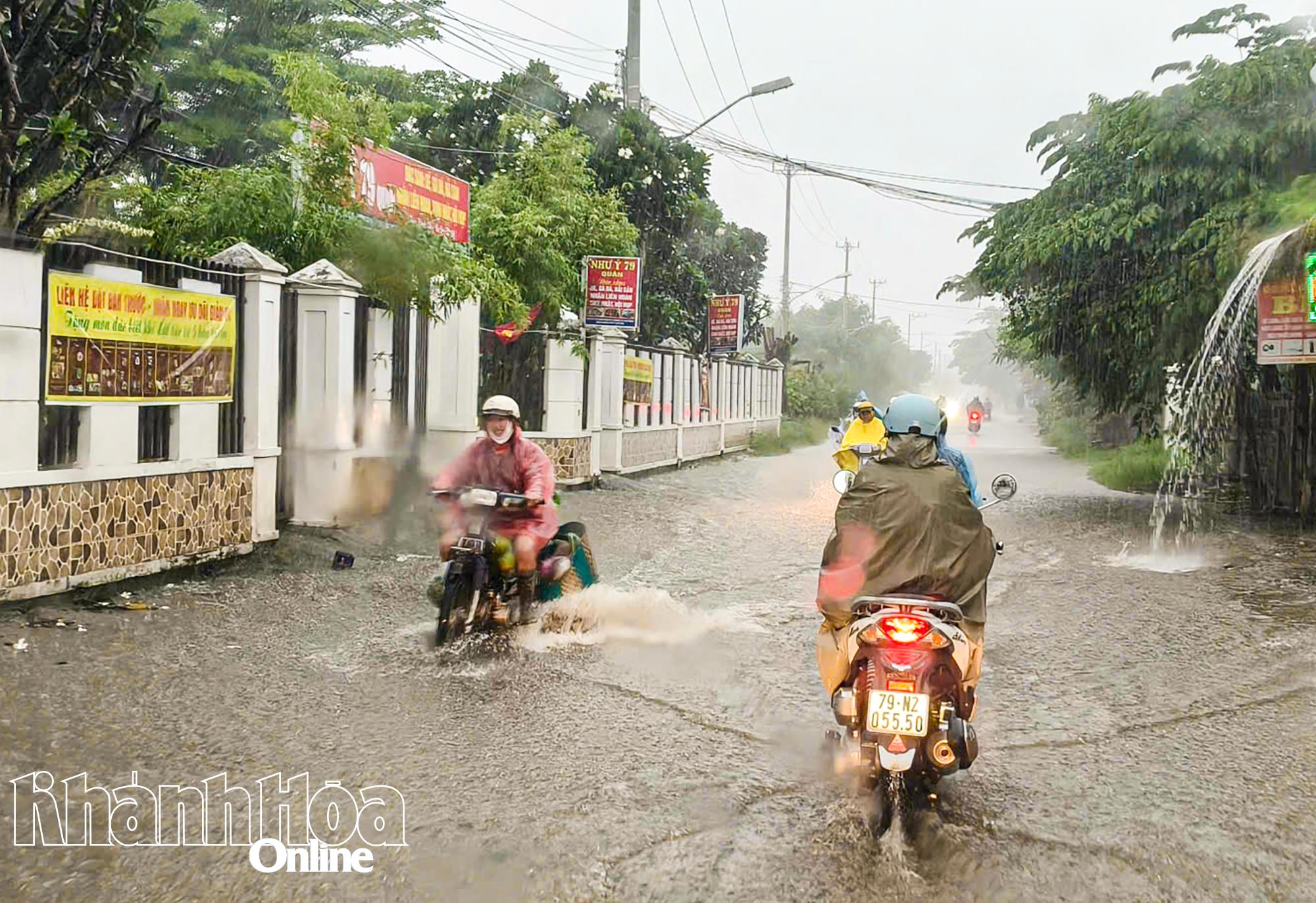 |
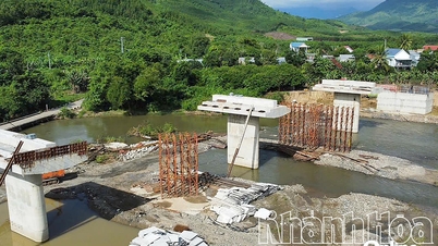
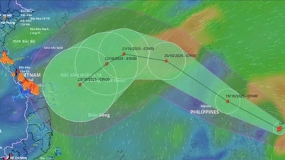
| Heavy rain in Khanh Hoa province in recent days. |
Previously, on the afternoon of October 19, the National Civil Defense Steering Committee sent a telegram to the People's Committees of coastal provinces and cities from Quang Ninh to Lam Dong; the Ministries of National Defense, Public Security, Agriculture and Environment, Construction, Industry and Trade, Foreign Affairs, Science and Technology; Vietnam Television, Voice of Vietnam , and Vietnam News Agency on proactively responding to storm No.
The telegram requires ministries, branches and People's Committees of coastal provinces and cities from Quang Ninh to Lam Dong to closely monitor the storm's developments; strictly manage vessels going out to sea; organize counting and notify owners of vessels and captains of ships and boats operating at sea of the location, direction of movement and developments of the storm to proactively avoid, escape or not move into dangerous areas; be ready with forces and means for rescue when requested. News agencies, newspapers, coastal information systems and mass media agencies from central to local levels to increase information on the storm's developments to authorities at all levels, owners of vessels operating at sea and people to proactively respond. Ministries and branches, according to their functions, state management tasks and assigned tasks, proactively direct and coordinate with localities to respond to the storm.
H.D
Source: https://baokhanhhoa.vn/xa-hoi/202510/chu-dong-ung-pho-bao-so-12-tren-bien-dong-va-mua-lon-tren-dia-ban-tinh-6cc246a/

![[Photo] Chairman of the Hungarian Parliament visits President Ho Chi Minh's Mausoleum](https://vphoto.vietnam.vn/thumb/1200x675/vietnam/resource/IMAGE/2025/10/20/1760941009023_ndo_br_hungary-jpg.webp)
![[Photo] National Assembly Chairman Tran Thanh Man holds talks with Hungarian National Assembly Chairman Kover Laszlo](https://vphoto.vietnam.vn/thumb/1200x675/vietnam/resource/IMAGE/2025/10/20/1760952711347_ndo_br_bnd-1603-jpg.webp)
![[Photo] Solemn opening of the 10th Session, 15th National Assembly](https://vphoto.vietnam.vn/thumb/1200x675/vietnam/resource/IMAGE/2025/10/20/1760937111622_ndo_br_1-202-jpg.webp)
![[Photo] Prime Minister Pham Minh Chinh meets with Speaker of the Hungarian National Assembly Kover Laszlo](https://vphoto.vietnam.vn/thumb/1200x675/vietnam/resource/IMAGE/2025/10/20/1760970413415_dsc-8111-jpg.webp)


![[Photo] The Steering Committee of the 2025 Fall Fair checks the progress of the organization](https://vphoto.vietnam.vn/thumb/1200x675/vietnam/resource/IMAGE/2025/10/20/1760918203241_nam-5371-jpg.webp)


Comment (0)