
(VTC News) – Trami weakened into a tropical depression, and it is not possible to rule out the possibility that typhoon Kong-Rey, which is active in the sea far east of Luzon Island, will approach the East Sea.
Mr. Vu Anh Tuan - Deputy Head of Weather Forecast Department, National Center for Hydro-Meteorological Forecasting gave initial comments on storm Kong-rey
The National Center for Hydro-Meteorological Forecasting said that on the afternoon of October 27, after moving deep into the mainland provinces of Thua Thien Hue, Quang Nam - Da Nang , storm Trami (storm No. 6) weakened into a tropical depression (ATND).
At 4:00 p.m., the center of the tropical depression was located on the mainland of Thua Thien Hue, Quang Nam - Da Nang provinces. The strongest wind near the center of the tropical depression was level 7 (50-61 km/h), gusting to level 9 and moving in the South-Southwest direction, at a speed of about 5 km/h.
From last night to this afternoon (October 27), Ha Tinh - Quang Nam had heavy to very heavy rain. Total rainfall by 4pm the same day was generally 150-250mm, locally over 400mm.
“The tropical depression is moving south. In the coming hours, the tropical depression is likely to move out to sea and may weaken into a low pressure area over the central central sea area,” said Mr. Vu Anh Tuan, Deputy Head of the Weather Forecast Department, National Center for Hydro-Meteorological Forecasting.
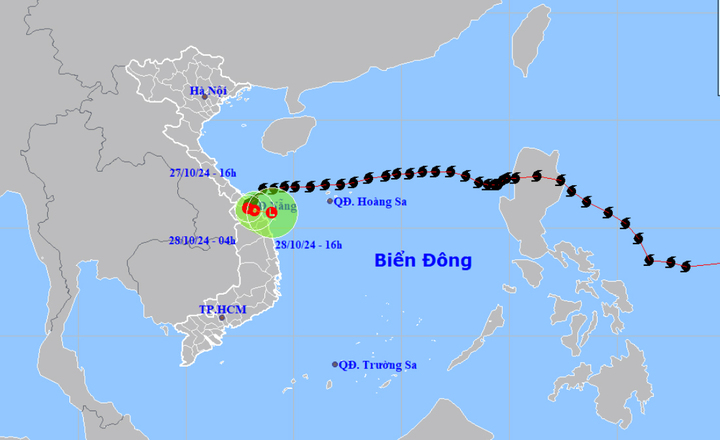
This afternoon, October 27, storm Trami weakened into a tropical depression. (Source: NCHMF)
Typhoon Kong-Rey is currently active in the seas off the eastern coast of Luzon Island (Philippines). As of 1 p.m. on October 27, the storm was about 1,000 km from shore and continued to strengthen.
According to the initial assessment of the National Center for Hydro-Meteorological Forecasting, this storm continues to move west and deviate to the right. However, recent products have shown that the development of this storm tends to deviate to the left, with a lower possibility than the initial assessment.
“Therefore, it is not impossible that this storm will approach the East Sea. The National Center for Hydro-Meteorological Forecasting is closely monitoring this storm and will provide further information in the coming time,” said Mr. Tuan.
Flood warning on rivers in Central Vietnam
Mr. Phung Tien Dung, Head of Hydrological Forecasting Department, National Center for Hydro-Meteorological Forecasting also issued a warning about floods on rivers in the Central region.
Due to heavy rain in the Central Central region, floods on rivers in the provinces of Quang Binh, Quang Tri, and Thua Thien Hue are rising very quickly.
This afternoon, the water level on the Giang River in Quang Binh exceeded alert level 3 by about 0.5m; rivers in Quang Tri were at alert level 2-3, some rivers exceeded alert level 3; rivers in Thua Thien Hue rose above alert level 2, especially the Huong River.
“Heavy rain and rapid floods have caused flooding in Le Thuy, Quang Ninh districts and Dong Hoi city (Quang Binh province); Trieu Phong, Hai Lang, Gio Linh, Dong Ha city and Quang Tri town (Quang Tri province). In Thua Thien Hue, flooding has occurred in Phu Loc, Phu Vang, Huong Thuy, Huong Tra districts and Hue city,” Mr. Dung informed.
According to the meteorological agency, from now until October 29, floods on rivers in Quang Binh and Quang Tri are likely to reach level 2-3, with some rivers above level 3. There is a high risk of landslides in mountainous areas, riverbank landslides, and localized flooding in low-lying areas along rivers and urban areas in provinces from Quang Binh to Thua Thien Hue.
Vtcnews.vn
Source: https://vtcnews.vn/chuyen-gia-nhan-dinh-kha-nang-bao-kong-rey-vao-bien-dong-sau-trami-ar904183.html


![[Photo] Prime Minister Pham Minh Chinh attends the event "Digital transformation of the banking industry by 2025"](https://vphoto.vietnam.vn/thumb/1200x675/vietnam/resource/IMAGE/2025/5/29/0e34cc7261d74e26b7f87cadff763eae)


![[Photo] Prime Minister Pham Minh Chinh receives leaders of Excelerate Energy Group](https://vphoto.vietnam.vn/thumb/1200x675/vietnam/resource/IMAGE/2025/5/29/c1fbe073230443d0a5aae0bc264d07fe)


Comment (0)