
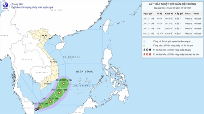
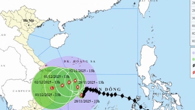
According to the forecast of the National Center for Hydro-Meteorological Forecasting, at 10:00 p.m. on November 27, the eye of the storm was about 220 km northwest of Song Tu Tay Island. The strongest wind near the eye of the storm was level 12 (118-133 km/h), gusting to level 15. Moving west at a speed of 5-10 km/h.
Forecast until 10pm on November 28, the storm is in the western sea area of the central East Sea, about 260km northwest of Song Tu Tay Island. The storm is moving west-southwest at a speed of about 3-5km/h. The strongest wind is level 11, gusting to level 14. The affected area is the central East Sea area (including the northern sea area of Truong Sa special zone), with a natural disaster risk level of level 3.
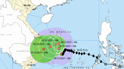
By 10 p.m. on November 29, the storm was in the western sea area of the central East Sea. The storm moved northwest at a speed of about 3-5 km/h, gradually weakening. The strongest wind was level 10, gusting to level 13. The affected area was the western sea area of the central East Sea (including the northwest sea area of Truong Sa special zone), the sea area off the coast of provinces from Gia Lai to Khanh Hoa, with a level 3 natural disaster risk.
By 10 p.m. on November 30, the storm was in the northwest sea area of the central East Sea. The storm moved northwest at a speed of about 3-5 km/h, gradually weakening in intensity. The strongest wind was level 9, gusting to level 13. The affected area was the western sea area of the central East Sea, the sea area off the coast of the provinces from Quang Ngai to Dak Lak, with a level 3 natural disaster risk.
From the next 72 to 120 hours, the storm will move slowly in the West-Northwest direction, then likely change direction to the West at a speed of 5-10 km/h and continue to weaken.
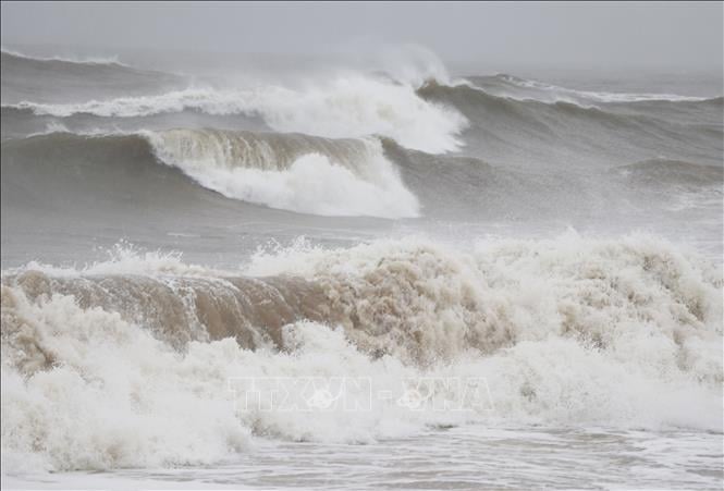
Due to the impact of the storm, the central East Sea area (including the sea area north of Truong Sa special zone) has strong winds of level 7-9; the area near the storm's eye has strong winds of level 10-12, gusting to level 15; waves 4-6m high, the area near the storm's eye 7-9m; the sea is very rough.
From early morning and on November 28, the offshore sea area from Gia Lai to Khanh Hoa had strong winds of level 6-7, then increased to level 8, gusts of level 9-10, waves 5-7m high, rough seas.
Vessels operating in the above mentioned dangerous areas are susceptible to the impact of storms, whirlwinds, strong winds and large waves.
Source: https://baotintuc.vn/van-de-quan-tam/do-anh-huong-cua-bao-so-15-vung-bien-tu-gia-lai-den-khanh-hoa-co-gio-manh-song-cao-20251128060335208.htm


Comment (0)