
Will it be rainy and cold during the Lunar New Year of the Year of the Snake (2015)?
Regarding the weather forecast for the Lunar New Year of the Year of the Snake (2015), Mr. Hoang Phuc Lam, Deputy Director of the National Center for Meteorological and Hydrological Forecasting, stated that during the main Tet holiday period (January 27-31, or the 28th to the 3rd day of the Lunar New Year), the North will be affected by the Northeast monsoon, with temperatures approximately at the average level of previous years, cold weather, and severe cold in mountainous areas. The eastern part of the North will experience light rain and drizzle on some days.
The North Central region will experience light rain in some areas and cold weather. The Central and South Central regions will have scattered rain and showers (rain concentrated before January 28th (29th of the Lunar New Year). The Central Highlands and Southern Vietnam: Generally little rain and sunny weather (no heatwaves).
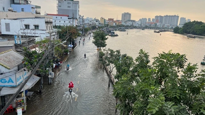
During the 2025 Lunar New Year holiday, the coastal areas of southeastern Vietnam will be affected by a high tide event from January 30th to February 2nd, 2025 (the 2nd to 5th day of the Lunar New Year). The highest tide during this event could reach 4.1m, causing localized flooding in some coastal and estuary areas.

The Lunar New Year of the Year of the Snake (2015) may bring a verstärkt cold front, with cold weather, severe cold in mountainous areas, and light rain or drizzle on some days in the northeastern part of Northern Vietnam. (Photo: DV)
During the Lunar New Year of the Year of the Snake (2015), there is a very low chance of tropical cyclones forming in the East Sea; in the period before Tet, from January 17-25 (18-26th of the 12th lunar month), the Northern region will have light fog in the morning, sunny and dry days, and continued cold weather; the Central region, from Thanh Hoa to Hue, will be cloudy and cold; the area from Da Nang to Binh Thuan in the North will be cold at night and in the morning, with light sunshine during the day; the Central Highlands and Southern region will have cloudy nights and early mornings with fog and light mist, sunny days, and no heatwaves.
What will the meteorological and hydrological situation be like in 2025?
Regarding the meteorological and hydrological situation in 2025, Mr. Mai Van Khiem, Director of the National Center for Meteorological and Hydrological Forecasting, stated that with the La Nina and ENSO phenomena, we assess that unseasonal rains in the early months of 2025 will occur with a higher probability than the multi-year average, with the possibility of early rains in the Central Highlands and Central regions…
Regarding the activity of typhoons and tropical depressions in 2025, Mr. Hoang Phuc Lam predicted that the typhoon season in the East Sea region is likely to be similar to the multi-year average (around June), and the number of typhoons/tropical depressions in the East Sea region and affecting the mainland is likely to be approximately at the multi-year average (the multi-year average in the East Sea is about 11-13 storms, affecting the mainland about 5-6 storms).
The likelihood of hot weather is similar to the multi-year average: hot weather is likely to begin in the Southern and Central Highlands regions around the first half of March; in the Northwest of Northern Vietnam and the mountainous areas of Northwest Central Vietnam around April; and in the Northeast of Northern Vietnam and the coastal areas of Central Vietnam from around May onwards. It is highly likely that the hot weather in 2025 will not be as intense or prolonged as in 2024.

Mr. Hoang Phuc Lam, Deputy Director of the National Center for Meteorological and Hydrological Forecasting, provided information on the weather situation during the Lunar New Year of the Year of the Snake (2015) and the meteorological and hydrological situation in 2025. Photo: The Kha.
Forecasts indicate that cold air activity will be similar to the average of previous years, so there is a possibility of severe cold spells and frost during the period from January to March 2025. In particular, there is a need to be prepared for strong cold fronts that could cause widespread severe cold, frost, and ice in the northern mountainous regions.
In 2025, the number of widespread heavy rainfall events across the country will be approximately at the multi-year average (around 20 events). These widespread heavy rainfall events are likely to begin in June in the North, then gradually move south and end around December in the Central provinces.
High tides along the southeastern coast of Vietnam: The southeastern coastal region experienced six periods of high tides on March 1-6, March 28-April 3, April 27-May 3, October 7-13, November 4-10, and December 4-10. During these periods, the water level at the Vung Tau station could reach over 4.3 meters.
During the dry season of early 2025, saltwater intrusion in the Mekong Delta will be higher than the multi-year average. From February to April 2025, saltwater intrusion will increase, affecting people's lives and agriculture in the localities. However, the saltwater intrusion will not be as severe as during the dry seasons of 2015-2016 and 2019-2020.
From March to July 2025, localized drought and water shortages outside the irrigation system's water supply area are likely to occur in the provinces from Phu Yen to Binh Thuan, Kon Tum, Gia Lai, and Dak Lak.
2024, a special year for the meteorological and hydrological sector.
Mr. Hoang Duc Cuong, Deputy Director General of the General Department of Meteorology and Hydrology, stated: "2024 is a very special year for the meteorological and hydrological sector. The year started with El Nino and ended with a cold phase of La Nina. All weather patterns were evident in 2024: hot weather at the beginning of the year, followed by heavy rainfall at the end, especially storms and floods, exemplified by Typhoon No. 3 which occurred at the end of the rainy season in Northern Vietnam."
Accordingly, the number of storms in 2024 was approximately average, with 10 typhoons and 1 tropical depression, but there were very strong storms and super typhoons that caused significant impacts. Among them, Typhoon Yagi, considered the strongest typhoon in the East Sea in 30 years, severely affected Quang Ninh and Hai Phong, causing strong winds of level 10-12, gusts of level 13-15, with the Bai Chay station experiencing winds of level 14, gusts of level 17. The northeastern provinces experienced strong winds of level 8-10, gusts of 12-14. Hanoi experienced strong winds of level 6-7, gusts of level 9.
In 2024, five widespread floods occurred in the northern provinces, from Thanh Hoa to Quang Ngai. Particularly from September 7-15, due to the influence of the remnants of Typhoon No. 3 (Yagi), most rivers in the North experienced one major flood, including historical floods such as on the Thao River in Lao Cai, Bao Ha, and Yen Bai… The water level in the lower Red River in Hanoi reached 11.30m, 0.2m below Flood Level 3 (a historical level in the past 20 years), while the water level in the lower Thai Binh River at Pha Lai reached 6.25m, 0.25m above Flood Level 3, the highest flood peak since 2003.
Widespread flooding occurred in 20 out of 25 northern provinces and cities. Due to heavy rains during Typhoon No. 3, a series of flash floods and landslides occurred in the mountainous provinces of Northern Vietnam, the most serious being the devastating flash flood that occurred on the morning of September 10, 2024, in Lang Nu village, Phuc Khanh commune, Bao Yen district, Lao Cai province.
![[Photo] Prime Minister Pham Minh Chinh holds a phone call with the CEO of Russia's Rosatom Corporation.](/_next/image?url=https%3A%2F%2Fvphoto.vietnam.vn%2Fthumb%2F1200x675%2Fvietnam%2Fresource%2FIMAGE%2F2025%2F12%2F11%2F1765464552365_dsc-5295-jpg.webp&w=3840&q=75)

![[Photo] Closing Ceremony of the 10th Session of the 15th National Assembly](/_next/image?url=https%3A%2F%2Fvphoto.vietnam.vn%2Fthumb%2F1200x675%2Fvietnam%2Fresource%2FIMAGE%2F2025%2F12%2F11%2F1765448959967_image-1437-jpg.webp&w=3840&q=75)


![[OFFICIAL] MISA GROUP ANNOUNCES ITS PIONEERING BRAND POSITIONING IN BUILDING AGENTIC AI FOR BUSINESSES, HOUSEHOLDS, AND THE GOVERNMENT](https://vphoto.vietnam.vn/thumb/402x226/vietnam/resource/IMAGE/2025/12/11/1765444754256_agentic-ai_postfb-scaled.png)


Comment (0)