
For the first time, a team of researchers has created a 3D replica of the Titanic wreck with millimeter accuracy.
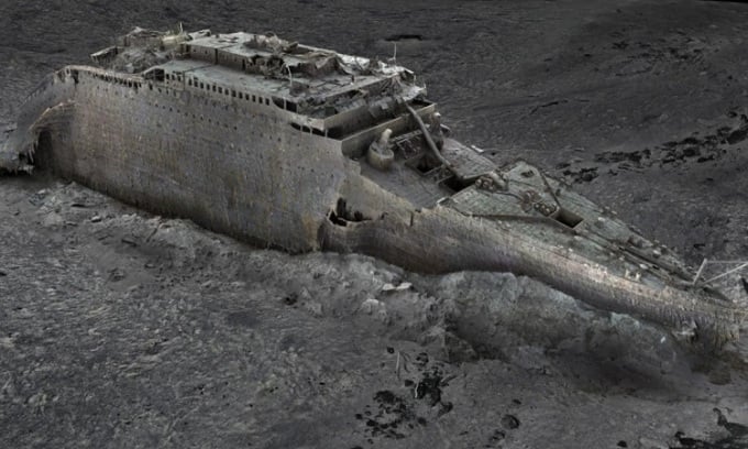
The team could use the scan data to find out the real mechanism behind the Titanic tragedy. Photo: Atlantic Productions/Magellan
Historians now believe a new underwater scanning project could provide answers to some of the unanswered questions surrounding the tragedy that killed more than 1,500 people. A team of scientists used deep-sea mapping to create the first-ever accurate digital replica of the Titanic wreck, Magellan and filmmaker Atlantic Productions announced on May 17.
By conducting the “largest underwater scanning project in history,” scientists are able to reveal details of the tragedy and uncover fascinating information about what really happened to the crew and passengers on the fateful night of April 14, 1912. The scan will take place in the summer of 2022 by a specialized ship stationed 700 km off the coast of Canada. Strict regulations prevent team members from touching or disturbing the wreck. Investigators stress that they are treating the wreck with the utmost respect.
Every millimeter of the 3 miles (4.8 km) of debris field was mapped in detail. The final digital replica successfully recreated the entire wreck, including the bow and stern sections that split when the ship sank in 1912. Parks Stephenson, who has studied the Titanic for 20 years, said the project revealed details never seen before. "We've got real data that engineers can use to examine the real mechanisms behind the breakup and sinking of the ship, and that's getting closer to the real story behind the Titanic disaster," Stephenson said. One example is the ship's propeller, where the serial number is visible for the first time in decades.
The team collected about 715,000 photos and 16 terabytes of data during the expedition. Magellan estimates that the digital replica is about 10 times larger than any previous underwater 3D model. According to Richard Parkinson, CEO of Magellan, the mission was difficult because the team had to contend with bad weather and technical challenges. While previous optical images of the ship were limited by the low light at 12,000 feet (3,810 meters) underwater, the new mapping technique effectively eliminates the effects of water and makes good use of light.
According to 3D imaging expert Gerhard Seiffert, the high-precision 3D model allows people to zoom in and examine the entire wreck for the first time. This map will open a new chapter in research and exploration of the Titanic, according to Stephenson.
An Khang (According to CNN )
Source link


![[Photo] National Assembly Chairman attends the seminar "Building and operating an international financial center and recommendations for Vietnam"](https://vphoto.vietnam.vn/thumb/1200x675/vietnam/resource/IMAGE/2025/7/28/76393436936e457db31ec84433289f72)


Comment (0)