In the data era, maps are not only a positioning tool but have become an important “digital infrastructure”, helping to connect all socio-economic sectors, serving national digital transformation, building a digital government, while ensuring national defense, security and territorial sovereignty . The Department of Surveying, Mapping and Geographic Information of Vietnam is playing a central role in this journey.
National Geographic Data Base - A Step Forward in Digital Transformation
Implementing Decision 40/QD-TTg of the Prime Minister , in just 3 years (2020-2022), the Department of Surveying, Mapping and Geographic Information of Vietnam has completed the construction of a national geographic database at scales of 1:25,000 to 1:1,000,000, covering the entire mainland and sea areas of Vietnam. This is the first time Vietnam has had a complete, modern and unified geographic database system, creating the foundation for a series of other national databases.

Photo of baseline and orientation marker A2 present on Hon Da Le in Hon Khoai island cluster ( Ca Mau province). This is not only the clearest evidence in the declaration of the Government of the Socialist Republic of Vietnam on the baseline used to calculate the width of Vietnam's territorial waters, but also a symbol affirming the sovereignty of the Socialist Republic of Vietnam at sea. Photo: Nguyen Doc Lap.
The project's special feature is the application of world-leading technology: from ESRI's GIS system (USA), Swiss and Russian drones, LiDAR scanning equipment, to a network of 65 satellite positioning stations covering the whole country. Thanks to that, the collected data has high accuracy, meeting the requirements of the following sectors: residential, construction, transportation, agriculture, electricity...
Not only construction, the Department also focuses on training and technology transfer. More than 3,000 students nationwide have been trained online via the E-Learning platform to effectively exploit national geographic data. Copyrighted ArcGIS Desktop software has been handed over to ministries, branches and localities, helping to synchronize the data system from the central to the grassroots level.
To date, the national geographic database has been handed over to 63 provinces and cities, and integrated online into national data systems on planning, environment, hydrometeorology, etc. This system not only supports the Government's direction, supervision, and administration, but also ensures unity, synchronization, and full representation of national sovereignty in digital space.
From 2021 to present, the Department has processed and returned results of more than 44,000 records of measurement and mapping data, of which more than 80% were done online, which is a clear demonstration of the effectiveness of digital transformation in the field of geospatial.
Border and boundary management - affirming national digital sovereignty
In parallel with the digital transformation task, the Party Committee of the Department directed the border and administrative boundary management work to be implemented resolutely, cautiously and scientifically.
On the land borders between Vietnam and China, Laos and Cambodia, the Department closely coordinates with the Ministry of Foreign Affairs and localities to manage, survey and handle areas with changing terrain, especially 263 complex areas on the Vietnam - China border. When China built a control fence, the Department coordinated to fight and protect the status quo and legitimate rights of Vietnam.
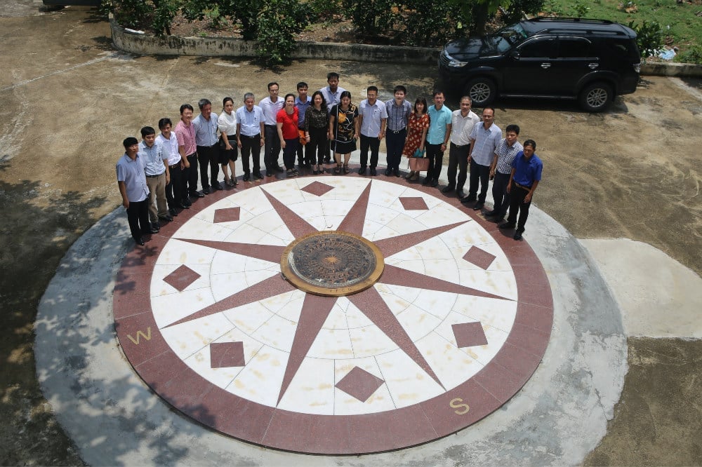
Deputy Minister Nguyen Thi Phuong Hoa and leaders of the Department of Surveying, Mapping and Geographic Information of Vietnam took a photo at the Hon Dau Elevation Marker. Photo: Department of Surveying, Mapping and Geographic Information of Vietnam.
An important milestone is that in 2025, the Government will announce the Baselines in the Gulf of Tonkin, implemented by the Department, with the map deposited at the United Nations, creating a solid legal basis to protect national sovereignty and jurisdiction and serve the development of the marine economy.
In 2024, the Ministry of Natural Resources and Environment issued Circular 33/2024/TT-BTNMT on the List of place names of islands, rocks, shoals... This is an important step to affirm Vietnam's territorial sovereignty, while serving planning, socio-economic development, national defense, and security of sea and islands.
In the field of administrative boundaries, the Department has coordinated with the Ministry of Home Affairs to survey and resolve 16 areas of provincial-level boundary disputes left by history; at the same time, completed a set of maps defining administrative management boundaries at sea and on islands of 28 provinces and cities from Quang Ninh to Kien Giang.
In particular, in early 2025, the Department undertook a huge amount of work to serve the National Administrative Unit Arrangement Project. The collective of cadres and civil servants worked day and night to meet the progress of serving the National Assembly to issue Resolution 202/2025/QH15. Immediately after that, the online Vietnam Administrative Map was put into operation at vnsdi.mae.gov.vn, with nearly 200 million visits, demonstrating the need to exploit open data and the spread of this digital project.
Geospatial infrastructure - the foundation for the digital future
To continue promoting the role of geospatial data infrastructure in national digital transformation, the Department of Surveying, Mapping and Geographic Information of Vietnam recommends:
Perfecting policy mechanisms to attract high-quality human resources in the fields of information technology and geospatial technology, paying salaries according to job positions, linked to productivity and product quality.
Increase investment in hardware and software infrastructure, processing, storage, security and data sharing capacity to ensure accurate and timely information to serve the construction of e-Government, digital economy and digital society.
In the data era, surveying and mapping are not only “the science of the earth and sky” but have become the digital language of development. From precise coordinates, Vietnam is creating a unified, sovereign and sustainable digital space, where each map pixel contributes to the green, modern and safe development of the country.
On the occasion of the 80th anniversary of Agriculture and Environment Day and the 1st Patriotic Emulation Congress, the Ministry of Agriculture and Environment will organize a series of events from July to December 2025. The focus will be on the 80th anniversary of the Agriculture and Environment sector and the 1st Patriotic Emulation Congress, held on the morning of November 12, 2025 at the National Convention Center (Hanoi) with more than 1,200 delegates attending. Agriculture and Environment Newspaper will broadcast this event live.
Source: https://nongnghiepmoitruong.vn/du-lieu-dia-ly-quoc-gia-ha-tang-so-cho-phat-trien-ben-vung-hien-dai-d770262.html




















![[Video] Hue Monuments reopen to welcome visitors](https://vphoto.vietnam.vn/thumb/402x226/vietnam/resource/IMAGE/2025/11/05/1762301089171_dung01-05-43-09still013-jpg.webp)











![Dong Nai OCOP transition: [Part 2] Opening new distribution channel](https://vphoto.vietnam.vn/thumb/402x226/vietnam/resource/IMAGE/2025/11/09/1762655780766_4613-anh-1_20240803100041-nongnghiep-154608.jpeg)



Comment (0)